|
 Sipsey Wilderness Area, AL:
February 18-19, 2017
Quillan Creek, Riddle Creek
Distance: 7 miles
[View Photo Gallery]
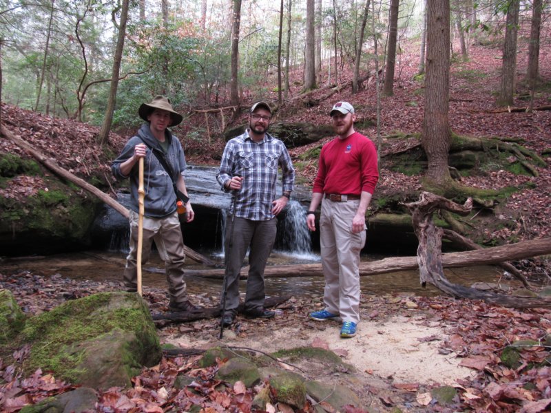
Some seven years since we last set foot in the woods together, Randall, Matt, and myself broke the streak on a much needed return to the Sipsey Wilderness. These get togethers are few and far between now, and it's been even longer since the four core members of the branded Muddy Boot Clan [Mississippi Chapter], missing Justin this trip, were in the same place at the same time. For this adventure, I proposed a complete off trail excursion, something the group has never done. Quillan Creek, one of the most beautiful places in the entire National Forest, and a personal favorite within the wilderness area, felt the perfect setting. There are few places in the wilderness I'm willing to return to year after year, but Quillan, with the loop out up Riddle Creek, is one of them.
 After dropping Matt's car off at the small gravel pull off where we planned to exit, we took mine back to the solitary spot across the street where the Arnold Motorway starts. We stopped to chat for a minute about the old trail sign, something only a few which remain, and how the old motorways once made up the trail system here. There seemed a good many more blowdowns this winter than last, but that made for more opportunities to photograph fungi and thick moss, green from the recent rains. The easy path in the initial stretch made for a good time to catch up with each other. I'm always amazed that as popular as Quillan seems to have become at the lack of a hard worn social trail down into the canyon itself. Descending into the canyon, I stopped to snap photos of asters, just beginning their spring dance, and of spotted wintergreen, though no one would chew a piece. Once the old road becomes impassable, it's very much a bushwhack down that last leg to where the motorway crosses Quillan. At the crossing, I mentioned a mill that I'd never seen upstream of the junction, perhaps a quarter mile or so. Matt and I crossed on an old tree that thankfully wasn't wet, while Randall found a way to rock hop instead. I'd never ventured upstream of this junction, and the old mill was something that had been on my list of places to see for some time. We stopped to look at coyote tracks, and also chat about other wild creatures, especially the hogs, and what to do with the food that night. As we continued on, opting to go up and over rocks and around washouts instead of crossing, it grew increasingly clear to me that this mill was likely more at the head of the canyon, and I had no idea how far that would be. We passed an old fire ring, and stopped to admire the view as the stream wound another bend before heading back to the motorway crossing. Randall took notice of the small falls where another fork of the creek joins right at the motorway crossing, which made a great backdrop for a group photo. This was as far as we went up this stretch as well, and come next fall or winter, I need to remedy that. Perhaps the first hike of the next off trail season will be to fully explore the upper reaches of Quillan Creek, and notch off one of the remaining spots I've yet to see in the Sipsey Wilderness. Heading downstream, there were lots of pig sign, and also human sign in the form of flagging tape. I'd already stuffed a pocket full just from our descent into the canyon itself, and now began filling my camera bag's side pockets instead. As the social trail wound under the large fallen beech, we stopped to photograph lots of pig prints. Once past the next fallen tree, which boasted some really pretty orange tinted fungi, we found an old carving that appeared to be a figure of some kind, some symbols, and a date of 1914. Randall and Matt eyeballed the first little drainage coming in from our left, which, as it had last year, numerous flagging tape hanging leading up it. Knowing the blowdown mess and a half from last year, we skipped it as I touted the wonders yet to see downstream. A taste of some of the cliffs came up at the first stream crossing, and soon, we reached one of the cascades, full of potholes deep enough to swim or even dive into. I've touched bottom with a large tree branch before in one at a depth of eight or nine feet. Getting here to actually swim in the summertime would be the biggest issue. My recent health issues continued to be a problem, with my shaky knees making me second guess my normal route across and opting to chance rock hopping instead. We stopped for a drink around the bend at the first true falls, and the site of one of my favorite views in the entire wilderness area. I've said it a thousand times probably, but this spot is magical. It's pristine. It's wild.
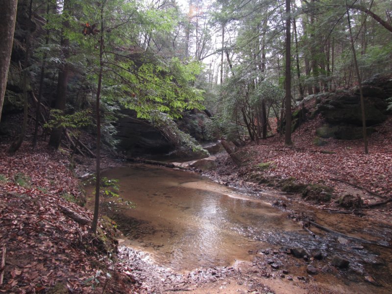
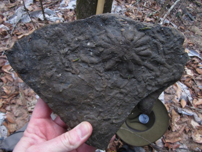
 We stopped for a break here, to photograph club moss and talk about the interesting fossil still sitting upright in the middle of the creek. I ventured out to look for smaller specimens to show the guys up close, but came up empty handed. The route out to the main fossil required getting wet this time, so we settled for some long distance photography and went on southward. The intermittent falls just across from the tall tower like bluff wasn't flowing well for once, so I only stopped to photograph rattlesnake plantain before moving on. The sloped hill forced us down creekside, and we stopped at the spot where Dan Hull and I camped years ago where a nice side stream meets Quillan. Dropping our packs, this was as good a place as any to at least have a late lunch. We ventured up to see the cascades, with it's burnt orange iron seeps and vibrant green mosses. It doesn't seem to matter how much rain we've had or not had, the flow always seems to stay about the same with this falls. I briefly climbed above the initial falls for the view, but decided against venturing to the other falls upstream as we still had some ground to cover before we made camp. Downstream, we ventured through what I've always described to people as an area that has a bit of a rain forest feel. Go when the leaves haven't covered everything, and the lushness of the thick moss is something to see. I spotted a shelter or a possible cave on the other side of the creek, and it's been so long since my last visit here I'm unsure of which this actually is, or if I ever explored it. The cliffs and large boulders here finally conjured up that wildness I think most associate with the Sipsey Wilderness, something more akin in scale to what one finds along Thompson Creek and some of the others. There's a quiet and a solitude here not found there, though.
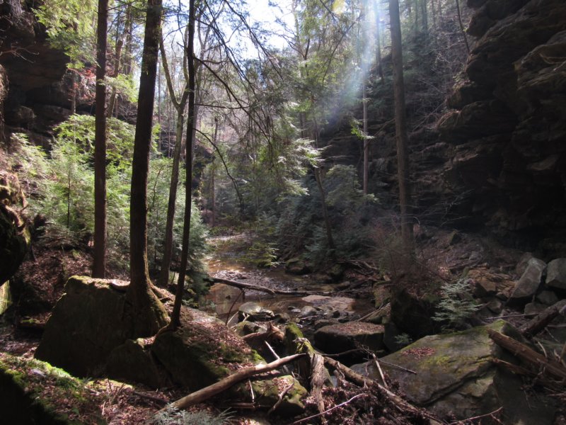
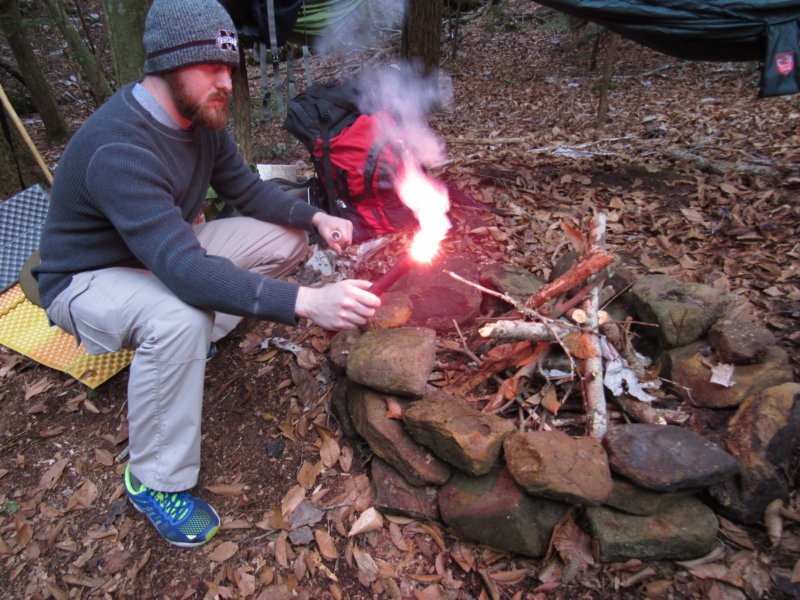
We stopped to look at the long fronds hanging from the tall boulders, some pitted with almost typical honeycomb formations found here. Under a small overhang we found a fire ring in an unusual spot, on a bit of a rock lip with room enough for one on a sandy bed adjacent. It'd been recently used, but thankfully left clean. We followed that path around, up, over and under the slow going maze before the sound of water caught my ear; a tall intermittent falls of about 30-40ft that I'd not seen in flow before echoed from the shelter next to it. As we passed through the tornado damaged area of the forest, that brought up memories of the outbreak of 2011, but of those that ran through my head, I kept to what affected the forest here, and of the damage along Bee Branch and other trails, of how the Big Tree, at least, was spared. As the land began to flatten out just a a little, the search was on for a collection of trees with a certain spacing. Having all brought hammocks, we were intent on finding a location that would allow us to form a bit of a perimeter with the hammocks, and nestle a fire within. After a few more stream crossings, we spotted an old fire pit on a high bank above Quillan, right next to a trickling stream I'd explore later. Not wanting to spend the entire day searching for a site, we decided to make this a preliminary base camp, and explore without packs downstream a hair just to see if something better would turn up. While there was plenty of flat land around, and even another little waterfall I don't think I've seen, there wasn't anything that matched what we'd just found, especially with two large fallen trees to provide way more than enough wood than we'd need for a fire. We brought rocks up from the sandbar for a nice temporary fire ring, but instead of collecting wood I decided to scratch the itch and see what was feeding this little bubbling stream we'd camped beside. I somehow always pick the harder routes in. Stumbling through a lot of dead fall before reaching the 20-30ft bluffs with lots of younger hemlocks obscuring the view of a narrow but nice falls of equal height. The steepness and excessive mud in the shelter behind the falls forced me downhill More impressive were the bluffs on the far side rising at least double that with a small shelter that probably provided an outstanding overlook of the forest below, if one could find a way to it. Back at camp, we made quick work processing the fallen tree. I also brought along a road flare as a backup plan for fire starting, and with the wet wood, this became the ace in the hole we needed. Matt, having inverted his hammock to avoid sleeping atop the bug netting, found the slicker underside too much, and performed an acrobatic flip that tested my reflexes grabbing him before he could slide off the bank and into the creek. It was a classic [and funny] moment that's really hard to describe, but something we'll not soon forget. For our meal that night, I broke out a new skillet I'd bought just for camping, and whipped up my favorite cold weather trail treat, Knorr's Spanish Rice with some precooked chicken. I talked Matt into trying some, as I'd really made enough for the three of us to all have some. The rest of the evening was spent chatting of adventures old, how great this was to get together again, and of future plans. I woke late, or extremely early with something crunching leaves through camp. There was certainly more of a chill in the air than the forecast had suggested [we saw upper 30's instead of upper 40's]. With the moon out, and shining brilliantly, I stayed up and watched it as it passed from one tree to the next in and out of shadow. When dawn finally broke, I gathered some kindling as I knew the others would want a fire, and I'm not against shaking a morning chill. There were thankfully enough embers still around to rouse a flame without resorting to some kind of firestarter. After breakfast, though, I made sure we ferried enough water to completely extinguish it, returned the rocks to the sandy bank, and
recovered it all with leaves, as if we'd never been there. The way it should always be.
We stopped for a break here, to photograph club moss and talk about the interesting fossil still sitting upright in the middle of the creek. I ventured out to look for smaller specimens to show the guys up close, but came up empty handed. The route out to the main fossil required getting wet this time, so we settled for some long distance photography and went on southward. The intermittent falls just across from the tall tower like bluff wasn't flowing well for once, so I only stopped to photograph rattlesnake plantain before moving on. The sloped hill forced us down creekside, and we stopped at the spot where Dan Hull and I camped years ago where a nice side stream meets Quillan. Dropping our packs, this was as good a place as any to at least have a late lunch. We ventured up to see the cascades, with it's burnt orange iron seeps and vibrant green mosses. It doesn't seem to matter how much rain we've had or not had, the flow always seems to stay about the same with this falls. I briefly climbed above the initial falls for the view, but decided against venturing to the other falls upstream as we still had some ground to cover before we made camp. Downstream, we ventured through what I've always described to people as an area that has a bit of a rain forest feel. Go when the leaves haven't covered everything, and the lushness of the thick moss is something to see. I spotted a shelter or a possible cave on the other side of the creek, and it's been so long since my last visit here I'm unsure of which this actually is, or if I ever explored it. The cliffs and large boulders here finally conjured up that wildness I think most associate with the Sipsey Wilderness, something more akin in scale to what one finds along Thompson Creek and some of the others. There's a quiet and a solitude here not found there, though.
We stopped to look at the long fronds hanging from the tall boulders, some pitted with almost typical honeycomb formations found here. Under a small overhang we found a fire ring in an unusual spot, on a bit of a rock lip with room enough for one on a sandy bed adjacent. It'd been recently used, but thankfully left clean. We followed that path around, up, over and under the slow going maze before the sound of water caught my ear; a tall intermittent falls of about 30-40ft that I'd not seen in flow before echoed from the shelter next to it. As we passed through the tornado damaged area of the forest, that brought up memories of the outbreak of 2011, but of those that ran through my head, I kept to what affected the forest here, and of the damage along Bee Branch and other trails, of how the Big Tree, at least, was spared. As the land began to flatten out just a a little, the search was on for a collection of trees with a certain spacing. Having all brought hammocks, we were intent on finding a location that would allow us to form a bit of a perimeter with the hammocks, and nestle a fire within. After a few more stream crossings, we spotted an old fire pit on a high bank above Quillan, right next to a trickling stream I'd explore later. Not wanting to spend the entire day searching for a site, we decided to make this a preliminary base camp, and explore without packs downstream a hair just to see if something better would turn up. While there was plenty of flat land around, and even another little waterfall I don't think I've seen, there wasn't anything that matched what we'd just found, especially with two large fallen trees to provide way more than enough wood than we'd need for a fire. We brought rocks up from the sandbar for a nice temporary fire ring, but instead of collecting wood I decided to scratch the itch and see what was feeding this little bubbling stream we'd camped beside. I somehow always pick the harder routes in. Stumbling through a lot of dead fall before reaching the 20-30ft bluffs with lots of younger hemlocks obscuring the view of a narrow but nice falls of equal height. The steepness and excessive mud in the shelter behind the falls forced me downhill More impressive were the bluffs on the far side rising at least double that with a small shelter that probably provided an outstanding overlook of the forest below, if one could find a way to it. Back at camp, we made quick work processing the fallen tree. I also brought along a road flare as a backup plan for fire starting, and with the wet wood, this became the ace in the hole we needed. Matt, having inverted his hammock to avoid sleeping atop the bug netting, found the slicker underside too much, and performed an acrobatic flip that tested my reflexes grabbing him before he could slide off the bank and into the creek. It was a classic [and funny] moment that's really hard to describe, but something we'll not soon forget. For our meal that night, I broke out a new skillet I'd bought just for camping, and whipped up my favorite cold weather trail treat, Knorr's Spanish Rice with some precooked chicken. I talked Matt into trying some, as I'd really made enough for the three of us to all have some. The rest of the evening was spent chatting of adventures old, how great this was to get together again, and of future plans. I woke late, or extremely early with something crunching leaves through camp. There was certainly more of a chill in the air than the forecast had suggested [we saw upper 30's instead of upper 40's]. With the moon out, and shining brilliantly, I stayed up and watched it as it passed from one tree to the next in and out of shadow. When dawn finally broke, I gathered some kindling as I knew the others would want a fire, and I'm not against shaking a morning chill. There were thankfully enough embers still around to rouse a flame without resorting to some kind of firestarter. After breakfast, though, I made sure we ferried enough water to completely extinguish it, returned the rocks to the sandy bank, and
recovered it all with leaves, as if we'd never been there. The way it should always be.
 Headed downstream, we passed the little intermittent stream I'd yet to see and kept going, only stopping once we reached the section of stream where Dan and I found fossils years ago, and found another here! At the next bend I opted to ford the creek to explore more rocks on a wide rocky bar, finding a few more to my surprise. I crossed back and caught up with guys, discussing the fossils and more tornado damage. Beneath one of the uprooted trees a seep or small spring seems to have surfaced as a result, and the pigs unfortunately have discovered this as well. Exploring another rocky bar along the bank, we stopped to take the in sun, now high enough to illuminate the boulders on the far bank, and enjoy the silence. I took note of an interesting rock uphill I couldn't help but check out, especially with the large beech in front of it. With some ongoing health issues, the short jaunt to reach it had me out of breath, but the payoff was a neat little overhang, enough shelter for one or two and space for a fire if needed. The beech had no noticeable markings on it, but I did notice some nice clumps of reindeer lichen around. I've had a renewed interest in mosses and lichen, of late, something new to add to a list of flora I'd like to be able to identify with ease in the woods. We also stopped to look at cranefly orchid, though I see so much of this it's almost not worth pointing out anymore. As the land leveled out ahead, more great views of the creek and the scrubby area appeared that's kind of indicative of junction with Riddle Creek. The old fallen beech was still holding strong across Quillan, but it was too early in the year to see if it'll sprout leaves again this spring. Crossing Riddle Creek, we dropped our packs near where we'd intended to climb above the canyon, to help make faster work of reaching the lower falls. Once through the young hemlock grove, the forest opened a bit more, and we descended through a bit of a boulder garden to a good one hop crossing. Along the way we found the first sign I'd seen of toothwort, and resurrection fern, one of my favorite ferns out there. We also saw some fresh hog sign, but thankfully no hogs. We ventured uphill to the great overlook spot to the left of the falls, and walked out along the long narrow lip that provides access to the secondary falls above it, if a bit treacherous; it was too risky with my knees to consider this day. Being the last real scenic highlight of the trip, we took time to enjoy it and chat about the beauty of this place. Back with our packs, the sharp incline proved the hardest part of the trip, and I needed multiple breaks before reaching the short bluff above. Hoisting Randall up, we got our packs up before using a rock he'd secured to get ourselves above the 7ft wall. The exertion took it's toll on me, and I had to rest for a bit, one of the few times I've been extremely lightheaded and almost 'seeing stars' on a hiking trip. Determined to find a better place to take a more extended rest, we made a beeline for the ridge, digging our way through thick mountain laurel before finding a conveniently placed fallen tree for snacks and to let me really catch my breath.
 The ridge here was reasonably easy to navigate, with just a few blowdowns to get through. One of which sported the first butterfly I'd seen of the year, a gulf frittilary. Having learned my lesson about continuing this path from a camping trip years ago with Dan that had us walking in circles, we quickly descended into the intermittent drain that feeds the seasonal second falls next to Hurricane Creek Falls. A short hop over that and we were climbing again. Over the ridge I picked up a game trail that led to a steep slick descent again past a small rock overhang just above the middle falls. Due to time and general tiredness, we chose to skip backtracking to the falls and head upstream instead, rock hopping and jumping across the stream as it meandered. A large rock outcropping with a seasonal falls in very low flow appeared, and then a second, larger one approximately 15-20ft high did, with an appropriate tree across it to obscure any good camera shot. We climbed the small cascades and crossed on the same tree I crossed on years ago, a 15ft bluff bordering the stream just above the falls. From years of weathering the rock had been carved into a bit of a shelter, completely overhanging the stream. The 10ft upper falls came into view, and we took time to eat a snack. To the left of the falls the secondary feeder stream was flowing well, falling off a 5ft or so cascade on it's way to the creek. Above the falls, fresh dug areas from wild hogs was everywhere. As the water channel began to narrow, the feeling of being in the upper part of the basin returned, and with it, the beech groves. I made sure we stopped and studied the “johnny hands up” tree, which had cracked the last time I'd seen it, though there was no evidence of an eminent demise. The carvings have weathered a lot since the first time I saw them in 2009. As the trail past it split, old dug out areas from former moonshine stills could still be found, and I pointed out the rusted remnants of one on the far side of the creek. As the canyon reached it's end, we ended up in tall thicket, though the leafs not being out really saved the day. While I'm against their use in the wilderness or woods in general, the flagging we found here helped guide us up the right channel, as I wasn't terribly certain anymore which would lead us out right at our vehicle. The trail did end up dissipating, and we followed what eventually became an old road bed, with the view of our vehicle in the distance. With the long hike behind us, we made plans for future excursions, said our goodbyes and made our way back home.
|