|
 Green Mountain Preserve, AL:
April 1, 2017
Alum Cave Trail, East Plateau Loop, West Plateau Loop, *unnamed unfinished trail*, Oak Hill Trail, Buzzard Falls Trail
Distance: 4.5 miles
[View Photo Gallery]
I first hiked this new preserve before it was even named last year, and quickly fell in love with it. It has a certain feel to the place that the other preserves around don’t. It also hasn’t been loved to death by hikers yet. So when I’d heard there were new trails with signage I decided to take the afternoon and go explore them, joined late in the outing by Brandi and Zack. In addition to the new trails at the preserve, I stumbled across another set of trails I’ve only briefly heard about, part of the Oak Bluff subdivision. These trails greatly expand upon the existing land trust trail system, ultimately culminating at a place I’ve wanted to see since I first heard the name: Buzzard Falls.
 I stopped at the trail kiosk to see if the map had been updated, but it hadn't. However, a new informational sign talking about the history and Native American use of Alum Cave had been put in. I set out down the Alum Hollow Trail, which, despite late March, was still completely barren of wildflowers. Crossing the narrow stream and the tree with the elongated trunk on the ground people are using for a bench, I stopped to take in some of the early spring views down Alum Hollow. Soon I found the turn off for one of the new trails, the East Plateau Trail. The flat trail soon made a hard left as a whole slew of no trespassing signs and a newly installed fence blocked where it looks like an old road led. As I wound through a more mature section of forest, the tops of some of the mansions being built in an area between the Madison County Nature Trail and the newer preserve here were visible. Those views disappeared as the trail seemed to wind further into the woods and more into the upper part of a drainage, the afternoon sun illuminating the first green leaf sprout I'd seen close to a dry stream crossing. Rounding the bend brought more views of people's homes, but at least this preserve doesn't suffer from the noise pollution like some other spots in town do. I don't expect true wilderness in these urban green spaces, so my notes about seeing houses here are more observational than a complaint. Soon another stream appeared, this time flowing quite well and most certainly the upper reaches of probably the first set of small cascades before the the bridge crossing. This seemed like an environment ripe for good wildflowers with the water availability, something I hope to check on later this spring. All along this trail, I took note as well of the number of natural benches created from fallen trees once blocking the path. It's great to see this method used, keeping the land in a more natural state. Bearing another hard left, the power line cut along the back of the preserve property came into view, with a new culvert in from drainage from the subdivision, a winter grass bright green standing in stark contrast. The trail crossed the minor stream from the culvert here, the water collecting in a shallow pool on the north side before disappearing under the trail briefly. Anchored by a few large trees, the trail here is perhaps safe from erosion issues. Past this point the path finally gains some elevation, and is probably one of the steepest sections of the trails that have been built thus far. Toward the top of the ridge here, I spotted an old campsite that's really only recognizable because of how the fallen branches were arranged. Also here were just a few leaves of toothwort, which is amazing as across town I'd found the plant already in bloom weeks ago.
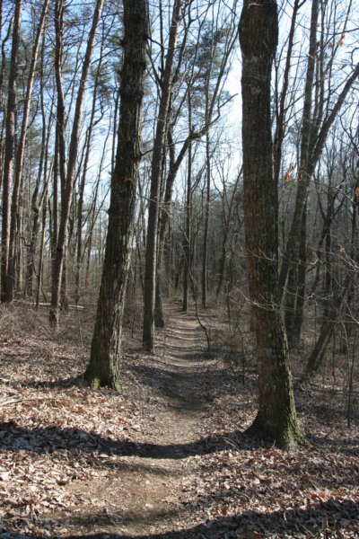 Tying back in with the Alum Cave Trail, it was a short jaunt up to where the trail descends to the bridge crossing above the cascades. Instead of that route, I followed another little trail that ventured off to the right, paralleling the stream all the way back to the power line cut. An old access road continues here across the cut and into the subdivision, and I wonder if this is part of a future route that the developer agreed upon to allow a connector between the preserve and the Madison County Nature Trail. Returning to the junction, I hiked down to test out the nice new bridge over the creek, though the old bridge of three logs tied together still sits next to it. So long as the trail wasn't crowded, this makes for a great spot to hang out and enjoy the gurgling stream and the quiet. Past the bridge, the other new trail, the West Plateau Trail, splits off to the right not far uphill. Kind of rounding the backside of the knoll at this point, it flattens out pretty quickly, and also features a flagged spur trail that appears to lead to the subdivision as well. I assume it dead ends for now at the power line cut, so I skipped exploring it in essence of time. Quickly climbing to to top of the ridge, the woods through here are the thickest of anywhere along the trail, save the riparian areas. Half the length of the East Plateau Trail, it soon begins it's descent into the drainage for the main stream where the falls are in Alum Hollow. This upland strip of forest above the falls is probably my favorite area outside of the falls itself. The openness of the land, and the little stream running through it just speaks to me. Further down trail, I spot an indian marker tree, possibly marking an old path as it seemed to point either away or parallel to the shelter. I do know that somewhere on the ridge archaeological evidence has been found of a previous Native American settlement here, so perhaps that's that it pointed toward.
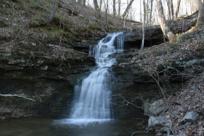
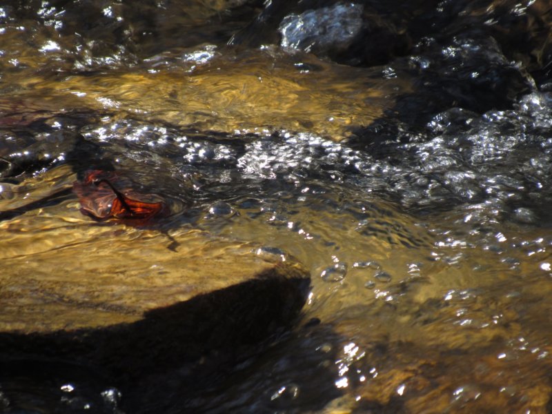
Soon the rush of water from the falls filled the air and the Eastern Plateau Trail rejoined the Alum Cave Trail at one of the switchbacks above the falls itself. Here, finally, the wildflowers returned a bit, with spring beauty, mountain saxifrage, and a few trillium [not yet in bloom] all along the steep hillside leading down to the falls. I had intended to wait here for Brandi and Zack, but after some encouragement some other older hikers I decided to explore on past the second falls a ways to see what I could find, and turn back at a reasonable point. With good recent rains, both of the falls were flowing better than I'd ever seen them, with the second falls even sporting twin falls, thanks to a tree above the rim. I took the slippery path up to the top and followed the trail along the bluff a ways until it ventured uphill, reaching a junction. A sign there read “Oak Bluff Trail” with an arrow, so I followed left, the trail pulling in away from the cliff edge a good bit. Winding out to a point, limited views of the far south side of Huntsville and the river were visible here. Turning back into the forest again and uphill, I came across rectangular sections of dirt excavated alongside the trail. These were a bit baffling, as they obviously weren't old burial plots, and didn't ring true for archaeological excavations either. The trail came back along the edge for a while, passing an easy way down into the canyon, as well as a slightly flowing narrow stream. Paralleling the watercourse, I turned left at the next junction, following a trail sign's lead. As the path leveled off, blowdowns popped up here and there, as this area isn't officially maintained by the land trust. In the distance, the distinct silhouettes of homes were visible, and I knew I wasn't far from the subdivision where the trailhead Buzzard Falls supposedly was. Crossing another stream fed by a drain pipe that appeared to have a capped spring of some kind, I quickly took notice of a sign for the Buzzard Falls Trail. Since I was already almost to the trailhead, I made quick work of the last quarter mile or so up to the cul de sac, which mentioned the trail but featured no true trailhead of any kind. It did, however, feature a sign that read “Private Property\ Oak Bluff\ Hikers Welcome”, a bit of an oxymoron. Before departing, I walked around and photographed a large pond there in the middle of lots of mature trees.
 Backtracking to the Buzzard Falls Trail, I'd received a text that Zack and Brandi were on their way, but with the poor cell service I was really unsure of when the message was sent. Being this close to Buzzard Falls, though, I was quite sure, though, that I'd at least go see the falls before heading back. The trail followed along the ridge beside the stream, eventually taking a rock strewn path down, the pink flags helping mark some of the sketchy places. Crossing the very shallow stream, I passed two cascades that would be absolutely stunning if running at full flow. Different from earlier, the canyon walls some of rose some 30ft above the canyon floor itself. The steep walls gave way to easy grade and equally steeped hillside, with scattered pockets of rock outcropping. Passing a long narrow stone easily used for a bench, I quickly realized I'd bitten off more than I could chew with the daylight. The path zigzagged in and out of small rock gardens, which included crossing or finding a way around a number of blow downs. At times, the way was almost indistinguishable with the fallen leaves, but the white blazes were very prominent, even in the failing light. I'd hoped to possibly spot the well known cave somewhere down in valley below the shelf I'd been hiking on, but it was impossible to spot and there was no time to explore it. As larger boulders began to appear, so returned the views down into south Huntsville. The trail made a hard right uphill, and after a mile or so from the earlier junction I finally was back to a cliff, if a small one. It quickly increased in height, and the 20ft Buzzard Falls, flowing well for this time of the year, came into view. I would have loved to followed the falls back up to it's spring fed source, but instead followed the trail a little longer, passing toothwort and foam flower enjoying the wetter conditions, neither yet in bloom. The trail passed under a large boulder, not unlike the “squeeze” on the Borden Creek Trail in the Sipsey Wilderness. Forming a kind of secondary cliff, I found an slot opening that allowed access behind the falls, which deer seem to be using as shelter. Somewhere through here I had just enough service to get a message from Brandi saying they were at the falls, and pretty much where the heck was I. I had no good answer explaining how to get to where I was, or even how far out I really way, so I just guesstimated a time I could meet them, and hurried back. I made some seriously quick work back to where the Oak Hill Trail turned uphill bisecting an old road, and surmised that this old road must form a loop and end up at the other end of junction just above the second falls. The old road made for easier walking, if a bit creepy. There were numerous long rectangular holes dug along the road itself and all out in the woods here, several reasonably fresh digs as well. As the road went on, pink flags began appearing, and at another old road bed, double flagging where I turned right, leading me as I suspected to the junction above the second falls. On a normal day this kind of hike wouldn't bother me, but in the height of one of the worst colitis flares I've ever had, I couldn't catch my breath. I did finally catch up with Brandi and Zack, who had retreated to the bridge by the cascades. As we passed the large marker tree near a great spot to watch the sunset, we noticed new trails with flagging leading down into the canyon here. Brandi decided to continue on on established path, while Zack and I marched down switchbacks to see where it led. We both suspected it came up alongside the first intermittent drain you pass on the Alum Cave Trail, as there's a bit of a game trail at least there. Alternating between fresh groomed trail and looking for the next blue flag, this new trail looks to lead down through a seriously interesting part of Alum Hollow. Revealing a low bluff not visible from the trail above, small caves or shelters were visible in several spots, and the rock features along either side of the new path will be by far the most interesting thing in this preserve, assuming it doesn't eventually expand to include the Buzzard Falls area. Atop one of the large boulders here was a rock cairn, but maybe another time with better light will reveal whatever significance this might have had. Descending shelf after shelf, we finally concluded the trail was not going to loop back up. The climb uphill off trail is one of the absolute steepest inclines I've ever climbed, slipped, and fallen my way up, and rarely have I been as out of breath [thanks again colitis]. The saving grace was that at least we weren't but a quarter mile or so from the trailhead, and the flat walk made for a good cool down walk. A good hike deserves a good finish, so we ended the adventure with a trip to Below The Radar Brewhouse for the best burgers in town before heading home.
|