|
 Sipsey Wilderness Area, AL:
February 5, 2017
Upper Hagood Creek
Distance: 5 miles
[View Photo Gallery]
As one of the last remaining stretches of the Sipsey Wilderness I hadn't set foot on, the upper part of Hagood Creek seemed as good a choice as any, and short at that, to test my endurance and stamina levels after a rough couple of months with a bout of colitis. Meant as kind of a companion hike to my 2013 hike on Hagood Creek, I was intent on finding the elusive “foot falls” that I'd literally stood at the base of, and also venture upstream to find whatever other little secrets this part of the forest might hold. With an arduous beginning that nearly shut down the hike not long after it started, and a confrontational situation that ended it early, my 2017 off trail excursions started off with more than a bit of adventure.
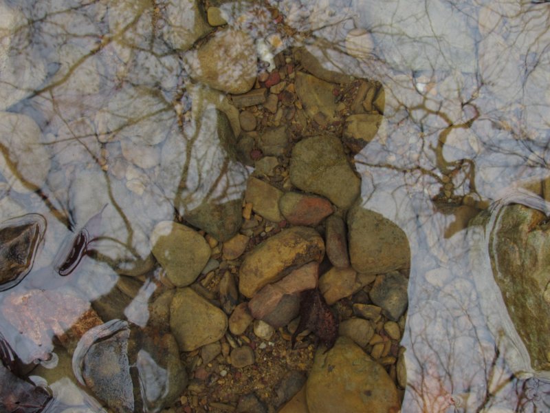
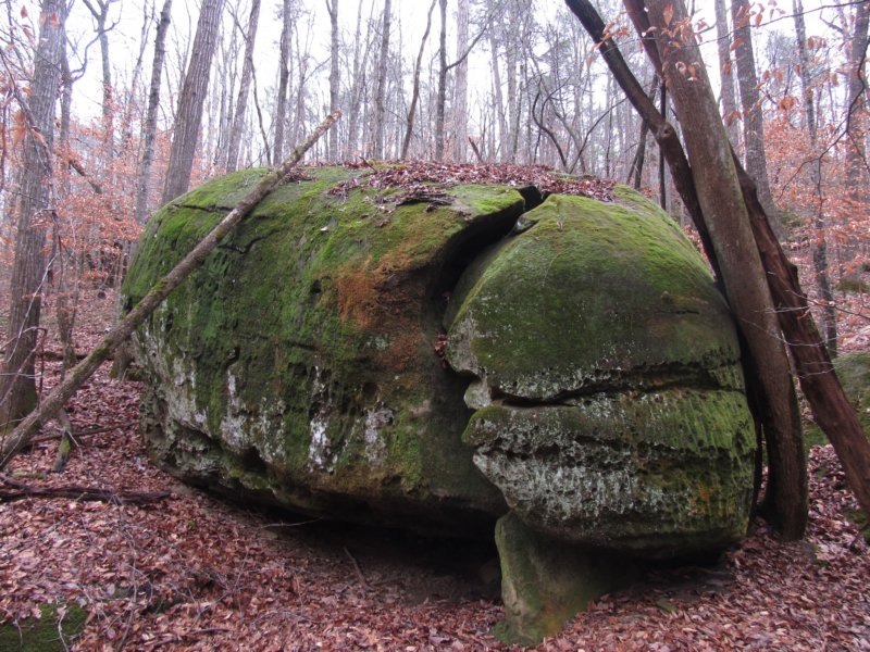
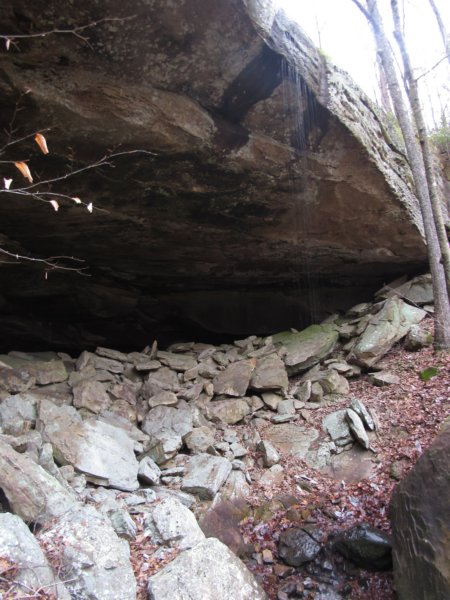 I parked near Pinnacle Ridge, and set out downhill after analyzing to make sure I wasn't dropping into the wrong drainage, but by the time I got to the first little drop off I knew something was up. The short rock bluff with it's little colony of filmy ferns, as I remembered from last time, was one drain down from where I wanted to be. Instead of backtracking uphill, I opted to just explore this drain again, also forgetting this was the really long drain, and would eventually take about an hour of time away that I wish I'd had back toward the end. The water picked up in the little stream quickly, recent rains helping the drought which still hasn't abated. I'd hoped to see maybe a few early spring wildflowers given the warm winter, but so far only crossed paths with the typical sedges, spotted wintergreen and cranefly orchid leaves that dominate the late winter months. Below the second falls, and the first one running, a brief glimpse of toothwort did say hello as I stumbled and fell on slick leaves and rock, mentally cursing myself for leaving the hiking staff in the car, a rare occurrence. I stopped to rest and explore one of the smaller bluffs here, and attempted to get up and above it to hop the ridge into the other drainage, but never quite found a spot I could force myself up. Having already seen this creek, I opted to stay on higher, flatter ground, passing hog wallows and numerous sinks I'd not seen before. Hearing the tinkering of water, I found a small opening enough for one person straight down into a pit style cave, though the water falling into it was more seep than waterfall. I could tell from the photographs I snapped that at the bottom of the 15ft drop there appeared to be an opening of some sorts off to the side; caves are still off limits on national forest land here, though The land then stair stepped through long moss covered rows of rocks, with me zigzagging through the gaps down to Hagood Creek to avoid slipping. As the high banks subsided heading upstream, I came back to the stretch of creek that I enjoyed exploring so much several years ago. Much like the upper reaches of Thompson Creek, well away from the crowded trail of the same name, there's places of complete serenity, and for me, this stretch along Hagood is one. The tall beech still dangled at an angle stretched wide across the creek, and the moss on the small rock outcropping that resembled a home for gnomes looked just as I recalled. I picked up the old road bed from before, unfortunately finding fresh litter, likely from hunters, and more aluminum cans stuffed on top of chopped saplings to mark a route than I had space in my camera bag to haul out. Reaching the next stream, the one I'd originally intended on descending in, I stopped for a few minutes to admire a narrow little channel of water here that's cut a narrow course through the rock bottom, filled with various algae of differing colors. I also stopped to see Tom's Cave once again, the single supplier of water at this point to the little stream. To the left of the cave, and center of the main dry double channel, the busted moonshine still seemed more busted than before, with one section missing the cap that I'd seen on it before. Retreating to higher ground on an old road bed, I made quick work up the side canyon, passing the spot with the easy exit [though I'd forgotten about this at the time], and making my way to the head of the canyon. I stopped to photograph a unique concretion, which resembled a dark purple open faced hornet's nest, perfectly smooth in spots on the inside.
Inherits inline styles then resizes proportionally when media query enabled
To my surprise, Foot Falls as it's locally known, was flowing. I searched for a bit before finding an extremely narrow slip of land that appeared to be a game trail providing access to the top of the bluff, and quite tenderly made my way along and up it. A fall from here meant a good 15ft foot drop, if you were lucky enough to grab a tree so you didn't continue bouncing downhill. Bracing against a well placed tree, I managed to grab handfuls of mountain laurel and drag myself up and underneath them, crawling on all fours for a while before breaking out of them uphill. Getting to the falls forced me to plow back through them, though, with some pretty nasty briers wrapped in along the way. The lack of endurance and health issues caught up with me at this point, forcing me to stop once I got to the edge of the falls and rest for longer than I would have liked. The break allowed for the discovery of two disjunct section of the carved footprints above the falls, one to the left on a sharp angled part of the water course. The others were covered with leaves and dirt at times, though I managed to photographs many of the initials, the name “Riggs”, and two dates from the 1800's, one being 1893. The most recent of the dates I found was 2004. I gave a lot of thought of giving up the hike here, and returning to the car, having seen what I really came to see. The likelihood returning anytime soon was slim, so I pushed ahead. Up the hill from the falls I found another game trail, though this one seemed used so much I suspect hunters use it as well. I followed close to the edge to take in the great views of the valley, crossing a small stream feeding one of the falls I skipped seeing this go around, and made my way up the hill to a pretty open old road bed. Remarkably little vegetation grew here, and the road made for a quick walk back down close to Hagood Creek. Getting down to the creek was a bit of an issue, requiring a bit of a power slide through leaves and a narrow chute between two parts of the bluff. There was no way I was getting out of the canyon this way. Passing another spring and likely small cave, I was back to the crystal clear waters of Hagood Creek. This area is rich in karst formations, and more potential caves and springs appeared upstream, the rocky outcroppings looking as if someone had stacked them in spots instead of something natural. Along the sandy creek banks some small iris were just beginning to sprout, more than a bit early as I'm afraid the wildflowers will be this year. Passing a side creek I'd decided to save until last in an effort to reach the head of the canyon and more interesting spots, I came up a small area dotted with older beech trees. I had coordinates for a “snake tree”, but never found any carvings. I did find a tree with a carving that I could only partially read “---BEAND”, and a date on the backside of 1912. The cloudy skies finally gave out a little rain, but not enough by far to deter the adventure. Usually blooming by now, I spotted some hepatica also just emerging from leaf litter, and even more oddly, it'd be the only hepatica I'd find this trip. The creek began to turn a bit shallow, making the large boulders along the banks seem even larger. I finally was forced to cross to get around a tall outcropping, which allowed a look at another possible cave, which I didn't bother approaching close as it looked like a well used animal den. A brief exploration up the next dry drainage revealed another pit style cave, while Hagood Creek deepened again in spots, producing several 'blue holes'. I passed more springs and outcroppings as the land seemed to widen and flatten out a bit, before returning to bursts of outcroppings, one of which sported a bit of a window or a natural bridge of sorts formed from an adjacent wash eroding it out. Ahead, one of the most interesting features of the day, a large oval shaped pool easily 10-15ft deep in the center was quite the oddity, bordered on both ends by the main creek which wasn't much more than ankle deep. Ahead another grove of beech trees came into view, with a “T” carving and a date of “May 30, 1961” on the first tree. Across the creek another was nearly illegible, reading “W-- 1920”. A date of 1892 was on the reverse side, one of the oldest carvings I've ever found in Sipsey.
I tailed off at the next stream junction on the left side, spotting two marker trees parallel to one another, and then just decided to continue upstream through an interesting boulder garden. The boulders gave way to two narrow streams joining, with a narrow cascade visible to the right, and a four foot waterfall that had some flow to it off to the left upstream a little. I stopped here to catch a breath and reconsider my time. The goal was to reach a waypoint labeled “buggy bluff”, if possible, but the afternoon seemed to now be getting away from me a bit. On the way back to Hagood, I passed a very large carving of “1912” and the initial “B” beneath it, and another with a very large “C”, or possibly meant to be a crescent moon, as I've seen elsewhere in the forest. Back on Hagood, which had completely dried up except for one large spring feeding it, I made quick work of the dry bed upstream for a piece, passing several other dry streams feeding into it. True to the nature of the area, the water started up again, and I came across only the second spot in the wilderness area that I know of where the stream flows back on itself and disappears into a sinkhole. Past here the stream quickly dried up again, and several more dry fingers splintered off from the main channel. At a larger junction, I stopped to look at a spot where it appeared the front of a cave had filled in with large pile of dirt and debris, before heading up the channel to my left. Distracted by some interesting rock formations, I headed up hill to check them out, only to get an eerie feeling something I was being watched. I found what looked like a pig wallow next to a opening in the rocks that would make a nice den, and wrote it off as that. I stepped downhill into the other drainage, which didn't seem all that promising in terms of a falls, instead, finding another marker tree and one of the interlocking “S/J” carved trees with the north arrow on the other side. This one, though, also had a large “B” carved in the same script on a third point on the tree.
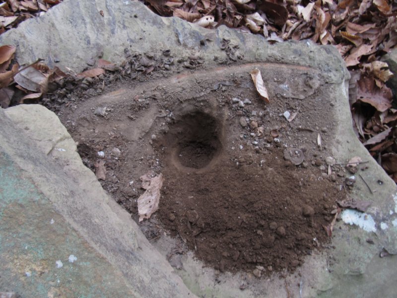 Upstream again, the water returned, and I ventured up the left drain, less than half a mile from the “buggy bluff” point I'd planned to stop at, only to be stopped here by a rush of barking, and half a dozen hunting dogs barreling down the hill at me. I'll be honest, for the first time out on a trail, I looked for a tree to climb, an escape route, made sure my blade was secure, and then began screaming at them to stop. The combined noise of the dogs and my screaming likely scared off anything the hunters, likely on the bluff above [and who never made their presence known] were after. Thankfully the dogs did obey commands and retreated back uphill and out of sight. It didn't take me long to decide that this was as far as I was venturing upstream, but not before I checked out the odd rock shelter at the point of the ridge. Reaching it uphill, I found a small enough space for one or two people to camp, with a a disheveled fire ring. After noticing and moving an odd placed stone I found a mortar stone beneath it packed with dirt. This is the first time I've found a mortar stone purposely hidden, though I've heard reports of people purposely hiding them now. I'm really unsure of the point of this. Still hearing the dogs in the distance, I had a renewed sense of being watched, and quickly made my way back down the creek, only stopping to look at fresh deer scat and photograph some of the interesting colored fungi abundant along the way. Back at the deep blue hole, I followed the second stream feeding it up past a few interesting rock formations before abandoning the search for anything more. Staying higher on the route brought the discovery of cranefly orchid, bloodroot, some far flung roofing metal, as well as a large stand of bamboo. At the “Foot Falls” drainage, I took the easy route out, an old road that led up and down into a bowl of a large sinkhole. A little bit of scrambling up the slick embankment at the head of the little canyon and I was back on the old road atop the bluff. I followed the ridgeline and the old road bed for a long while before it became evident it wasn't getting any closer to Gum Pond Road. The typical off trail veer through bramble and brier ensued, though in hindsight I should have retraced my steps to the falls and simply followed the drainage out that way. Soon enough, though, the road came into view, and I made my way back to the car, still thinking of the dog encounter, happy to check off one of the remaining places I'd yet to see in the Sipsey Wilderness.
|