|
 Point Mallard Park, AL:
Jan 21, 2016
Chief Doublehead Trail, Chief Black Fox Trail, Dr. Bill Sims Hike-bike Way
Distance: 2.75 miles
[View Photo Gallery]
Last year Point Mallard Park unveiled plans to put in four new trails honoring local Native American leaders, of which two were said to be completed. Looking for an easy hike after a tough couple of weeks, months really, I decided to start the year off hiking with Lulu as I usually do, and tackle those trails already established. The adventure of finding these trails though overshadowed the actual trail experience itself, and the beautiful views of the river afforded from the hike helped lessen the surprise of how in need of maintenance these trails already are.
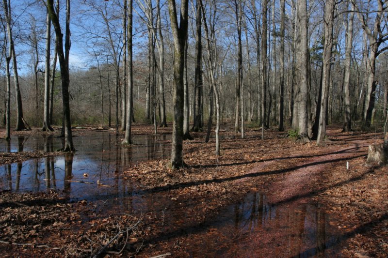
 Despite having lived here for going on ten years, I'd never been to Point Mallard before. My interest in swimming and water parks had never been terribly high, and the area didn't really seem to have much to offer besides that. Nearby Wheeler National Wildlife Refuge had always been, and remains, the more appealing choice. After spotting a number of trails at Point Mallard and following them alongside the road which resulted in a gated road, an elementary school parking lot, and an archery course, I gave up and stopped at a recreation center on site and asked the attendant for a map or any information on these new trails. A nice guy, he even called the campground to see if they had anything after turning up nothing at his office. Their response: �there is no literature on these trails�. No maps, digital or print to guide you. Neither could anyone tell me where the actual trailhead was. I ventured across the road after spotting a sign to instead find the Dr. Bill Sims Hike-Bike Way, a part gravel, part paved greenway that runs alongside the river through the eastern half of the city of Decatur. I was sure the trails must spur off somewhere, but I didn't have the energy to hike 12 miles, or even 6 miles. I traveled down the road past the ballfields, passing a small parking area of sorts at a gated section at a bridge before finding that road gated as well. Right there in front of me, to either side of the golf course, were the two trailheads I'd been searching for. Backtracking to the small parking area, Lulu and I wandered a short portion of the Dr. Sims Trail, partially flooded from the morning rains. Past the gate, the Chief Doublehead Walking Trail began just past an unnamed stream, wide and swampy above the bridge.
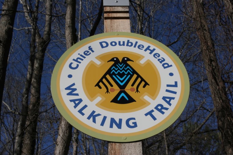
 After stopping to read the history of Chief Doublehead on the informational marker, we set out down the trail, taking the right fork as the sign purported this as a loop trail. I knew from studying an aerial lay of the land that there wasn't a lot of land to work with here, and while hiking, both the sides of the loop were very visible. Some of this is certainly due to the great work done to eliminate invasive privet which had ruled a lot of this land, and hopefully one day they'll introduce native plants along the way to reestablish an understory of sorts. In lieu of markers nailed to trees, small white posts were installed along the crushed red gravel of the path, though the gravel alone was enough evidence to know where the trail led. The morning rains brought out drainage issues right off the bat, with Lulu plunging through them while my progress was more by leaps and bounds in spots. The number of squirrels around seemed to delight Lulu, at least, as she chased them to trees as much as I allowed. The center portion of the forest between the two trail routes here turned into a bit of a lake, overflowing and washing out more parts of the trail. A fallen tree forced a walk around, and from the looks of it, instead of clearing the tree from the path, more gravel was poured around the other side of the tree. One of the big takeaways from the news article on the area, and a very appealing draw for me, was the mentioning that no trees were felled in the creation of these trails, using open sections and natural routes as a guide. From the fallen tree, the view of the golf course was pretty evident, but that view was soon obscured as the trail entered a portion of the woods much younger, and still full of privet. Off to the side, a pile of what looked to be rock caught my attention, though there was an unmarked stone situated at the head of it with other larger stones scattered around. I'm unsure and doubtful this was a grave site, and I didn't study the mound enough to speculate.
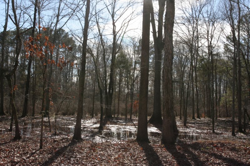 Straight ahead the trail seemed to dead-end at a small lake, and I ventured right briefly to look at the golf course. This setup sort of reminds me of the back-country area of Hays Nature Preserve with it's proximity to a golf course, though Hays is a much more larger space. A number of turtles were quietly sunning on various logs, and I managed to snap a good group of photos before they scurried into the water. The white markers picked up and veered left, kind of around the far end of the lake before meeting a junction with an old road bed. Following right, it led into the deepest section of woods yet, with more flooded area that stayed mostly off the trails. Lulu stopped for a fresh drink here and to play in the water some, and I tried to spy the campground situated on the other side of the woodland buffer here, but to no avail. As the loop rounded, I found three sticks, which either were supposed to be pointing toward something, or perhaps a crude anarchist's symbol, but I never quite determined which was correct. Just ahead was the first real trail blockage, though easy enough to step over. Several large southern magnolia trees caught my eye, the effects of drought here were really most evident on these evergreens now, with one completely dead. Not expecting wildflowers, I stopped to look at a few sprigs of partridgeberry and some small asters nestled against the large roots of a tree. From the pile of broken nut shells, squirrels were also using this spot to feast it seemed. The way back was a bit confusing in spots, as the markers disappeared and we got off on the old road bed we'd found before, with much of the adjacent area next to the swamp that still bordered the west side standing in water. When I finally did see the markers, it was obvious the trail was underwater on that side along with the markers, and it took a lot of selective jumping and dead tree walking to get across the calf deep water areas to the trailhead again.
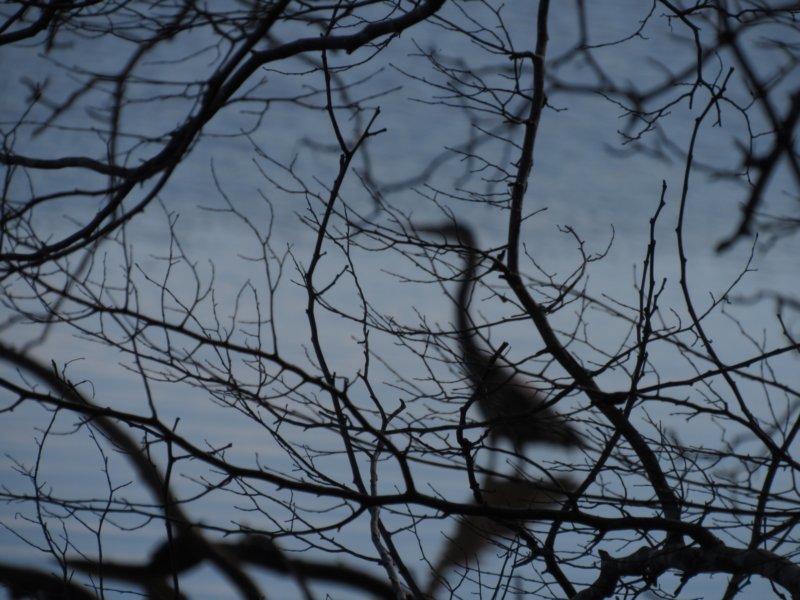
 The second of the two trails out there is the Chief Black Fox Trail. A loop as well, it's a little over twice the length of the first, and again, no map to show exactly where it led. After another great read of the history of Black Fox and the area, we set out down the trail, marked with red posts this time. The land here was completely cleared of underbrush as well, which were it not for the red markers, made it difficult to discern where the trail was, as leaves covered much of it. Lulu attempted to climb a slanted tree after a squirrel, amusing to me, but frustrating to her at her lack of tree climbing skills. Past the loop split, some tall pines began to mix into the otherwise completely deciduous forest thus far. The added straw also didn't help in locating the trail, but it's not like there's even a remote possibility of becoming lost here. The Dr. Bill Sims Trail ran in parallel for a while, before turning uphill past a grassy meadow where we spotted a plump chipmunk out for a warm January stroll before he escaped into his den. Through this section and continuing toward the end, I noticed a number of the red markers seemed to have been chewed. The obvious tooth marks kind of ruled out a weed trimmer of any sort. Back downhill, the trail made a hairpin turn through more grassy area, with views of the river finally coming into play, as well as open views of the golf course. Water drainage problems forced us onto the greenway for a short bit, but it didn't save me from a misstep back on the trail into ankle deep mud. Past an open area with a great view of the water, and a view of the highway 65 bridge in the distance, we again had to abandon the trail in favor of the greenway from standing water, and at times, vice versa. Stopping at a fallen pine to photograph some interesting bark patterns, I noticed a neat little straw burrow built on the side of the path, rounded to the point where it looked like water had shaped it. I caught sight of movement in the water close to the bank, and as sneakily as I could, Lulu and I ventured close enough to snap some photos of a great heron's shadow through the thick trees, and also of some egrets well out across the river. An attempt to photograph a large white heron close to shore resulted in us spooking it unfortunately. Ahead, and back on the trail, a more significant stream, the actual runoff from the lake we found on the Chief Doublehead Trail, forced us onto the road briefly and into another small patch of woods, where the trail became confusing again. Here, three different paths were marked, and I had us continue with the one we were on until it suggested we turn and loop back. Noticing the markers going forward, we hopped another water hole and kept going. The gravel on this segment suddenly ended, though the markers continued on. I concluded that this was one of the second set of trails still under construction, so we turned back, taking the true loop part of the trail where we left off. Closer to the trailhead, we took another spur to complete the loop, and with Lulu tiring, it seemed great timing to arrive back to the car when we did, and make our way home.
|