|
[back to 2015 Index]
 Little River Canyon National Preserve, AL:
October 10, 2015
Martha's Falls Trails, various overlooks
Distance: 2 miles
[View Photo Gallery]
Four years since our last adventure, and double that since we lived in the same town, close friend and fellow Muddy Boot Clan member Randall and his wife Leigh moved practically next door, and we've wasted no time catching up. Robin drove up on what's becoming a rare Saturday off, and the four of us set out for Little River Canyon National Preserve on a cool morning in search of early fall colors. Torrential rain had fallen the night before, and we hoped it would be enough at least in the short term to alleviate some drought stress and brighten up the waterfalls a good bit as well.
After an initial stop at the welcome center, where we inadvertantly showed up in the middle of a half marathon event, and ran into Pete Conroy from Jacksonville State University in the process, we ventured over to the falls, away from the crowds for the most part, enjoying early reds and yellows mottled the riverside and surrounding hills. The waters were noticeably silty from the recent rains, and definitely higher than normal volume for this time of year. Despite the cloud cover, neither Randall or myself could get our cameras to work properly in the cloudy conditions to achieve the milky look of the falls we were after. Robin took some nice shots of one of the smaller cascades upstream I'd been ignoring. In terms of scale, this is by far the grandest place I've ever taken her; it's a far cry from some of the waterfalls and vistas of Birmingham. Little River Canyon is a far cry from anything else in this state for that matter. Nowhere else is comparable with regards to canyons, and perhaps only Mount Cheaha rivals the vistas in terms of scenic quality. As we were walking back toward the parking area, Randall asked about trail options. I mentioned the two popular steep ones, but also a newer trail that I'd yet to see that we were walking right past. I cautioned I knew nothing of the terrain, and the fold up maps had yet to be updated to include the Martha's Falls Trail. I could remember chatting with someone my last visit when I visited with mom who approximated it at about three quarters of a mile one way. In reality, it would end up just a hair under a mile, and excluding the trail at the Mouth Park, is the easiest trail in the preserve. The last leg of the hike, though, would prove to be a bit problematic.
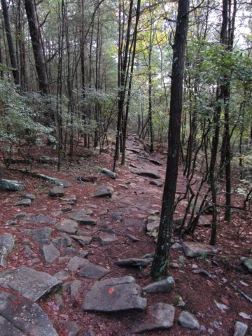 Martha's Falls Trail set out from an odd spot at the back end of the parking area, with no real formal trailhead or kiosk notating it's existance except for a small sign. In hindsight, we could have driven down the road a piece to the other trailhead and saved time, but we would have missed some splendid scenery along the way. The mature forest at the beginning of the trail quickly changed to that of a much younger forest, the ground muddy and rutted from overuse and erosion. Just as quickly, though, we moved slighly back uphill through long slabs of rock for a path and open canopy. Rounding a bend, the water roared below, out of view. We stood for a few minutes and looked off the fifty foot bluff here, reminiscent of Sipsey, as if Sipsey were the only bar a hiking trail were weighed against. But Sipsey is a bar of sorts. It was with Randall in 2006 where I had my first taste of Sipsey's magic, and I've never looked back. Back in the midst of a mature forest, where the leaves matted the ground like an oil painting, we wandered slightly downhill, crossing a small but persistent spring that fed a six to ten foot waterfall. I tried in vain to find a way down to photograph it, but every angle required a little risky manuevering. The trail wandered gently back up on the rocky ledge before crossing a dry draw, and a trail split. Randall and I took the route closest to the edge, stopping to attempt to explore a small shelter, but once again the terrain didn't provide easy access. The ladies circumvented it, wandering through a small grove of young pines and beautiful club moss. The rocks became looser and the terrain more uneven as we climbed in elevation, with a fantastic, if mostly skewed view of the canyon and some rapids rushing by below. What the trail lacked in excessive elevation gains and losses, it made up for with it's persistent undulations that provided a good workout still.
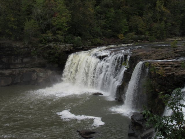
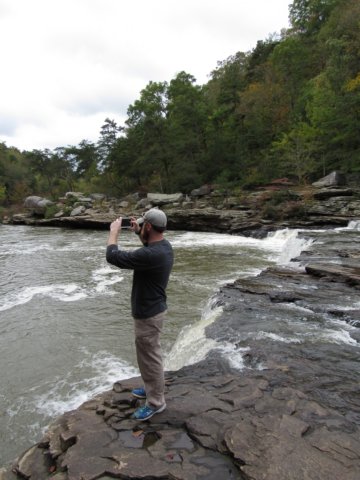 The next bend offered a more open shot, and I managed to snap a photo or two of a small cascade manuevering around a large boulder far in the river below. The mix of yellows and reds with the pines here were vibrant and a true highlight. Unsure how much further the falls were, I jogged ahead. Knowing we had to be close, the temptation to keep pushing and see the falls was tantalyzing for me. The forest wandered downhill a little through more mature woods and slick rocky sections before opening into a glade like area that may have been used as a parking area at one time. A trash can and sign for Martha's Falls was here as well. The gravel road leading off to the east assuredly ends at the new trailhead off of highway 35. The route then went very sharply downhill through some large rocks and a fast flowing spring that cut through it all. I knew the falls were close, but I also knew there was no way Robin would attempt this, and I'm glad she didn't considering how sore her knee was. After some scrambling and careful manuevering, I ended up back on Little River, the falls nowhere in sight. At first I thought the small cascades just upstream were possibly what I was searching for, and then considered the trickle sprinkling off the hillside from the stream passed just before. While the scenery was nice, I was a bit disappointed until a fellow hiker pointed out the falls downstream, blending almost seamlessly in with the rest of the river. Before I could reach the falls, though, I found Ladies Tresses Orchids, nestled amongst goldenrod and fall asters. Not a place I would have searched for these, but wiill be something I consider in future adventures to be on the lookout for. I sent Randall a text that I'd made it, and walked down to the falls, about ten feet high, stretching the width of the river. Both banks on either side were undercut, with a high bluff on the side I was on, a cave almost hollowed out beneath it. Several other little springs wandered from the hillside to join here with the river. As beautiful as this place was, it was still a decent hike to reach what's a popular swimming hole in the area.
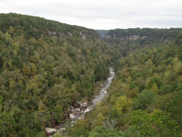
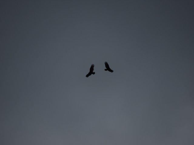 I wandered back to the trail's end, and noticed Randall descending. He mentioned that Leigh and Robin opted to stay above, and so we ventured back to the falls and enjoyed it for a little bit before making our way back up the hillside. As we were ascending the rocky section, Randall remarked this reminded him of a scene from Last of the Mohicans. The ladies had already started to head back, but we caught up soon enough. I stopped to pick Robin a bloom from “hearts-a-bursting-with-love”. Also on our return trek, we walked past a large patch of partridgeberries, though no one would taste them. Needing to head back to check on pets, I asked if they're sure they didn't want to see a few of the overlooks, since that's truly why people venture to the place, with Little River Falls as almost an afterthought. “Wow me,” Randall said, and off we went to the Little River Falls Overlook for a late lunch. Skipping the next few overlooks, we stopped at Crow's Point, with its nice vantage point downstream, plus views of the homes on the far ridge, and an opportunity for great shots of the river and cascades below. We spotted two caves across the way not far from someone's house. The cave to the left appeared to have some kind of iron seep in it. A large nearly square section of the mountain had slipped off as well, hugging against a tree. I can only imagine the kind of sound it'll make when it finally slips loose to the canyon floor. Stopped at the next overlook, which offered views in both directions, I grabbed some closeup shots of the canyons cliffs, as well as hawks or vultures flying in unison above the far bluff. Grace's High Falls was next on the list, but the small observation deck was crowded and the viewfinder missing, which was unfortunate, as it's the tallest above ground waterall in the state. Continuing on to Eberhart Point, our final stop, Randall commented on the unusual mushroom rock, a landmark feature sitting in the middle of the road. At the overlook, Randall and I ended up climbing the railing for a better view of the canyon, with Robin and Leigh shaking their heads at the “boys being boys”. A spur trail led down to an even clearer view of the canyon, but the ladies were ready to go, so we decided to save that for another trip, and headed home.
|