|
 Davis Creek/"secret canyon":
February 16, 2013
Bankhead National Forest, AL
Distance: 4.25 miles
[View Photo Gallery]
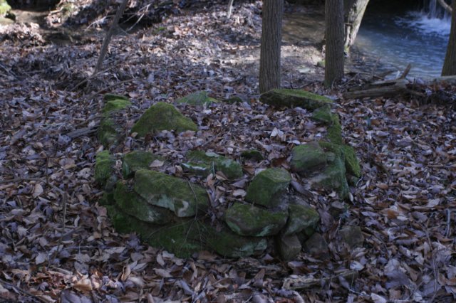
As I do with most of my off trail adventuring, I set this up to be an ambitious hike. Roughly 8 miles long, I intended on hiking the lower half of Davis Creek before heading down river, exploring what I’d dubbed the secret canyon, and several more miles of river walking before ending at Hurricane Creek Falls. Getting there involved a hiccup or two, from initially missing the turn off on otherwise unmarked roads, to dealing with some pretty muddy spots. We dropped one vehicle off at the end point, which conveniently was on a bit of a ridge that would also allow for an earlier exit from the canyon, if needed, and then made our way to the starting point. Little did we know the adventurousness would get started a bit early for us.
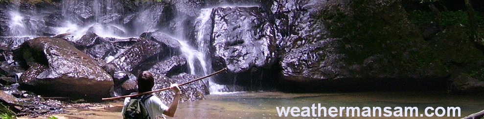
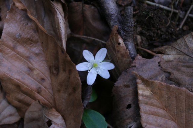
About half a mile in from the other entry point we found the road completely blocked by a fallen tree. I had a jeep, but the steep terrain on either side wouldn’t have allowed for any kind of circumnavigation. There was only one thing to do from this point: just start walking. The road went uphill and around a bend, with a great view into the valley to our right, very steep slopes but little in the way of rock outcroppings here. Soon we were at the gate, and I immediately wanted to get off the road and down into the canyon, but David suggested we stay on the old road for a bit to cover another quick half mile or so to help on time, as we ended up beginning this hike rather late in the morning for such a long trek. I’ve no qualms of hiking out in the dark, but many of my hiking friends don’t care too much for it, so onward we went. There were old seed pods and last year’s dead foliage from various wildflowers all along here, but I couldn’t quite decipher what they were. The tree canopy changed from mixed hardwoods to a more open area with tall pines that went sharply uphill for a bit, almost cresting the ridge here just to the left of the road, before descending and leveling out into what may have been a turn around at one point, but is now a large mud wallow for pigs. Their odor permeated the air, and I was certain we’d spook one out of the tall grass around, but we never did. I tried following the road a little ways past here, but the deadfall and undergrowth was too much to deal with. We opted then to strike out downhill into a drainage in Davis Creek, steep in sections, with lots of weird little piles of dirt and stone here and then. They seemed much too far from a water source to be old whiskey stills, but the land almost seemed much too steep for them to be embankments where people would have parked vehicles many years ago. We found lots of sedge blooming as I usually do this time of year, though I was still hoping for more wildflowers on this trip considering some early signs of wildflowers we’d seen in Bankhead a few weeks back. The land began to flatten out here and I could hear some rush of water, which turned out to be a small falls about 3ft high, with the remnants of an old whiskey still just to the side of it. Just downstream was a large metal section of something, only mildly rusted, almost as if the running water has preserved it to some degree. Passing another small falls the underbrush disappeared here and the land flattened, revealing a gorgeous canyon and about a 60-80ft shear drop to the bottom. I spotted a large beech tree with a carving that read “JCR MAY THIRD, 1915” on it. Old carvings have always been one of my favorite things to find in the forest, and this was one of the oldest dated carvings I’d seen. I knew we had to find a way down into this canyon, and I spotted a very steep access point, that would amount to a slide and probably a game trail or escape route for wild pigs. It was marked with some blue flagging, and while David looked at me like I was a bit insane, he offered to head down first. I decided the descent was worth filming, and ended up losing my footing, careening past him at kind of a midway point and slid a good 30ft before managing to grab a tree and stop myself. It was a pretty wild little ride that busted a knuckle up pretty good but otherwise did me no damage. I ended up standing on the a very steep slope that led down to an intermittent stream; the view upstream revealed a very narrow low flow waterfall with an undercut shelter. At the point where the water hit the ground was a large round tilted rock that looked like an off kilter dining room table of sorts and almost as if it were placed there. I crossed the stream and tried to gain ground uphill for a better photo angle on the falls, but it was tough work. After heading downstream and finding some hepatica, I skidded down another section of hill and crossed the stream again and met up with David. We climbed back to the bluff line and went around the bend headed toward the big falls at the top of the canyon where we found a kind of twin falls with a narrow almost island of sorts between the two that sported a single large hemlock tree that grew almost dead center of it. I climbed up the island and the first little rock ledge and walked around a bit. The view was pretty great from here, and made David appear a bit small in the landscape by comparison. Continuing on we found waterfall #5 on the day, a sliver of water running down a crevice before tumbling over a steep stone stream type area here. We stopped to admire the color and softness of some moss that completely covered a large boulder; it felt like silk! The falls at the head of the canyon were also visible from here, falling about 50-60ft into a small plunge pool before navigating it’s way through a boulder strewn stream. Though nice, this canyon’s waterfalls paled in comparison to some of the other canyons I’d seen in the canyon just a few weeks ago. Walking downstream was quite a task at times, which included navigating large dead fall while trying to avoid stepping on and squishing a large colony of club moss.
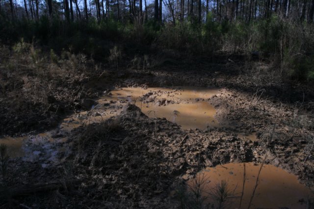
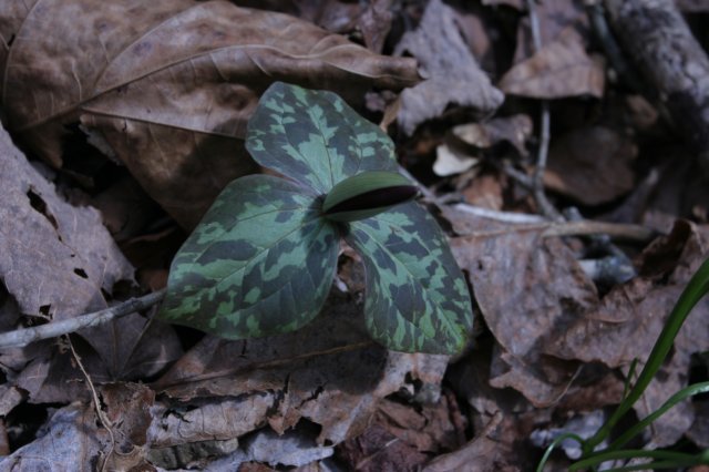
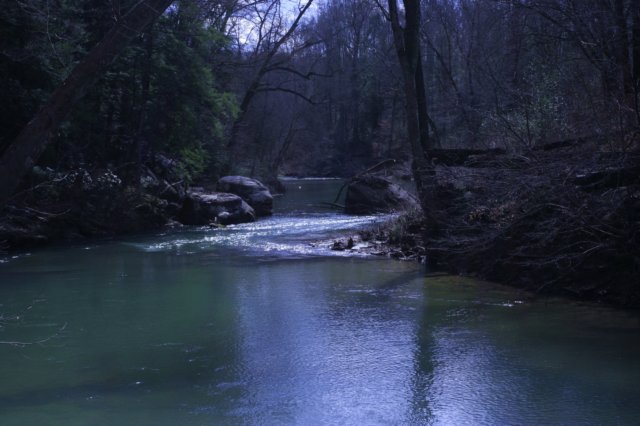 We stepped over a bit of an underground cascade, which was really just the last little seasonal falls we’d passed as it reemerged shortly before joining the larger stream here. The canyon began to flatten out a bit and rue anemone and hepatica were both in bloom, little dots of white appearing here and there. I found another arborglyph, with some markings that may have been letters or symbols maybe an “s” and a “v”, but they were quite faded and hard to read. There were some decent sized trees in this little side canyon, and several of the large hemlocks had really nice buttress roots on them. Soon the hemlocks began to mix a little and then change over to almost all hardwoods, a sign we were getting close to the main channel of Davis Creek. Most of this land here had been clearcut at one time; it is only the canyons now that one finds the beautiful hemlocks growing in for the most part. With the loss of hemlocks came the rush of undergrowth back, and we stayed close to the creek until I spotted an interesting set of boundary marker trees and went over to investigate it a bit. I like finding waypoints and bearing trees in the forest. In the event one’s GPS unit ceases to function, one could use the information gleaned from these to locate oneself on a map. That was no issue today, so we pressed on, stumbling across an old game trail that we followed for a way. A small 6ft cascade trickled down from a tiny little feeder stream before the game trail split. Tired of the underbrush, I headed uphill while David stayed low. I don’t usually like splitting up on trips like this, but we were walking parallel to one another, and often, I could see him a good 100ft downhill in elevation from where I was. My trail finally dissipated, and I shimmied back down to the creek. What a view from up top, though! Something began to smell kind of foul [like pigs], and we passed what could have been a spring fed channel here, but likely also doubled as a pig wallow these days. The underbrush here was thick; we had to be close to the junction with the Sipsey River. A very faint game trail picked up again, and we entered what looked like a grove of trees at first, and then I realized this was mature privet, almost 15ft tall! The trunks were a good 6-12 inches on some of these things. I told David sarcastically that someone else could yank these guys out, invasive or not. All along here trilliums had sprouted, with a few almost ready to open. I eagerly await these awesome little wildflowers every year; it is no secret they are one of my favorites. We meandered through the privet as best we could for a while, and while we couldn’t see the river, the compass readings showed we were headed south, so we knew we’d passed the junction of Davis Creek and the Sipsey River; the underbrush was just way too thick to breach to see the junction itself. We finally came across some privet small enough to pull and David couldn’t help himself, and yanked some of them up, wedging them in a tree branch so they couldn’t root again. It is a never ending battle with these plants here. The terrain was quite steep uphill away from the floodplain area. We followed as close to an old game trail here as we could before pushing our way up close to the river just to get a view, and what a view! It was so quiet here, so very wild.
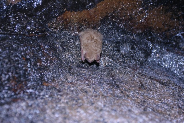
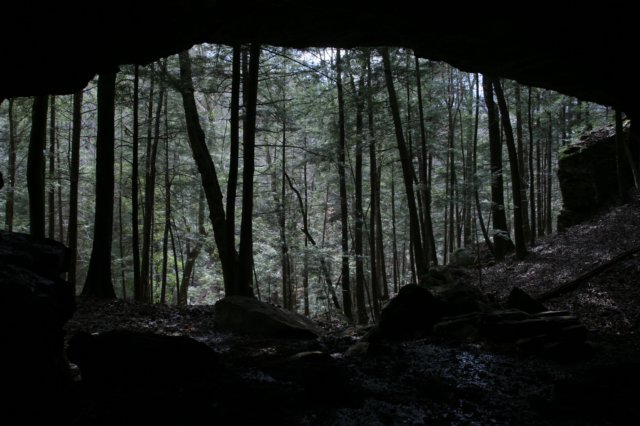
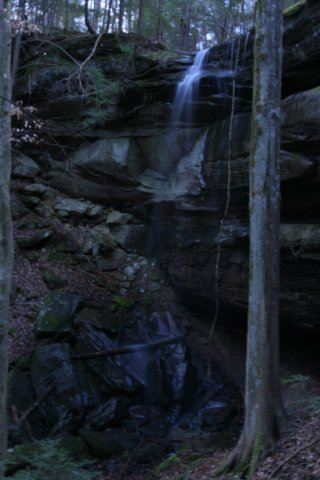
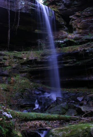
 I climbed down on to a large rock and I attempted to fish out a sign from the steep riverbank that had washed up, but to no avail. We sat here for a bit and shared stories before continuing on. We crossed a small intermittent stream here that I tried to follow upstream for a ways to take a photo of the small waterfall, but it was impossible to see the falls in the photo for the underbrush. The game trail here kind of disappeared again, and we passed other wildflowers beginning to crop up, such as trout lilies and Virginia bluebells. Despite the hemlocks around we had to push through some underbrush here to keep our heading. I could see a bit of a drop up ahead and knew we were coming up on what I’d called the secret canyon. Why the secret canyon? I could find no information about it, and it is a stream/canyon with no name, seemingly unknown. I wanted to explore it! I think we both knew at this stage that the prospect of hiking another 4 miles downstream and then up to Hurricane Creek was fairly unfeasible. David was satisfied with the hike, and wasn’t terribly sold on heading up this canyon on a gamble that it would use a good hour or two of daylight, and also possibly not yield a way out of the canyon, which would put us out close to dark, if not after. To get our minds off this, we decided to climb to the top of this large arm of land that separated the river from this unnamed stream, which oddly featured a boulder prominently at it’s peak as if it were purposely placed there. He shared some dark chocolate with chilies he’d brought with him [quite delicious], and we got the map out to analyze our options. Comparing what I knew of other canyons in Sipsey/Bankhead and how the terrain/bluffs behaved, I decided there was a reasonable shot at us finding a way out of this place. We were technically closer to the first vehicle we stashed than backtracking anyway, even if I didn’t necessarily know an exact route through the woods to get there. We finally got going again, and I stopped to photograph what looked like old carvings on a beech tree, but I’m not sure what these uniformly dashed lines stacked on each other were. This was a wide stream, with ample water flowing down it, and seemed incredibly promising for a nice waterfall at the head of the canyon. As with almost every off trail hike I do here, it required crossing the creek multiple times because the easier terrain was suddenly on the other side. There were lots of interesting reflections in the water, bare trees and the blue sky; it had been a good day for photographing reflections all together. This canyon was nearly filled with hemlocks and is a place I would love to go back and explore more in depth, perhaps even camp along the river itself there. We passed a kind of lazy stream flowing in from the other side, and the map didn’t show anything significant, but something felt right. It was like I could almost see something there, but couldn’t put a finger on it. There was no easy way to cross here, but I finally made it without too much hassle. This little side venture was a solo effort on my part, and as I didn’t want to take too long, I made haste up to the head as quickly as I could, stopping only to photograph a very rich green colored cranefly orchid leaf. I stopped a bit awestruck as a 70-80ft waterfall appeared suddenly with one of the largest shelters I’d seen in Bankhead. Just a truly great scene! Had there been more water I’m certain the waterfall would have been in much better flow, but it was the size and depth of the shelter that wowed me here. I followed the same little narrow game trail back down to the river and shared my discovery, and I think David was kicking himself a bit for not venturing to see it. I waited to cross until I found an old tree, although rotten, instead of risking getting my shoes completely soaked. He would make the next big find, though, after a crazy bend in the stream here, spotting a dark spot on the bluff line on the other side of the creek. This time it was his gut instinct that was correct, as this was more or less a cave than a rock shelter. A shower of water fell from inside the shelter, ice cold, and the large drops felt wonderful, even on a cold hike. As we were beginning to leave I decided to just turn the flash on and start taking photos of everything, and noticed one spot didn’t reflect like the others, and discovered there were bats here! It had been some time since I’ve seen bats in the wild, outside of their acrobatics at dusk in search of food in my neighborhood. It was good to know that there were some places that the dreaded white nose syndrome hadn’t reached, and hopefully won’t. We also photographed an old casting from where a log had eroded out, leaving instead a hollow tube and bark patterns instead of a petrified log.
 We headed on upstream, crossing the stream a few more times because of large masses of dead fall that forced us to climb or go around, leading eventually to another stream junction. I knew the route out was to the right, but that the main waterfall of the canyon was straight ahead, so onward we went, dropping our packs at the junction here to expedite travel a bit. I ended up crossing the creek and dealing with a lot of deadfall in order to get a few great shots of the falls, and true to form, this waterfall had a dead tree in the photos that just wouldn’t get out of the way. This waterfall came to be known as Slippery Rock Falls, after a stunt I pulled hopping about 4ft out to a moss covered rock in the center of the plunge pool, saved by only a tiny spit of sand from being completely soaked. It didn’t quite knock the wind out of me but I was certainly sore to say the least. We walked back to the junction via an old road, stumbling across a downy woodpecker feather, which was pretty cool. As we still had a little time to spare, I made quick work to the head of this other little canyon, which didn’t look like much on the map, and this time at least, didn’t have much return on our time investment. A two tiered waterfall slipped quietly about 10ft each down to the canyon floor, though the upper falls did have some nice little ferns growing behind it. I simply walked across the stream itself, just an inch or two deep, and we walked back down until the land sloped down enough that we could climb it. A rather slippery climb, and one that required many small breaks to catch a breath, but we did finally make it up to the ridgeline, finding some old flagging along the way. There was no discernible path, but from the map we knew all we had to do was parallel the side canyon we’d just hike and then turn a bit more due south and as straight uphill as we could stand. At times sections of an old road bed would appear, and we’d walk that, and other times the heavy underbrush slowed forward motion to a crawl. I found a large grouping of cranefly orchid along our march here, before finally reaching the road we’d driven in on, although we were about half a mile down the road from the vehicle, and our ticket home.
|