|
 White Oak Hollow / Big Tree Loop:
January 27, 2013
Sipsey Wilderness, AL
Distance: 9 miles
[View Photo Gallery]
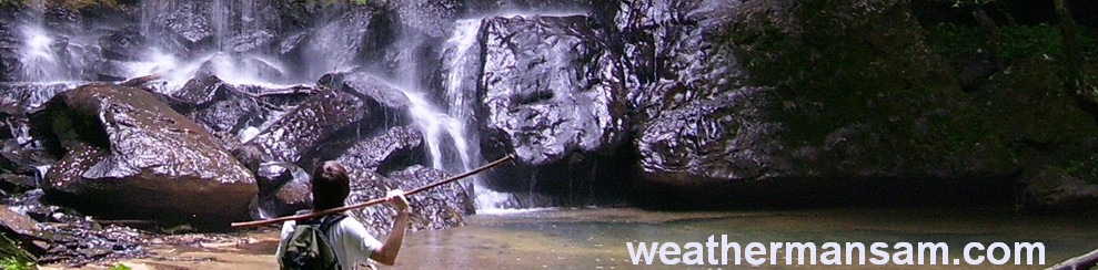
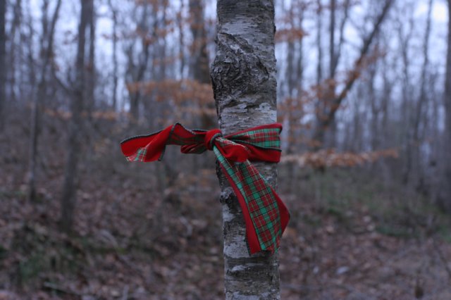
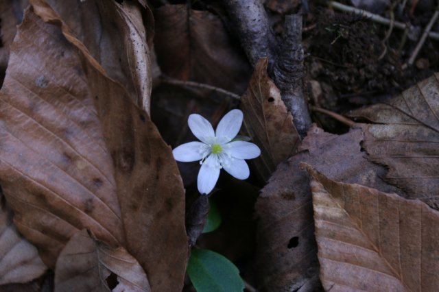
On a cool, overcast Sunday, I decided to make for what I considered a long overdue return trip to the big tree in Sipsey. It had been about a year and a half for me, but it had been several decades for David, a new friend I'd met at a Wild South get together a few weeks before. Also up for some adventure this trip was Mark, who had yet to see the big tree or this part of the forest at all. This loop is a personal favorite, and I had little doubt the others would enjoy it as well. Despite the recent heavy rains, the winter water levels were low at Thompson Creek, as were the number of vehicles. I’m not sure I’ve seen so few cars there before. We made quick time of the section to the White Oak Hollow crossing, dealing with some occasional sprinkles. The water level was lower than I expected, after a very easy dry crossing on rocks, we took the route upstream on White Oak Branch a number of sharp-lobed hepatica in bloom. The water here was quite clear, and calm in sections, making for some neat photos. After a brief confusion due to some down trees, I got us back on the right track onward and upward, stopping to look at quite a few little groupings of cranefly orchid. I’ve come to the conclusion it’s the most common orchid in Bankhead. I’m not sure there’s anywhere I go that I have not found it, if I were looking for it. Reaching the ridge, we came across a sometimes familiar, but unfortunate sight in the wilderness area: flagging. Except here, someone had taken thick Christmas-like ribbon and tied to the trees. We descended quickly into West Bee Branch, skipping the first few falls because of low flow. With the tornado damage still in place, I had a feeling time was of the essence, even though we’d arrived and started out early on the exploration.
The area where one drops down into West Bee was exceptionally muddy, and a bit dangerous. It’s only a matter of time before someone falls and is injured on the dead tree used as a ladder or handholds to descend a really slick area. This time, someone had also tied a rope haphazardly across the water here that provided no assistance or true support. I dismantled it, and we all crossed with no issues. I did have us take the time to explore a little seasonal falls up the little cove from the creek we just crossed. Heading that way, I spotted something I’d never seen there before, a kind of needle’s eye, or so it appeared. After a steep, slick walk to it, I found a long tunnel, except in the center of this tunnel was a crevice that dropped approximately 30ft to a rock floor. I could see where thrill seekers walked a narrow interior ledge to get from one side to the other, and also found their trash left behind, a half empty water bottle. Tempting as it may have been, I had no rope nor any desire for daredevil stunts this trip. While David and I were exploring this section, I noticed Mark had disappeared. We found him exploring the falls, which was flowing better than expected. The bluffs here are probably 80ft high if I had to guess, possibly higher. Years ago, I stood from the top of this waterfall and stared out down the canyon, and what a gorgeous sight it was! It's a great area from any perspective, and we spent some time studying some very old trees here and the large boulders, and certainly the waterfall. After a snack, I opted for us to hop back over and continue following the social trail, which runs alongside some impressive bluffs, which I knew Mark and David were enjoying. Before I could do so, though, someone hollered out “Hey, weathermansam!” within earshot of my fellow hikers. I’m not sure who the man was, or how he knew me, but I gave him directions to the same spot we were headed, the big tree. I found the experience both weird and amusing at the same time. We crossed in a shallow spot just downstream of boulders so covered in moss they were entirely green, with small ferns and partridgeberry hanging from crevices. I found some very early foamflower starting to sprout, one of the few wildflowers I saw that entire day. Back up on the social trail, I took time to explore the tall rock bluff here as I always do, finding a very bright red fungus growing on an old tree and what looked like very weathered writing or carvings on the rock face just above a small spring, but it was quite illegible, if it were anything at all. We all took turns taking photos of the big rock here that looks like an alligator’s tail; it has a very distinct scale pattern that stood out in the forest here. Mark pointed out a different rock formation that appeared to be sticking its tongue out at us. It briefly rained on us again here, but not enough to break out the poncho.
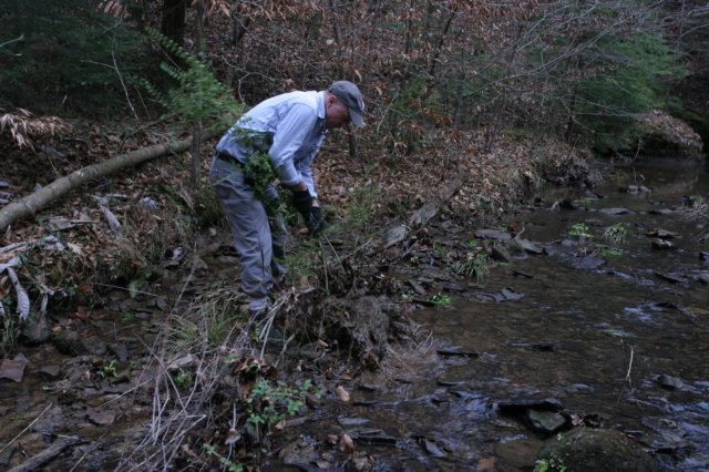
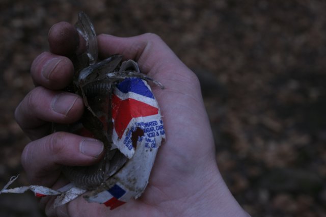
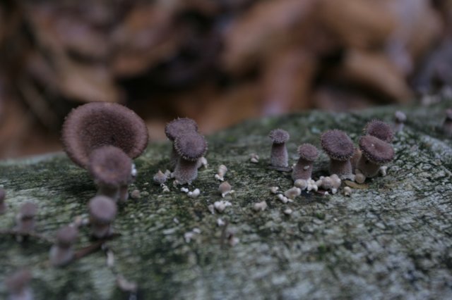 Crossing west bee branch proved a little tricky, as the water was just deep enough to cover boots, and wide enough to make it a little tough to bound across. I found a few high rocks to cross on, and we got across mostly dry. Once across the creek, I decided to check out a well used campsite here for trash. The trail around the backside of the camp had a plethora of fungi in all kind of colors, as well as some liesegang banding on a rock overhand with a cool tree root that clasped over the side. I found and shared the “Puck” arborglyph, and we stopped to photograph some boulders across the creek that appeared to roll like ocean waves. After some photos of rattlesnake plantain, the others hesitantly followed me across an old log that bridged a small drop between two rocks, the easiest route across at this point. We wandered back uphill and down again, reaching the junction of east bee branch with west, and taking down yet more Christmas style ribbons from a tree here. A huge boulder sits at the junction of the two bee branch streams; if you miss it, you’re not studying your surroundings hard enough. Following the well traveled route, we shortly found ourselves in pretty much the same chaotic landscape I’d seen my previous trip here, though it was very obvious people had been working to clear the trail. Mark and David took a break, and I scurried off uphill following a series of trail blazes that ultimately led to nowhere, although it did provide a great vantage point of the damage wrought by the tornado a few years back. After a good snack we took the lower route, per my suggestion after scouting, remembering how cumbersome and slow the trek was the last time I came through. There was still plenty of ducking and climbing, but it was pretty surprising how much work had been done. This is not an official trail, so it never sees maintenance by the forest service or the volunteer organizations who work to keep paths clear through the wilderness area here. The trail dipped down and crossed a seasonal drainage, and we could hear a waterfall, but my knee was beginning to give me a little trouble and I had little interest in climbing to see it. David spotted some privet growing in the stream bed here, and we fought our way through the scrubby bank to get at it. A nasty invasive little thing, Mark and I watched mostly as he manhandled it out of the ground and wedged it up in a tree to die. We continued on, but then found a split in the trail I was unfamiliar with. After a little maneuvering to get across the creek here, we discovered a very large and pretty awful campsite, with a lot of garbage, fire ring, and just an absolute massive pile of firewood. We spent a good 20 minutes picking up wet socks, lots of cigarette butts, tin foil, tin lids among other things and naturalizing the site. It is rare that I lose my temper, especially in the woods, but I did this day. David crossed the creek again and climbed the hill to scout out the trail ahead while Mark more or less just got out of my way as I threw rocks and limbs about, scattering them as much as possible and making it as hard as I possibly could for someone to reestablish a site here. I was chided a bit for throwing logs in the stream, as it will just add to the log jam downstream, but I was certain a future rain would take care of that jam, so we went on.
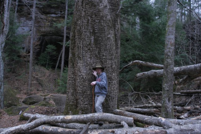
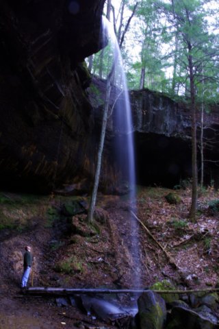 I found cranefly orchid sprouting on an old log here, something I’d only ever seen in one other spot in Bankhead, on Beech Creek. It’s fascinating to get a glimpse of the orchid in that stage of its life cycle. Crossing the creek with the others, we went uphill only to find the trail disappear. I knew we weren’t far from the tree, so I had us press on almost straight uphill where after fighting through a lot of underbrush we came across the old trail again. To my surprise when we reached the Big Tree we found people. Most folks seem to be coming now from the Borden trailhead, which is where these people said they were from. They hung around for a little while, but eventually went on their way. A crowd here makes me uneasy; there’s something about this place that makes you just want to enjoy for yourself. I consider the canyon a kind of sacred place, and such places require a level of peace that you can't get with a crowd. Much progress had been made on getting the fallen beech tree away from the base of the big tree now, and it rested comfortably on the large yellow poplar roots instead of against the trunk. The old wounds had begun to fade in color and seemed to be mending well. Both of the waterfalls were flowing, making for some great photography sessions. David found the route up above the falls and had me snap some shots, using him as a size reference against the falls. We collected more trash from the area, a lot of broken glass right at the base of the big tree, and cleared out a fire ring with batteries and other assorted trash about 15 feet away in what’s becoming a popular little spot to put a fire. After braving the mud a bit and enjoying one of the falls, we cleared yet another fire ring at the other waterfall here; this spot always seems to have a new fire ring each time I visit the area. It’s always been an unspoken ‘rule’ that you don’t camp in East Bee; it seems many people are not aware of this tradition, or don’t understand the importance of being low impact in sensitive areas. I was happy to see the little rare fern appearing to make a comeback beneath the rock shelter nearby, certainly helped from all the downed trees and reduced foot traffic.
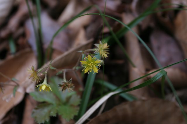
 After a lengthy break for lunch, and seeing we were short on time [the others wanted to be out before dark fell…that’s always mattered little to me], we made haste; my knee, however, had other plans. I had not been in that much pain with it in some time, and I just sort of hobbled along. To a degree, it also didn’t make much difference to me if the others left me behind a bit or not, as I know this part of the forest quite well and I wasn’t depending on them for a ride home at any rate, either. I stopped to check on a geocache set up in honor of Jay Hudson, and found it missing. I'd planned to remove it, as per wilderness guidelines and a recent effort by Wild South and the Forest Service to remove all they found within the wilderness area. With the amount of trouble we had coming in, we decided to stay the high route, off whatever trail remained here, hugging the ridgeline in hopes for an easier hike. It wasn’t. knee deep in leaves at times and whip like underbrush made it a bit annoying to get through, and numerous climbs over dead trees made my knee even worse. David offered me a banana on the off chance I guess that the potassium would help some. After a rest and a snack, we made it back to the east and west bee branch junctions. We’d originally considered going back the way we came, but I didn’t want to deal with a lot of uphill travel with my knee, so we opted for the slightly longer route, and the way I’ve always preferred, making a loop trip instead of backtracking. Even with the water low, I suspected the crossing of bee branch near the junction of the Sipsey River could be problematic, as I doubted the fallen tree I'd used in the past was in any kind of shape at this point to venture across. I’ve always really enjoyed the stretch of canyon between the junction of east and west bee and the river, even with the one or two large campsites it’s always had a very primitive feel. There were sections through here where fresh deadfall blocked the trail. I spotted an “x” on a tree that I had not seen before, possibly an old property marker. At one of the large campsites, we stopped briefly and picked up some trash, but none of us really had much space to store more in our packs. The tree at the river junction was not worthy of crossing, so Mark and David did a quick dance across while I opted to ford it barefoot. Between here and the Saltpeter branch we made good time, only stopping here and there at overlooks or a spot to get down to the river and rest my knee for a bit. With time becoming an issue we decided not to explore the Saltpeter Falls area, which was unfortunate. It's a unique and pretty spot that doesn't seem to get a lot of visitors. My knee pain finally began to subside here, a welcome relief, and something that would help us move a little faster. The warm winter caused some barren strawberries to pop up more than a month early, with toothwort also sprouting in numerous places. We didn't come across a single person at the eye of the needle area, an eerie feeling. However, signs of human occupation were certainly around: burned tin cans and a two young hemlocks completely stripped of their foliage for someone to make a bed from. The price paid for being the most visited place in the forest is that it is the never ending whipping child of abuse at the hands of careless visitors. Regardless of how irritating situations can be, the beauty of the rock garden and rush of the river eased my nerves. We stopped shortly to take it all in, but with dusk beginning to set in they wanted to march on, so we did. The clouded sun approached the tops of the tree as found ourselves at Auburn Falls. Not wanting to be out on the trail at dark, David decided to trek on to the vehicle while Mark and I browsed the area around the falls. I was a bit uneasy about it all since it’d been many years since he’d been here, even if it is near impossible to get lost on this stretch of trail. We decided to make an attempt to catch up with him, but that was kind of futile. He sets a pace that’s much faster than me on any given day, let alone me with a bad knee. As we made our way through a section here where many trees were cleared I spotted something I’d yet to see in bloom, or even be aware of it’s existence in the forest at this location: the winter leaves of puttyroot orchid. I vowed to come back here later in the spring in hopes of finding the spot again and the plants in bloom. The last bit of walk out here ended up a very quiet walk, a bit reflective of the day’s outing, I suppose, and an appreciation for it all. We found David waiting at his vehicle, and with dark upon us, set out home.
|