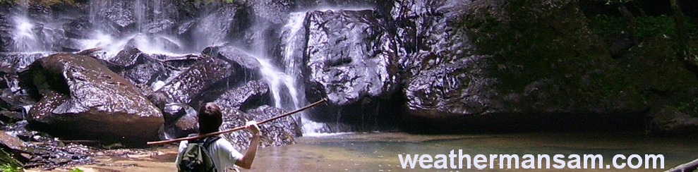
|
 Upper Davis Creek:
January 19, 2013
Bankhead National Forest, AL
Distance: 8 miles
[View Photo Gallery]
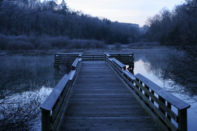
Davis Creek had long been a place I wanted to explore. I’d seen just a few photos of various waterfalls, and it seemed easily accessible. I certainly didn’t know it’d become a bit more than I bargained for, but that’s all part of the adventure. I approached this hike differently, staying the night before at Brushy Lake [I didn’t really count this as a camping trip]. I was already in Moulton that evening for a Wild South get together, and decided to save myself the gas and just camp out in the back of the jeep somewhere close so I could get a jump on the hike in the morning. I completely underestimated just how cold it would get [the mid 20’s], but the mist from the dam coated everything in ice, with fog billowing up from the base of the dam and creeping ever so slowly across the surface of the lake. It was absolutely gorgeous. I made my way down to the dam for some photos, and passed several people camping where they shouldn’t have been, including a rather large boy scout group camped next to the bathhouses, which were locked. After musing at this a bit, I made my on over to the Davis Creek area.
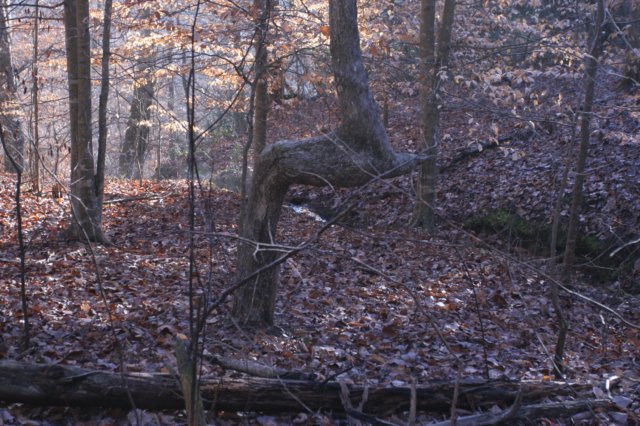
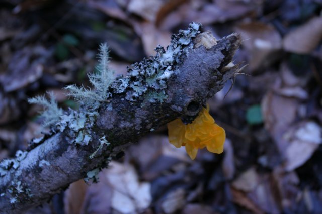
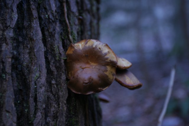
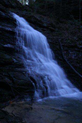
Instead of taking the usual route in like many seem to do off of highway 33, I opted to go in through an old forest service road marked on the map that would put me about midway through the area I wanted to hike to make a decent loop of it all. What I should have known going in that these old roads are sometimes not very easy to find, and in this case, there were a multitude of roads to choose from. After studying the map for a bit, I just decided to pick one, and set off downhill with hopes I’d find some significant feature to verify exactly where I was. The gps unit I brought along for the hike wasn’t the one I usually use, and it had yet to pick up my location. Right at the start of the hike I found an interesting carving that read “Holly I was here [illegible date] Yes mam”. I soon picked up a spring fed feeder stream of some kind, and a nice indian marker tree very near the edge here of the bluff there, but pointing in the exact opposite direction, away and uphill. I’m sure it was a route of some kind, but there was no way to scale the bluff down to the forest floor from here, a good 20-30ft drop. A nice view, and eager to get to the bottom, I headed southward and slightly uphill to look for a way. I came across yet another indian marker tree, and then what looked to be an easy enough walk down into the canyon itself, though too steep really to be an old road. Icicles still hang from the rock face here, and it was still pretty cold. The terrain here was hard to walk on, very steep and slippery with leaves. I slowly made my way up to the bluffline, a bit easier walking, and encountered my first waterfall of the day. I like all waterfalls, and this one seemed a nice enough way to start the adventure, and a small taste of things to come. I kept with the bluffline here, and not 100 yards from the first waterfall was as second one, though not flowing very well, a kind of stair-step cascading waterfall that would have been nice after a good rain I’m sure. With the angle the sun hit it, there was a small rainbow toward the bottom that was nice. Walking past, I stopped for a minute in the shelter just to take in the view of the forest itself, and how remarkably different it was from many other places I’ve hiked in the Bankhead National Forest. This area allowed loggers to get into the entire basin of the canyon itself, so there were no hemlocks at all here, and many of the trees were smaller in stature. Once I reached the junction of the small stream with Davis Creek itself, I turned upstream because of what looked like a promising waterfall from the topo map. Davis Creek was much smaller than I anticipated, though this was good in that it allowed me to hop from one side to the other when the need arose to avoid a steep incline. The other hillside here was in stark contrast to the other side I was on. It looks to have been reseeded about 15 years ago I’d guess, though I have no idea really. I came across a forest service road finally and the one I believed that had long been closed and ran most of the length of the canyon! Continuing upstream I found the drainage I was looking for, and was finally able to confirm that I was where I thought I was. The gps unit still hadn’t picked up a reading, which didn’t bother me much since I did have a map and did know my location at least. Eager to see the first big falls, I hit upstream at a pretty good clip, but was soon slowed by blowdowns and rocky terrain near the water. The terrain here was sloped pretty good again, so I opted to stay low instead of climbing and trying to find a bluffline. The canyons here were wide, and even reaching the bluffline didn’t mean an easy walk. The bluffs quickly rose on either side, though, and the stream became really pretty with mosses and ferns. I crossed the stream to see a very tall and narrow falls, and found myself not far from the head of the canyon. I didn’t find a giant waterfall like I’d hoped for, but instead found a very nice set of cascades formed by two streams joining together here. I climbed up the first section and went left up that branch to find an 8ft waterfall not far upstream. The climb down is always more difficult, but I made it with little issue this time. I decided to hug the bluff on the left side since I’d be heading downstream anyways, and was quickly dismayed. Huge gaping holes from people digging for artifacts lined the rock face here along with many plastic bottles and other trash. The rock face was really neat, though! Stacked like pancakes, you could clearly see the many different layers, like opening a big geologic book of history just staring at it. I found an “H” tree to no surprise. Is there anywhere in the forest that man didn’t see? The word “Red” was also carved on the opposite side of the tree there. Making my way back to the stream junction, I passed a small little “falls”, though I don’t know if this technically would qualify as an official waterfall or not. Back on the road, I found some random degraded carvings, but couldn’t make out what they were. I was glad I found the road and it was as free of debris as it was. Considering the length of the hike I’d planned, this would certainly help expedite from one canyon to the next. The view of the stream here with its many curves and bends was a delight to see, as was the “x” tree I found alongside it. The road eventually turned and went uphill, but I always keep to the water, so I stayed alongside it. The land became pretty swampy, and I found more evidence of wild pigs running amok here.
 The next two canyons down looked great on the map, and expecting to hit the jackpot, I turned up the first of them pretty soon here. It was a very robust stream as far as feeder streams go, which gave me a lot of hope of finding nice waterfalls. A long canyon, I knew it’d probably be impossible time-wise to run up every little intermittent stream I saw running into the main branch, so I relied on the map again to decide what looked most promising. After skipping one small stream on the left, I came to a junction on the right with an old “get well soon” inscribed balloon long popped and shredded, wrapped around one of the trees. I decided to venture up this drainage, which had a very steep bank on the far side. The small drainage held some nice boulders, and at the head, a wide veil like waterfall approximately 30ft tall. I took almost as many photos of the large moss covered boulder to the right of the falls as I did the waterfall itself; this was such a pretty area! Instead of going back down the steep section, I opted to stay up high where the land was more level, exploring along the bluffs where I found a hollowed out section in the rock marking where a petrified log once was. I’ve found these in multiple other spots throughout Bankhead and Sipsey, but this was the first I’d seen of them on Davis Creek. After passing a few other obvious animal dens and some small shelters, I ended up going back down to the stream, which had become rocky, and the terrain not quite as steep as earlier. A beech tree appeared to have some kind of markings on it, but they were way too degraded to make out. Soon I was at the head of the canyon, with a very pretty 40-45ft falls here. It fell off a bit of a lip in a similar style as Fall Creek Falls did, but without the nice shelter behind it and no real distinct plunge pool. I hopped the creek here and headed back downstream, stopping to check out an interesting little blip on the topo map. It appeared to show a small rounded little canyon, but nothing more than intermittent water flowing from it. On a whim I decided to check it out anyway. At least where it connected to the main stream there was a fair amount of water flowing, and there was a lot of fallen trees, some freshly fallen to walk through and around. The first stream feeding into it didn’t look terribly impressive, but I went up it anyway hoping to find some easier ground to walk on. The ground, however, didn’t get any easier, very steep with still a lot of deadfall, but there was a little 40ft waterfall dropping off the cliff here, though it certainly wouldn’t be there in summer. In what little exploration I did close to the falls I found a big pig wallow in the mud and much in the shallow shelter. I then took a game trail, which led through some pretty thick storm damage, and found a 60-70 waterfall that was nearly impossible to photograph well. The land was really steep here, and after a slide down I ended up running through the waterfall itself to get to the other side, as that was the easiest and safest route to take. Staying close to the ridge, it was easier walking for a ways to the third and final waterfall in this bountiful little side note of a canyon. The shelter was nice, with a dual level walkway of sorts, though it was slick and I didn’t attempt it. After another steep slide down to the base of the falls [which was about 40-50ft], I tried to make quick time back to the junction as time was starting to slip away from me a bit and I realized I’d need to devise another exit plan, as the way I’d planned on exiting was beginning to look not too feasible at this point. The little side stream I skipped on the way in I decided to do; who knows how long it will be before I venture here again, if ever. I went, and I saw another waterfall, kind of run of the mill as far as intermittent waterfalls go in these woods.
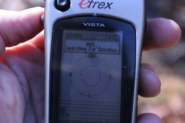
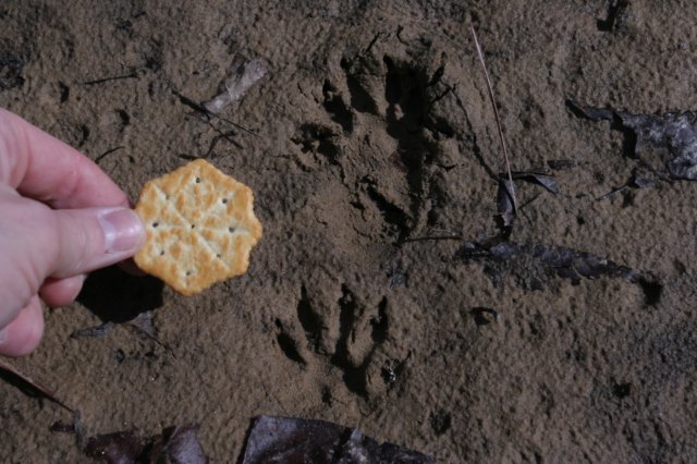
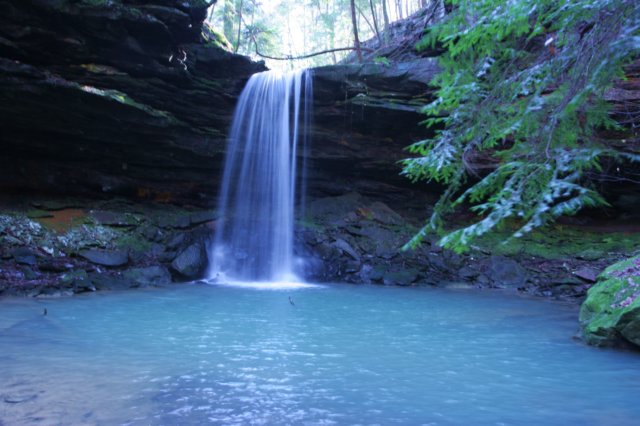
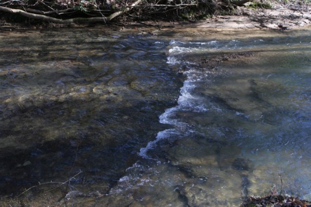
 The gps unit still had not picked up my location, which was very unusual, but so far that had been a non-issue since I knew where I was on the map. I rock hopped back to the left side of the creek so I didn’t have to cross at the junction, and followed bits and pieces of an old road that sported some rock mounds right across from each other at one point. My only guess is a gate once existed there. Due to a beaver dam, the level section of land here became pretty swampy for a bit, but after passing it the stream receded back to it’s normal depth well before reaching the main stretch of Davis Creek. I found an “H” tree here, as I do most places I’ve been in the forest. The walking along the creek again was easy going, even with no old roadbed to follow. I came across a lone boulder split in half which really stood out against an otherwise rock-less landscape for the most part. Soon, another old road came down from the top of the hill here and crossed a shallow part of the stream. Nestled in the side of the built up section of the road were the remnants of an old moonshine still, something I always enjoy finding. I crossed a reasonably deep, but narrow ravine that held no water at all, and I didn’t have the time to explore upstream to see if perchance there was any kind of waterfall at the head of it. I also came across what was probably prescribed burning here, with the bark on some trees burned almost 10ft off the ground. This is not the place I’d want to get caught in a forest fire. This stretch was the longest of the entire trip without turning up some little canyon to explore, and seemed to just go on and on. In the midst of it all, which angrily griping at my gps unit that refused to work, I caught movement and felt like I was being watched. I was indeed! An older couple were sitting on a log not terribly far from where I stood, enjoying lunch and probably as shocked to see me as I was them. It is rare that I run into anyone so far away from the established trails. I made brief small talk and studied the intersection a little to see if there was an easy place for me to cross before heading upstream toward what should be the coupe de grace for the day in terms of waterfalls and scenery. Near the start of the journey up I found some rattlesnake plantain, one of just a few plants out this time of year, and also spotted some raccoon tracks. The canyon here was very wide with a lot of flat bottomland and old roads that crossed the creek several times. I ventured left at the split, and spotted more stone mounds across the creek, though I couldn’t tell what they were there for. The terrain became a steep here, with exposed rock on the high bank and many rocks now beginning to line the creek bed. I stumbled upon an old still bottle that was really cool and in great condition, hidden under a rock. The canyon became narrow here, and the grade was difficult at best on both sides unless one was right along the bluff. I stayed near the creek and tried to photograph some intermittent falls on other side, but it proved difficult to do. The rocky bluff now moved in much closer and the land began to fall away a bit, revealing a bit of a shelter. The air here was cooler too, and I knew I was getting close to the falls. Large boulders were dotted all around, and I spotted a large colony of club moss here! I could hear the falls, and it turned out to be a good 30-40ft waterfall with a wide flow from the top into a very large plunge pool. This is one of my all time favorite waterfalls I’ve seen in Bankhead NF! I was reminded of Sougahoagdee falls a bit, especially the way the canyon wall was very sharp on the left hand side, and there was a second level to walk along for a bit. It did lack huge variety of ferns and plant life that’s part of what makes ‘Soogie’ so memorable, but there is a primitive, untouched feel here that ‘Ol’ Soogie’ can’t match. I climbed up to the bluff here and took some photos of hemlock boughs still encased in ice, though the day had warmed up well above freezing. I found a pretty neat shelter too, with pieces of petrified wood here and there and some evidence the place had been pilfered. A small waterfall was just around the bend, kind of unique too. One section fell from the top of the rock face, and the other seemed to slip from inside the cliff face itself further down. With the terrain getting steeper, I descended a bit to a flatter area away from the bluff, and I’m glad I did. I spooked a rather large pig that had been napping on the bluff just out of sight from where I was. He took off running up through a small section of land that gave access to the top of the ridge. He was certainly much more of a threat to me than I was him.
 Reaching the junction with the other branch of the canyon, I stopped to look an old beech tree that had some carvings on it, but were way too degraded to make out what they were. The terrain here was much more uneven, and I ended up staying on the left side of the stream, avoiding a huge section of dead fall on the other side. Walking here also meant walking along a very narrow game trail that would have been a good 30ft near vertical slide to the shallow water below. Soon I could hear water rushing, and I scurried on a little faster with light beginning to dwindle here in the canyon a bit. It was a steep, slippery descent to the base of this waterfall, a very pretty cascade about 20ft high. The rock remnants of an old moonshine still sat at the base of this falls too. I crossed the stream and climbed the very steep banks of the other side up to the bluff, which gave a great view of the falls and revealed an upper falls area that I had neither the time nor energy to investigate. I followed the bluff on down, passing a nice section of filmy ferns and stumbling across a narrow little stream joining in that I’d missed on the way in being on the other side. I decided to investigate this one, though my knees were becoming sore. This was a pretty nice waterfall, with a good flow coming off of it. It was in the neighborhood of 30-40ft high, with no plunge pool, but my guess is that it flows most of the year comparing it to the other falls I’d seen that day. It wasn’t terribly easy to get a photo of, with a good bit of deadfall on one side, and a sharp bank down to the water where I wouldn’t be able to grab a photo either. On the way back to the main creek, I spotted a nice root-over-rock specimen, with the tree gripping almost like a hand. I also found a fungus that I dubbed the “duck-billed Princess Leia.” Back at the junction, I found a very shallow crossing on some rocks and made quick work getting across Davis Creek, and picked up my pace heading downstream. By this time I knew I’d bitten off a little more than I could chew on this hike, and that I’d have to save the last canyon I wanted to see for another outing. With the gps still not working, my focus was to try and find some way back to the road, and to find the old road bed that the map displayed that would lead me there. At this point, I was following an old road along the creek banks, one that would join the other at the next “big” canyon to the north. The terrain up to the ridge here was incredibly steep, and in hindsight, I should have tried to climb it and get out of there. I took note of some old road spurring off to my right heading uphill at the junction I needed to get to, but skipped it because it didn’t line up with the map properly. Heading upstream on the smaller branch, I tried crossing at various spots to avoid the undergrowth but it didn’t seem to matter as it was very thick even with no foliage. I knew that even if I didn’t find the road as long as I made it to the head of this canyon and could get out, I could get to Cranal Rd. at least. I rounded one ‘switchback’ on an old game trail that suddenly turned into part of an old road for a bit. Below I could see the hemlocks beginning to fill in, but also that the rock faces were beginning to climb. I followed the old road until it dead ended high up on a steep 50ft bank, and stopped to consider things. As I was looking at the map I heard dogs barking on up the canyon and decided enough was enough. Using dead trees and whatever else I could brace myself with, I climbed a small rock face just to get out of there. Wild dogs were the last thing I wanted to deal with. After pushing through the mountain laurel on the canyon edge, I found a bit more inviting open area in the forest, and another fragment of some old road to follow up on and onward. I was beginning to lose light now, and this was the first time I’d ever thought I’d probably have to spend the night out here. I was prepared for it, though the idea of being ‘lost’ in the woods irked me and pushed me onward. I went up to the ridgeline, and to my surprise, had cell phone signal! I quickly fired off some messages to friends, and Jake White, texted me back that he had access to aerial photography and to describe the settings and generally where I thought I was. After pushing though downfall and brush for what seemed like an hour, I finally passed an old watering hole of some kind, and followed a game trail into a stand of young pine trees. The trail disappeared, and wandered downhill a bit just to get out of it, but it allowed me a great perspective to describe surroundings. I gave brief thought into giving up, camping, and the next day hiking down to the canyon and going back out the way I came. But, with Jake’s advice, I kept on walking forward toward a large stand of hardwood trees around the pine forest, finding another game trail frequented and smelled heavily of wild pigs. I began to hear vehicles from time to time, and just started heading toward that sound, finding the road finally as dusk set in. I’m not sure I’ve ever been so excited to see a vehicle. Cold, wet, tired, and hungry, I set out for home.
|