|
|
|
 Tallulah Gorge State Park, GA:
August 20, 2017
North Rim Trail, South Rim Trail, Hurricane Falls Trail
Distance: 5 miles
[View Photo Gallery]
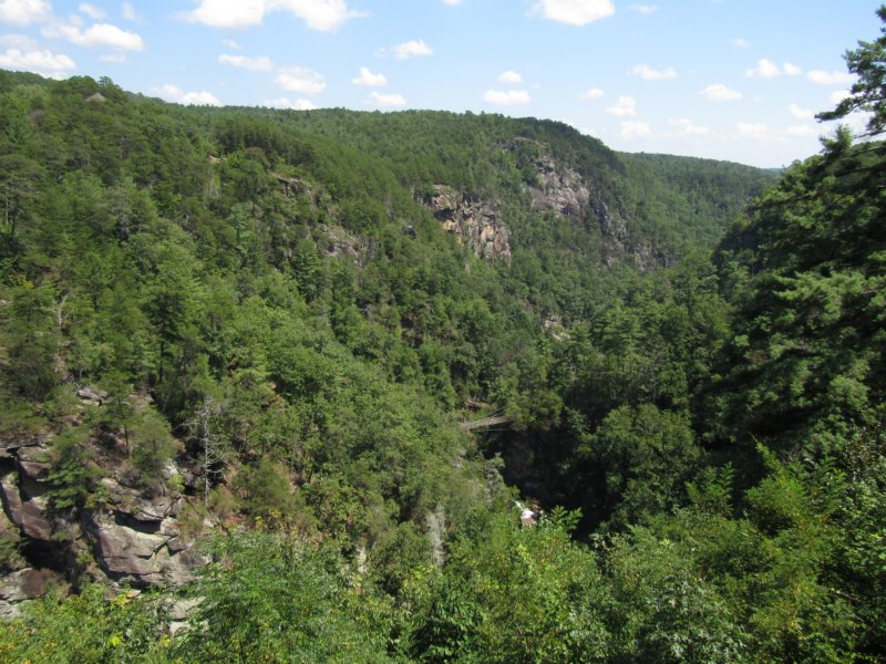
One of the Seven Natural Wonders of Georgia, Tallulah is the deepest gorge east of the Mississippi River, and something that had been on my bucket list for some time. So, when I discovered it was a mere half hour drive from where we were staying for the eclipse, it was a no brainer to take half a day and explore the place. World renown for it's beauty [and to a degree for being the location some of the movie Deliverance was filmed in], it was almost 90 years later in 1992 from the first effort to preserve the land for it to be set aside as a state park. I'll be honest, though, while it is beautiful, it doesn't begin to compare to the scenic vistas of Little River Canyon National Preserve back near home. The waterfalls here, however, are both more numerous and larger, invoking scenes one might find out west. Getting up close and personal with those falls, though, requires some work, as I'd soon find out.
 Before we made it to the state park, however, we stopped at Overlook BBQ, with a view of one of the falls. They called this Talullah Falls, but Talullah Falls is a name that refers to the entire set of six falls that occur along the length of the Tallulah River Gorge between the two dams. An old photograph of Indian Arrow Rapids on one of the information boards looked more like the “falls” visible below, but that wasn't notated on the official trail map, so I'm not exactly sure what we we were looking at. Probably most notable here, other than the bbq, is it's the spot where The Great Wallenda walked a tightrope across the canyon at age 68. We arrived at the visitor's center a little after lunch, and the place was absolutely packed, partially due to the eclipse traffic. The permits to hike the wild floor trail of the canyon were already out, but I suspect they really didn't give any out that day for safety reasons considering the crowd. I was only mildly interested in doing the canyon floor, but what I really wanted was the chance to see as many of the falls and as much of the trail system as I could. After a quick tour through the visitor's center, with a strange multi-level corkscrew walkway that stepped you down through the vertically elongated Jane Hurt Yard Interpretive Center, Robin and I set out on the north rim trail, the path changing from concrete to some kind of recycled rubberized matting that seemed to help with erosion. At the split, we ventured left on gravel for about a quarter mile to the first overlook, with a great view downstream where we could see the remnants of one of the towers The Great Wallenda walked, and also the bbq place we stopped at. There was a limited view of the canyon with everything in leaf, but part of Hurricane Falls, the tallest waterfall in the park at 96ft, or so I thought, and the suspension bridge above it were visible. I didn't necessarily look forward to that climb down, and it seemed I would have to venture it twice to see the north and south rims completely. The slippery slope down to the overlook caused Robin to exacerbate her already hurt knee, and we made it back to the visitor's center where she stayed, and insisted that I go and explore.
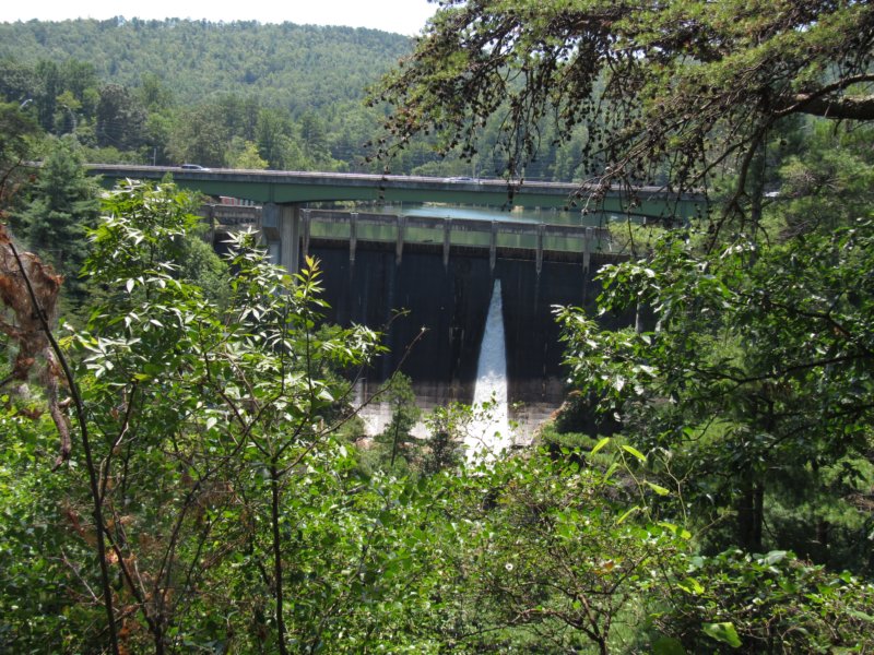 Back on the trail, I made quick work back down to the junction, and headed northwest on the North Rim Trail to overlook #3 [I mistakenly thought the overlook Robin and I saw was overlook 1, but it was 1a, and I inadvertently skipped the first overlook, the sight of the south tower The Great Wallenda crossed on, and possibly great views back upstream.], with a bit of an obscured view of L'Eau d'Or (pronounced LaDore) Falls,a 46ft tall falls, and the giant plunge pool below it known as Hawthorne Pool. The remnants of a 1910 water compressor used in the construction of Tallulah Lake Dam are still visible at the top of the pool, as well as some of the dam itself in the distance. The gorge is unique in the sense that it's dammed on both ends, with Lake Tallulah above it formed by an early 1900's hydroelectric plant originally constructed to help power Atlanta, and Lake Barton downstream [a 2,300m tunnel still transports water downstream to a power generation facility above Lake Barton. It took some grassroots organizations petitioning to have some kind of flow restored through the gorge, which helps protect the Persistent Trillium, an endangered variety of my favorite wildflower. A deal with Georgia Power keeps some water flowing, the so called “aesthetic releases” to show what the area would look like unimpeded on scheduled releases. The trail here split, and I kept right, following a very silty path alongside a narrow stream thick with mountain laurel. If this creek produced a falls it wasn't visible from any of the other overlooks at least, and crossing the bridge, flow was pretty limited at best. The one good view down into the stream revealed a bit of a cave or shelter with a spring flowing from it. Soon the trail made another hard right, with the 10-15ft mountain laurels blanketing both sides of the hill at times. I discovered an old road bed here, the path blocked with a wooden rail and nothing showing on the map above. The next stream crossing was simply drained through a culvert, and a backup of sediment seems to have created a nice spot for ferns to flourish. Large swaths of partridgeberry covered the ground, and I wondered what kind of orchids the area had. As the trail ventured uphill, another road spurred off even steeper uphill, and the sandy trail became more rocky underfoot. Views of Tallulah Dam and the highway became visible a bit, before I stumbled upon the small overlook for the dam itself. Going downhill now, I passed another road that seemed part of some trail system, but it wasn't named on the map. It's probably more likely these are access roads the state park uses for emergency situations. Changing from a dirt path to a long series of descending board platforms, I reached overlook #5, or so I thought. There were actually two overlooks with this number. With it's odd large stone retaining walls and numerous benches, this spot felt more like a relic of some past trail that hasn't had the maintenance it should. Views of the high bluffs below Overlooks 2 and 3 were visible from here, as well as the visitor's center. Passing two more large bridges over dry drainages, I came across the campground connector trail, and the first wildflower I'd seen in a while, leafy elephant's foot. Numerous signs around warned of the danger below the trail, and a dam failure or high release would certainly be life threatening. Here I discovered that instead of backtracking, the trail actually looped up and over the dam along the highway for the single small bit of road walk [a connector trail does extend here down to the Terrora Day Use Area] . Before I did that, though, I wandered down to the 126ft tall dam for a view of 63 acre Tallulah Lake. Crossing the bridge, I stopped to take in the view downstream here of the gorge. It's probably the most unimpeded view of the gorge and Tallulah River, and if you look close enough, you can see some people standing at one of the distant overlooks.
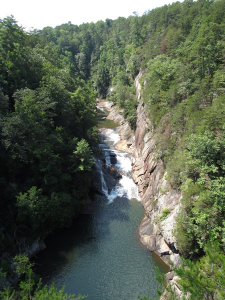
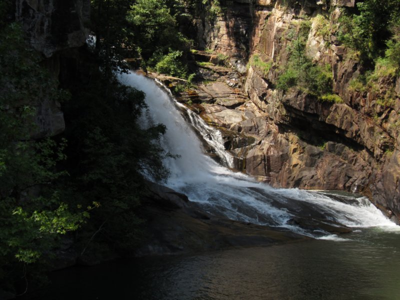 Across the bridge, I noticed some people acting a bit perplexed about the trail system, as the painted directions on the sidewalk indicate you can get to the beach from this side: this is wrong. I'm guessing at one time the dam was open to foot traffic, which is the route indicated, but it wasn't that day. You have to cross the highway bridge here and then go under, taking the connector trail down to the beach and day use area. Changing to a concrete path, the trail meanders through what felt like a roadside park setting. I stopped to read a sign that mentions the Tallulah Gorge Trail System is also known as the Helen Dortch Longstreet Trail System, in honor of Mrs. Dortch, who was one of the state's first conservationists and was part of the early movement to preserve the area. A side trail led to a nice pavilion and shaded picnic area. Situated 350ft above the gorge floor here, it was a great look down at some of the other overlooks on the other side of the canyon, and of Tempesta Falls [76ft], completely obscured by vegetation this time of year. Hurricane Falls and part of the suspension bridge were a a bit visible from here, though, as was Hawthorn Pool. In the distance was the huge 900ft bluff above Oceana Falls at overlook #1, and with a good zoom lens part of the North Wallenda Tower was visible as well. As the concrete path gave way to dirt and gravel again, the trail ventured away from the gorge edge. I'd say “ventured into the forest”, but realistically it felt like you were right below the highway from the noise. At the edge of private land that looks mostly clearcut, the trail was sunk down a bit which helps keep the shade, and provides for interesting art projects to pop up, such as a 40ft concrete mural of the gorge. Ahead, overlook #7 gave an absolutely great view of Tempesta Falls. There wasn't much room here to stand and view though, and with the intermittent crowds, I moved along. The mature wood path here soon gave way to an oddly placed wooden pergola with natural stone columns, one of the many things that seemed much older than the state park given it's young age. Rounding a bend in a power line cut, I finally spotted a few more wildflowers with woodland sunflowers and goldenrod enjoying the extra sun. Unfortunately they had to share space with the ever intrusive kudzu. Also through here was one of the oddest culvert setups I've ever seen, with the narrow channel designed to drain into a storm grate before going under the trail and down the hillside. Passing the Hurricane Falls Trail and rest area with all the stairs, the trail followed a powerline cut for a while, but thankfully instead of kudzu, wild muscadine and fall aster had completely claimed this open area. The trail split again, with the sliding rock trail venturing right past the South Wallenda Tower, and the South Rim Trail continuing on left. I continued on the rim trail, quickly changing again to a nice concrete walkway and what looked like borders for old gardens, though the only thing growing were a few liatris. Taking in fantastic views of the gorge all along this stretch, I stopped at some nice concrete benches with backings built into the hillside for a brief break, some shade, and to check out overlook #8. From here, you could see the visitor's center, as well as the best view yet of Hurricane Falls and the viewing platform in front. The “devil's pulpit” outcropping was right below, though it's best viewed from the lower Hurricane Falls area. The second tallest waterfall in the state [tied with Cochran's Falls] and seemingly overlooked Caledonia Cascades or Cascade Falls, drops 600ft here across the gorge beside the 900ft bluff. It's unfortunately not the easiest thing to spot in summer, but it is briefly mentioned in the trail descriptions on the back of the map, and at overlook #9. The trail continues with a large area cleared out up the hillside. I took one set of steps up a bit, stepping off on a large boulder for an even higher view of the gorge. The multiple sets of steps here seemed to disappear into the trees above, and below, sometimes didn't connect back up with the main trail at all. It's not really clear the purpose of any of these series of steps either Again, it's like an older trail system predating the state park that's fallen into a bit of disrepair. Climbing back down, I stopped for some great shots of Hurricane Falls, large bunches of woodland sunflowers and golden asters providing interesting foreground color as they cascaded off the side of the bluff here. Also from this overlook is Oceana Falls, a good 50ft falls, the top of which is kind of a long, narrow chute or cascades itself. From this view of the falls, it's obvious where the Sliding Rock Trail gets it's name from, though that name is also an alternate name for Bridal Veil Falls, the lowest of the falls in the gorge, and the only one I missed seeing. The south rim trail didn't extend much further, ending at a rock shelter with largely obscured overlook #10. I took a good break on the concrete bench in the shelter, joined for a bit by a silver-spotted skipper butterfly.
 Heading back to the junction with Hurricane Falls Trail, I stopped for more photos of Hurricane Falls, as well as southern harebell, a wildflower I don't run across that often. The summer heat was oppressive where we were camped at Tugaloo, but until now hadn't bothered me at Tallulah. I was happy to get down into the gorge, or so I thought. The stairs you have to climb [the only way to get up and personal with one of the falls outside of a permit], are every bit as strenuous as the climbs at other state parks in the area like Amicalola and Cloudland Canyon. Depending on what sign or brochure you read, it's either 1,122, 1,062, or 1,099 steps down and back out again. The number doesn't matter, it was a lot. I always approach these things downhill too fierce and pay for it on the hike out, and today was no different. The long, arduous walk down the stairs was simply that, long and arduous. The steep hillside here at least had plenty in the way to look at, with scattered hemlocks and large thickets of rhododendron. About midway down, the roar of water brought my eye to a partially obscured view of Tempesta Falls, and come winter, this is probably the best and certainly closest view of the falls one can get. The trail junction at the bottom was a hot mess, with multiple seating areas/platforms all kind of intermingled. I took a few photos upstream of the picturesque canyon before getting tired of the crowds again and continuing the descent to the Hurricane Falls overlook. Along the way, I stopped to check out the state champion hemlock, and was pleased to note that I'd yet to see any of the woolly adelgids that have wreaked so much havoc with these trees. At 58 ft, I'm sure I've seen plenty taller than this back in the Sipsey Wilderness, and certainly much wider than a 33 inch circumference. The views downstream opened up a bit, with the devil's pulpit outcropping very prominent on the right. From this angle, it appears shaped like a head, but nothing much devilish about it. At the bottom of the stairs, my suspicion about no permits being issued was true, the extra crowds forcing them to close the one true wild trail in the park because of safety issues. With my knees a bit shaky it's not something I would have pursued this day at any rate, as it takes some careful foot placement to get across the rocks below Hurricane Falls. I took note that this seemed a kayak put in as well, though the thought of toting a kayak down all those stairs and potentially back again was most certainly not my cup of tea. Nearby on a large boulder was what looked like a waymark, but reads “high water mark /one gate flow”. I can only guess this has something to do with the “aesthetic” releases they do that seems to benefit kayakers. Back to the waterfall, due to the angle of the bluffs, you only get a partial view of Hurricane Falls here, something I wasn't expecting. Those 1100 steps are worth the walk, though, as this area was much less crowded, and I had more of a chance to study the bluffs, the rocks, the plant life, and wander without feeling rushed. Robin was waiting at the visitor's center, and the tick of the clock finally pried me from the spot as we were still intent on seeing Toccoa Falls, time permitting that day. The haul back up the first part of the stairs wasn't so bad, but by the time I reached the suspension bridge trail junction it was break time again. Crossing the bridge some 80ft above water gave great views as expected of Hurricane Falls, though it appeared a bit flat from this angle. The suspension cables made it impossible for clear shots of the gorge, but the view was fantastic none the less. Across the bridge, there's a lower level that's not on the map. I took the one flight of steps down to a nice shaded section against the bluff, photographing some ferns in a seep on the canyon wall, and also of the under structure of the bridge itself. Back on the stairs, the array of graffiti on the railings ranged from the no nonsense “you die here”, to the supportive “almost there” “just keep climbing”, to the inspirational “have courage!”. After multiple stops, and finishing off the last of my Gatorade, I made it back to the ridge and to overlook #2. This is the waterfall and overlook I wish I'd taken Robin to, with a perfect view of L'Eau d'Or Falls, the large Hawthorn Pool, a very scenic and open view of the gorge. The change of the trail here back to the soft rubberized padding was a welcome change from the hard slog of stairs, and eased a pulled muscle a bit from the haul up. The quarter mile back to the visitor's center was uneventful, but I was happy to see the ice cold bottle of water Robin had waiting for me. She shared a number of people watching stories while we explored the different exhibits in the interpretive center. With her leg feeling much better, we set out from Tallulah then in hopes of reaching Toccoa Falls before the day's end.
|
|
|
|