|
 Mountain Longleaf National Wildlife Refuge, AL:
November 25, 2016
Smokey Mountain Loop Interpretive Trail, Longleaf Trail, Ridge Road Interpretive Trail
Distance: 7 miles
[View Photo Gallery]
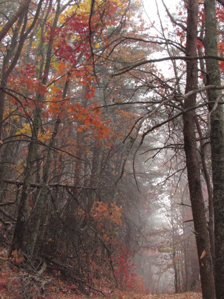
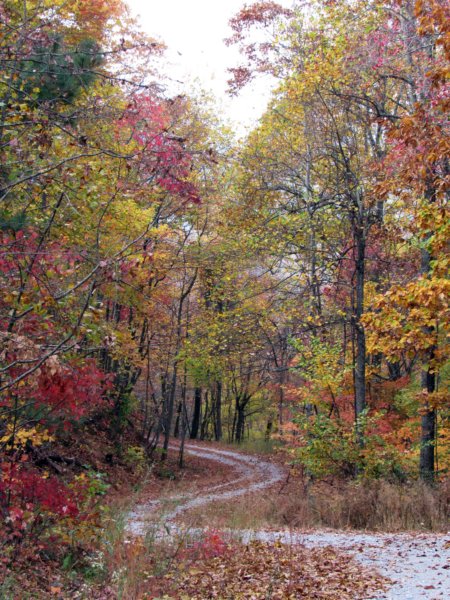
Dedicated while I was still a student at Jacksonville State University, I finally got around to seeing this place. Half of it is off limits because of unexploded ordinance, and the area open makes use of old roads as trails. I hiked 7 miles, saw the Smokey Mountain Loop and Ridge Road Interpretive Trails, as well as another trail known as the Longleaf Trail. The fall colors were wild at times and the thick fog added some ambiance and helped one trail really live up to it's name. At roughly 2000ft in elevation, Choccolocco Mountain is one of the tallest mountains around, shy of Cheaha, but offering it's own great views.
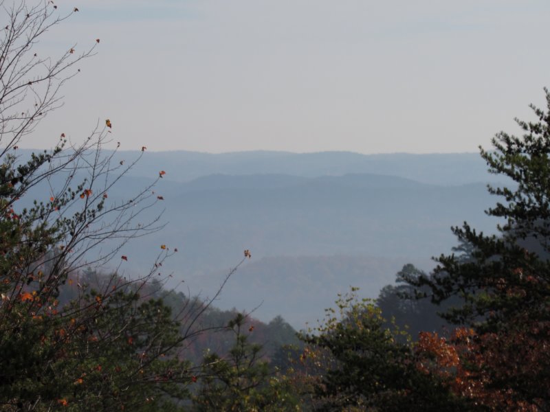
I stopped at the first kiosk I saw, a place listed on the map as off limits, yet there were no “closed behind this point” signs around. A large poster on one side showed various types of unexploded ordinance one might find, so despite potentially being open for exploring, I continued on to the intersection of Bain's Gap and Military Road. It was disappointing to find no brochures at the main kiosk here either, and I was now more or less searching for these “trails” by memory. The view of the distant mountains was nice, ridge after ridge fading into the haze of distant wildfires. After reading the history of the refuge, and notating that there is indeed hunting allowed [and I had no hunter's orange with me], I set out for TR 317, the so called “smokey mountain trail”. Military road was quite bumpy, though the rough ride was offset a bit by the fall colors and thick fog blowing through at times. Passing other so called trails I noticed the numbering system did not match the numbers from the online map. To my surprise I spotted a kiosk in one parking area with a sign announcing the Smokey Mountain Interpretive Trail. In what research I'd done, I'd found nothing about an interpretive trail or even an officially named trail at the refuge. Though no brochure I could take, I was at least able to take a photo of the map to kind of guide me. The informational side of it talked of how the western flank of the mountain was used as target practice by the military for a long time, leaving the eastern flank mostly clear, and thus, open for recreation.
 Passing the gate on the trail, and a sign depicting the old road bed as “20B”, I stopped to admire the colors and the fog moving through the valley, doing the trail name a bit of justice. Easy and flat, the trail meandered back and forth, passing an old pond of some sort before joining another old roadbed, listed as TR 315. Off to the side old metal barrels lay rusting among the giant piles of rocks, leftovers from the arsenal days. Ahead, the canopy gave way briefly to young pines and tall grass, obscuring another side trail that would later turn out to be the return portion of the loop. I spotted more old barrels off in the woods, but I'd no interest in venturing off trail given the history of this place. Along the old roadbed's edge rocks lined the way, and a large circle of rocks, too large and oddly placed for a fire ring, sat trail-side. Though thick with leaves, there was a bit of a depression in the center. This was also no place for a moonshine still nor did it make any sense for one to have been there. Another relic of from the land's military days? I'll probably never know. Past here mountain laurel the size of small trees blanketed the woods, and the effects of this drought on them were quite evident, as many were dying or dead. The morning fog continued to wisp across as the path straightened for a while, the tall mature stands switching oaks and hickory for pines and then back again. I scanned the drainage to my right for any sign of water, though I'm not sure a waterfall could have even tempted me off trail. I rounded the hill the fog broke, the sun using that small sheen of water to add some additional magic to the colors. As I crested a bit of a ridge ahead the trail seemed to split again, though the route left led nowhere. I did stop to photograph some of the small rock outcroppings here, my interest piqued after a friend shared an article describing the Native American's use of rocks around here to create sculptures of sorts. The trail pulled away from the edge and led downhill slightly, with more interesting little rock piles and one obvious campsite, though it's been some time since it's seen any use. Around another bend TR 319 spurred off just past two rock cairns, descending to probably the best shot around here of seeing a waterfall, albeit dry, but I continued on downhill. A few goldenrod holding on provided the first wildflowers I'd seen, just past another old road bed. The trail meandered through a saddle and up the next hill, greeted by two hickory trees with arms extended wide. I spotted an interesting rock formation, and for the second, and last time, I ventured off trail to check it out. The rocks seemed to radiate out from one point, but it could also have just been my mind wanting to find something. The distinctive crunch of a large pine cone sent my gaze upward to the tallest longleaf pine I've had the pleasure of laying eyes on. Crossing the far upper portions of a drainage the view downstream looked like a painting, and a good one at that. The lower I dropped in elevation the more the colors seemed to pop, and drop I did, almost 600ft in elevation change over the next half mile or so. On the shaded side the trail the steepness allowed for some nice long stretches of mosses of many colors to thrive, including some fantastic little colonies on some of the large rocks around. The trail finally leveled out, and I spotted water in a narrow little channel. Uphill and around the bend a little, an old fence probably marking the extent of the refuge or military land was topped with rusted barbed wire. Here I also found two little channels feeding a small but full pool, but no evidence of anything flowing. I stopped for a break on what was the only bench on the trail, and to check out more of the longleaf pine cones before the yellow jackets stopped to check me out, sending me on my way. The road split, with the trail route decisively more uphill than the other route. Unrelenting, this section was twice as long and never really featured any good spots to stop and catch your breath. If I ever do this trail again, I'll hike it opposite of the way I came. The climb did offer a few pleasures in the form of occasional views toward the town of Choccolocco and the hills and mountains of the national forest east of there. I also found some of the tallest lobelia I've ever seen, a good 5ft high, with just a few blue tinged white blooms hanging around. Large clumps of an aster with narrow leaves past bloom and a few mountain mint marked the trail as well as it continued uphill. Once it finally did start to level off, the mountain laurel returned as well, in slightly better health than their counterparts on the other side of the hill. A trail sign noting this old road as “20A” hung with it's letters peeling off. I recognized the brushy grassy area ahead as the spot I'd bypassed when I started thinking it was an overgrown old road, but it merely masks the otherwise weed free route due to the steepness.
 Retracing my steps to the car, I decided to explore Military Rd to see if there were other interpretive trails, and if not, if I could figure out which of the old roads led to the so called “longleaf trail” I'd seen in research online. Along the road there are some dead serious, but hilariously designed [to me] warning signs regarding the closed section. The “Danger Impact Area Keep Out” signs with the cartoonish exploding hikers gave me quite a laugh. After finding the road deadends with no other official spots to hike, I counted back and figured out which trail lead to the “longleaf trail”, and set out down it. My knees were a bit whipped from the uphill slog earlier, but I wanted a little more than 3 miles of hiking, and also the chance to see more of the namesake pines. The trail quickly went downhill and split. I hung right, down a more narrow path than the Smokey Mountain Loop, crossing a dry drainage before slipping on a ton of hickory nuts. I left them for the critters. It wasn't long before the pompom youngling longleaf pines cropped up, though many here were dead or dying. Even the large older pines seemed to be suffering pretty harshly in this drought. A large snapped pine left enough height to walk under, though it was dangling a little precariously from it's stump. Up until now the short trail was straight, but rounded a bend where a large circular area looked disturbed, with a giant pile of soil in the center. Nearby a large flat rock looked placed as a sitting area, or perhaps for a small campsite with the tall flat stones opposite as heat reflectors. It was around here that I also saw the first evidence of wild pigs. Fresh scat and shallow dug areas pockmarked the trail. Over a small little hill many more little longleaf pines had sprung, all along a section covered ins mosses and lichens. The area was so rich with mosses that the trail itself was completely green in places. It was near here views of Silver Ridge of Chocolocco Mountain opened up, a trail on my short list to see here, but it's distance was a bit of a time burden due to it's out and back nature, or a road walk. I found another, different kind of goldenrod before reaching the end of the trail.
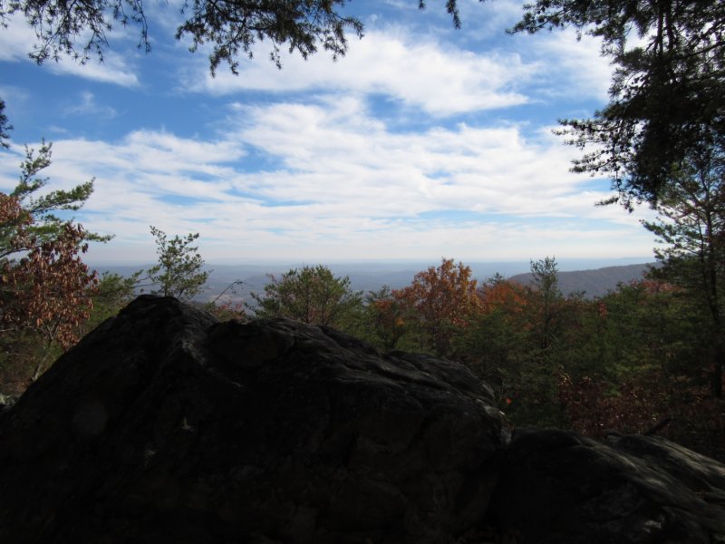
 Heading back to find the overlook on the other side of the mountain, I passed an old concrete structure obviously military related, and saw something else that caused me to slam on my brakes. Resting on the back of a tree close to the road was a small black bear; a small, stuffed, black bear. Back at the road junction, the view northwest showed nothing but mountain after mountain, and far in the distance, wildfire smoke. I spotted another kiosk, listed as the Morton Mountain Interpretive Trail, but it was closed to entry. Following Military Rd. on the other side of Bain's Gap, my vehicle almost didn't make it past one spot on the road due to the steepness and poor road conditions. The parking area for the Moorman Mountain Overlook wasn't more than 100ft from the overlook itself, offering the best all around views to the east across the Talladega Mountains and south over the many fingers of Choccolocco Mtn. A bit of a misnomer, Moorman Mountain is actuall a hill, not a mountain, according to USGS Topo maps. The overlook itself was fairly well trashed, with a lot of spray paint and litter strewn about. It also appeared that the trees in front of this rock outcropping had been purposely cleared to provide this overlook, something else I'm not keen on. Out of curiosity, I followed this road to it's end of this side of the mountain, discovering the Ridge Road Interpretive Trail. Though a little short on time, I saw this as a way of completing the available trails, so I set out down this old road bed to see where it led. On the hill to the left apparently once sat a transmission tower at the top of Moorman Hill. The old road more or less followed the spine of the mountain, with rock outcroppings that offered more limited views east as the overlook did, and thick forest to the west limiting sight of anything. The whole route had the feel of walking a country road, though you'd never have to worry about a vehicle here. As the trail descended a piece, I spotted coyote scat, and took note of the landslides that have been occurring. After a long jog downhill the land leveled out again for what seemed a lot longer with my tired knees. The end of the trail, which clocked in around 1.5 miles one way, was marked with an orange cone and a tiny “end of trail” sign. The land beyond this was still technically close to the public, though no signs around notated as such. As I exited the trail, the late day golden hour was setting in, and I took a number of photos of the light playing with leaf colors, as this would be my last outing on a trail with the leaves up. A heart full of adventure and a bucket list place checked, I headed home.
|