|
 Bankhead National Forest, AL:
November 20, 2016
Capsey Creek, Kemp Branch
Distance: 5 miles
[View Photo Gallery]
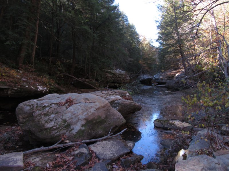
Sort of picking up where I left off last winter exploring, my friend Ryan and I decided to explore farther upstream on the north side of the creek, searching for waterfalls and the elusive sun disk carved into a rock along the banks of Capsey Creek. With the current drought situation bringing water levels down to those not seen in a long time, we were able to see more with less time, including several signifcant streams flowing into Capsey, and Kemp Branch.
We parked a piece up from the bridge over Capsey, dropping down into the canyon at a waypoint I had that led down through a gap in the bluff. A large beech tree stood nearby, but I found no carvings. Immediately into a long low shelter, we found a nice colongy of filmy ferns against the back wall, but nothing more. A good 30ft falls lay just past, though dry. At the shelter behind the falls though was a spring unfortunately being used as a pig wallow. The destruction these beasts wreak on the landscape here continues to worsen. Above the falls we walked out on a bit of a ledge, really kind of a middle narrow middle tier, which always provides a great view and wouldn't have been a half bad spot for a lunch, had it not been so early in the day. The colors through the canyon here were at the peak of their powers, the reds, golds, and yellows flashing with as much flare as the ridges I saw on the drive in. A second falls soon came into view, with a much larger shelter, with a tall rock cairn built toward the back. Like the previous one, this one was dry as well, and another spring provided water for the small plunge pool below. Turning downstream, we kind of fumbled our way over the slippery rocks as the banks were too steep and high to get out of for a bit. An old road bed ahead provided some relief, and we broke away cross country toward something called the �eyes�. I was looking for and expecting a tree carving, but decided to indulge the gps unit and venture uphill toward the large rock outcropping, fighting my way through the mountain laurels to get to it. Instead of a carving, I found two small windows of sorts through the rock face, much like the eye of the needle in Sipsey, though barely enough for me to squeeze through without a pack on. The far side had a much better sitting area, though nowhere to pitch a tent. This was certainly one of the most interesting formations I'd seen in Bankhead, but what lay around the next bend was even more enticing. I called out to Ryan, who was exploring below along the canyon wall, and we had a brief snack before continuing on around the bend to see a 50-60ft dry falls, with the plunge pool area still muddy and carved out almost bowl like. I ventured down inside the poo area, discovering a number of ferns and liverworts beneath the the lowest of the tiers, while Ryan explored the upper reaches. After the climb out, we stopped to explore several little holes in the bluffs, which led back much farther than we or the light of our flashlights could.
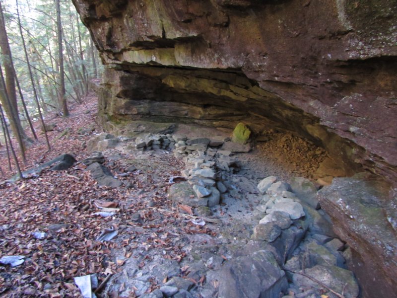
 A large fallen tree sort of pointed the way to the next area of interest, a spot known as �honeycomb hideout�. Climbing up, we had to duck our way into what became the first of two rooms we'd find. An excellent camping spot, I spotted a small fire ring on the outside of the the initial wall with a great place to sit and look out down the canyon. Almost on hands and knees, we squirmed into the next room, which opened into a 8-10ft tall ceiling, leading back probably 20ft or more. With room easily for several tents, this spot could hold quite a number of folks if needed, and the fact that we found no trash made the place even more special to me. I searched every crack and crevice I could find in the roof for bats, but nothing turned up. Downhill from the shelter, I spotted the first very fresh hog sign of the day. By the small creek we found the remnants of two old stills, though little more than the stacked rocks around their bases remained. Finally reaching the main channel of the side branch of Capsey, we decided to venture upstream and explore the next branch with the terrain being easier than anticipated. This unnamed side branch had a surprising amount of water in it, and were it not for private property, I could have been inclined to follow it to it's head to check for waterfalls. I crossed the creek on a weak tree purposely as a bit of a joke and it of course gave way about midway through, landing me perfectly on a little gravel bar. The initial look at the side branch seemed promising with a small cascades flowing down into a nice pool. The canopy overhead, as it'd been for a lot of the hike was mostly hemlock trees. Small bluffs began to appear and then quickly came to a head, though we couldn't see the actual head of the canyon for the number of large boulders that had filled the stream just below. A very slick scramble up the side of the bank, which sloped from the bluff all the way to the water revealed an interesting seep, and a still site! This is by far the most unusual placement for a still site I've ever seen, and I suppose at one point the spring feeding this was much more pronounced than it was today. Reaching the falls, we found it a trickle, and I explored a small bit of shelter about midway up the 15ft face, finding nothing of any interest. Just before our ascent, though, Ryan had spotted an interesting looking side falls with a bit of a cavernous shelter, though riddled with pig wallows and thick mud. A cool sloped rock allowed for an interesting entrance beneath the falls, with several springs seeming to flow from various spots in the shelter. Not far away, we spotted what looked a lot like the snake carvings found on Gillespie Creek in Indian Tomb Hollow. Though faint, a pretty definitive head could be made out. Back downstream, we came across old property markers, though this didn't match up with the map at all.
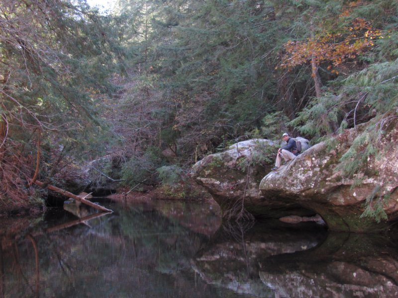
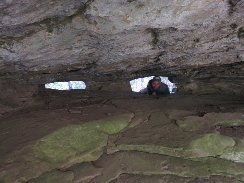
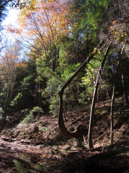
 Staying high on the slope to avoid some of the steepness, we stopped to photograph an interesting tree that appeared to be doing the split along a long square rock, one long root riding the the top of the rock for the entire length. The fall scenes downstream from this height were spectacular. As we made our way to the stream's edge, I stopped to photograph the varying water scenes, from shadowed ripples in the sunlight, to pools as still as glass giving off a painting look with the dark waters and vibrant fall colors. Moving downstream, we stopped to take in some of these views, the wide creek framed by the mature hemlocks, and at times, towering beech trees. Briefly pilfering through rocks, I came across an Odin stone, something I've not seen in a while. This one, however, was the size of a large sand dollar. We picked up an old road bed soon, and Ryan decided it was his turn to cross on a tree, though I decided to cross on rocks instead. I'd already taken a few falls and didn't want to add a dunk in the creek to the list. The road bed ran along that side of the creek for a long while before petering out at a taller bluff. Briefly, the creek seemed to narrow, and the banks with rock outcroppings became more numerous until the junction with Capsey came into view. True to form as I remembered it from my previous hike, the bluffs here were high above the creek, but with the water being so lot it quickly provided us a way to get down stream level and walk away from the thick mountain laurels. The water was so low this day, that we crossed soon on a sandbar, standing on dry land in the middle of the creek itself. From the tracks we found, many deer were using this same route as well. Heading upstream, I rock hopped through what had become rocky shoals, stopping to photograph large almost stagnant pool just ahead. A number of large ferns along the way that are usually waist high were dead. We explored an enchanting little hemlock grove on the south side, following another old road bed for a bit. Like every creek in Bankhead, it is a constant back and forth effort to avoid the worst of the terrain. Just as we found another long stretch of dry land in the stream to walk across, I spotted large boulders along the banks up ahead. The sandbars disappeared as the creek returned to a more normal form, forcing us to pick sides. Ryan went on ahead and I shot a few photos of him out on one of the boulders for size reference. It is truly amazing to see rocks of this magnitude in Alabama to me, and hard to explain to people who've never seen them just how large they really are. Through here I found the first wildflower of the hike, an aster of some sort that had already gone to seed. Now split up, Ryan and I attempted to keep sight of each other on opposite sides of the creek, though he made much more forward progress than I, as I stopped at a patch of iris and a lot of interesting rock formations. I stopped a lot, really. I found scat on this side of the creek, and Ryan spotted a large dead turkey vulture on the other side I'd later learn. As we neared the next set of boulders, I checked my gps unit to see where the infamous sundial was located. It oddly wanted me to go uphill, which I did for some reason, climbing through some terrible storm damage almost to the bluff line before realizing I'd clicked beside the waypoint, throwing the location off. After remedying that, I ventured back down creekside after shouts from Ryan to figure out where I was. We searched every boulder we could put our hands on within a 50 yard radius of the point, and still came up empty. After half an hour of searching, we had to push on. I'd heard that the petroglyph was degraded quite a bit, and with as many leaves down as there were, it's possible it was buried right in front of us and we never knew it. Staying to the south side of the creek where we could walk creek level, we explored some of the tall 30ft bluffs on the other side, including one decent sized creekside shelter. Through here we saw more tracks, this time raccoon, and I spotted another wildflower, the very common cranefly orchid. I also noticed a waterfall that was just barely flowing, but flowing none the less. After seeing bobcat tracks for the first time in a while, we ran out of land and crossed on a log jam. The far bluff featured a long retaining wall for camp someone built, as well was a wind block and multiple spots to house a campfire. It's by far the most elaborate stone structure setup I've seen in a bluff shelter before. Around the bend in the next shelter, we found another one, this time with a large stone chair built almost like a throne. We figured they must have been pretty recently constructed, as neither of the fire rings had been used at all. On a beech tree just past here, we found a little alien man, or a humanoid rabbit with long ears and long arms as if reaching for something. What appeared to be a year carved below was so faded it was illegible. From here, we decided to push on to the junction with Kemp Branch at least, and then turn back. As I stopped to photograph some distant rocks in the creek, something reflective flashed my way, like a scope or binoculars or something. When Ryan caught up with me we discussed and investigated the spot, but found no one nor any evidence anyone had been there, which was a bit odd. We passed the first bend where a smaller stream fed in pretty quickly, something we'd explore later. As we continued upstream on Capsey, the landscape changed a great deal: the tall bluffs were replaced with more gentle slopes for now, and the banks weren't as steep to the creek, but there were longer stretches of pools. As we crossed back to the south side again, the hillside became incredibly steep, however, and combined with dry soil, and heavy leaves, the acorns mixed in acted as marbles, constantly causing me to fall, as I lacked the aid of my hiking staff. We passed a cascades of sorts, with a pool of water that I'm happy neither of slid down into before seeing the terrain level out again.
 To my surprise, when we reached Kemp Branch, Ryan ventured up it. I wasn't going to willingly shorten the hike so I followed along, unfortunately having my camera battery die in the process. This was one of the few adventures where I had to rely on my cell phone for photos to finish out the hike, and in the lower light, it performed pretty poorly. Having my camera battery die had become a recurring problem, unfortunately. The loss of my backup battery has really started to affect my hikes a bit. The walk up Kemp Branch however was extremely easy, but had the feel more of the very upper reaches of a creek system versus something with any expected elevation change at the end. We didn't get terribly far up Kemp before abandoning the effort in the essence of time, as it was a long walk back to the road at this point. We found an old road bed on the west side of the creek to help us out a bit, before veering off sort of back the way we came, though we kept strictly to the south side of Capsey Creek, fighting loose sand as we descended past tall bluffs above the water. When we reached the first bend we'd passed, I mentioned something about hiking that route instead of going back the way we came to shave time getting back to the road. Ryan agreed, and up that side route we went, past some remarkably tall bluffs we hadn't seen when we passed it initially. It took a little bit of studying and initial disagreeing with where we were on the map to figure out more exactly where we were, and decided on a gamble to go up an extremely dry drain in hopes there was an old road that crossed it at some point. It did, and thus confirmed where we were. We fought though bramble and briar, extremely thick underbrush for a long while before I spotted very tall pine trees way up on a ridge that I knew had to be the road, I just couldn't discern the best route to get there. Ryan took point, as he could hear the vehicles passing. With the compass pointing us into even more thick brush, we veered off through a young pine forest before finally making the steep climb uphill to the road. Happy to see it, but still a long walk ahead, we compared notes and chatted about possible future plans to explore Capsey south from this same bridge sometime, before parting ways home.
|