|
 Red Mountain Park, AL:
September 17, 2016
Eureka Mines Trail, #13 Mine Trail, Ike Maston Trail, #14 Mine Trail, #14 Mine Connector, Ishkooda trail, Ridge Walk Trail, Redding Trail, Songo Trail, BMRR South Trail, L&N Trail
Distance: 6 miles
[View Photo Gallery]
Dropping my brother off at the airport, I found myself in Birmingham on a warm day with an afternoon to play with, if with a threat of rain. I'd long been thinking of seeing what I consider Ruffner Mountain Nature Preserve's “sister” hiking destination, Red Mountain, as both share a rich history with mining operations. I'd read about neat treehouses, great vistas, and of course, a peek back into history with numerous mines and other relics of days gone by. After a little searching I found the most popular trailhead, the south trailhead, and set out to see what I could.
After an initial stop at the welcome center, where we inadvertantly showed up in the middle of a half marathon event, and ran into Pete Conroy from Jacksonville State University in the process, we ventured over to the falls, away from the crowds for the most part, enjoying early reds and yellows mottled the riverside and surrounding hills. The waters were noticeably silty from the recent rains, and definitely higher than normal volume for this time of year. Despite the cloud cover, neither Randall or myself could get our cameras to work properly in the cloudy conditions to achieve the milky look of the falls we were after. Robin took some nice shots of one of the smaller cascades upstream I'd been ignoring. In terms of scale, this is by far the grandest place I've ever taken her; it's a far cry from some of the waterfalls and vistas of Birmingham. Little River Canyon is a far cry from anything else in this state for that matter. Nowhere else is comparable with regards to canyons, and perhaps only Mount Cheaha rivals the vistas in terms of scenic quality. As we were walking back toward the parking area, Randall asked about trail options. I mentioned the two popular steep ones, but also a newer trail that I'd yet to see that we were walking right past. I cautioned I knew nothing of the terrain, and the fold up maps had yet to be updated to include the Martha's Falls Trail. I could remember chatting with someone my last visit when I visited with mom who approximated it at about three quarters of a mile one way. In reality, it would end up just a hair under a mile, and excluding the trail at the Mouth Park, is the easiest trail in the preserve. The last leg of the hike, though, would prove to be a bit problematic.
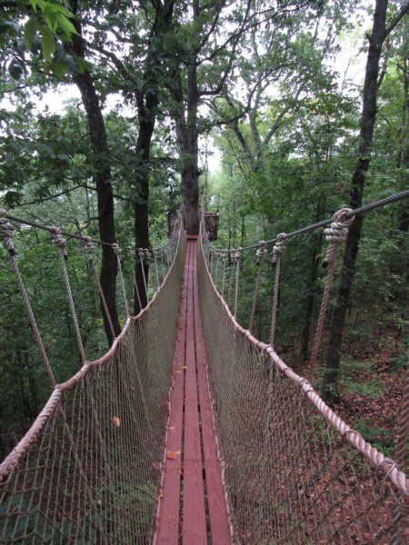 A short connector trail led on to one of the main through routes of the park, the Ishkooda Trail, and certainly one of the more heavily used trails. It was kind of back to hiking on an old road bed, which is what this was. The rain seemed to pick up a little and then retreat, but the radar showed the bulk of the activity yet to come. Winding past some rock bluffs, the trail scooted downhill a bit before crossing a service road to a tower on top of the mountain before diving deep into the thick woods again. As the trail broke into a clearing, I found another rock outcropping, thick with oakleaf hydrangeas and american beautyberry, hiding a date of “Dec 01 1922” etched into its side of the bluff. Following the narrow ridge, the views down into the valley on the south side through the forest were nice, so thick that you didn't get the feeling of hiking in a large populated area. A spur to the left soon led to Rushing Rendezvous, the first of several “treehouses” located in the park. These are not so much treehouses as they are bridges out to a viewing platform attached to a tree. The cabled bridge offered a bit of a swinging bridge feel, and is probably my favorite area in this park. Despite the sign, I bounced gleefully like a kid from one end to the other, laughing the entire way. The views to the north of the rolling hills and mountains of Jefferson county were nice, though not comparable to the King's Chair of Oak Mountain, or the overlook from the large quarry at Ruffner Mtn. Just a short walk past were stairs leading up to the main overlook, Grace's Gap. The spot left something to be desired, though, not much more than a powerline cut. Were it not for the zoom on my camera, the views I captured of the downtown Birmingham skyline would not have been possible. Nearby I spotted a fence lizard scurrying among the rocks, and took some photos of resurrection fern and mosses, perhaps the only things not stained red in this park. I followed this old trail spur, which dead ended where the boardwalk is now and crested a hill before joining back with the main road/trail. A quick stop at the Rushing Rendezvous site again, and I was on my way.
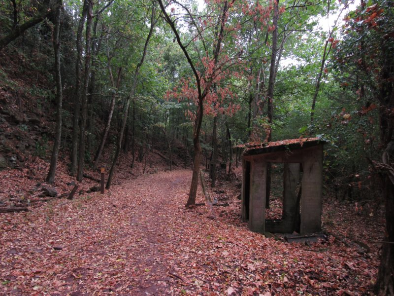
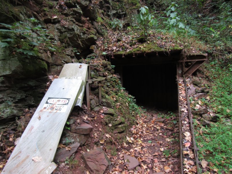
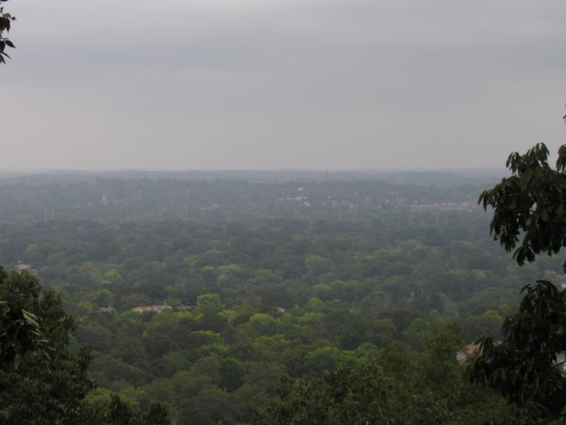 With the rushing wind and increasing rain showers, I was sure I the storms were arriving and I'd be drenched, so I stopped for a moment under some thick canopy and checked the radar again. Much to my surprise and delight, the storms had collapsed, leaving me now with the option of hiking for several more hours, and possibly seeing almost all of Red Mountain in this single trip. Encouraged, I skipped the downhill trip and continued on the Ishkooda, passing piles of rusted metal that were obviously mining related, but in such a state you'd never know their original use. The large rock outcroppings appeared again, with another tiny cave or mine entrance, and a spur leading to the #14 Mine Bath House and Riley's Roost, another in the series of “treehouses”. As I turned down the trail, I was greeted in the distance by a strange bunker looking feature, what must have been the foundation for the old bath house. The entire floor of it was metal, and numerous vents all along gave it a very creepy appearance. Snapping some photos beneath it, the mineral rich soil was seeping through the corrugated steel plating, causing numerous white stalactites and stalagmites to form. As I continued snapping photos, a very loud growling noise echoed. As I only had the flash of the camera to illuminate the area, I decided not to push my luck and left to see the next tree house. Riley's Roost not really a treehouse, but effectively a boardwalk out to a similar viewing platform as the first, with a bird's eye view of the #14 mine. The change in elevation looked much steeper, though the drop wasn't that bad. Returning to the bathouse, I found another adjacent structure of some kind with old ceramic pipes. I'm unsure what this was used for either. I did satisfy a curiosity of walking around on top of the creepy bathhouse bunker, finding what looked like old steps on the backside. Back on the main trail, there were many additional structures, including a shack like building except the center was dug deep out of it as the old road paralleled the bluff. Glimpses of the old road bed itself peeked from beneath sediment that's built up over the years. The shapes of some of the structures leads me to believe they held storage tanks of some sort, but this will be something I'll have to research more. Stopping at a neat bench built completely of rebar, I watched a group of robins enjoying the woods after the rain ended.
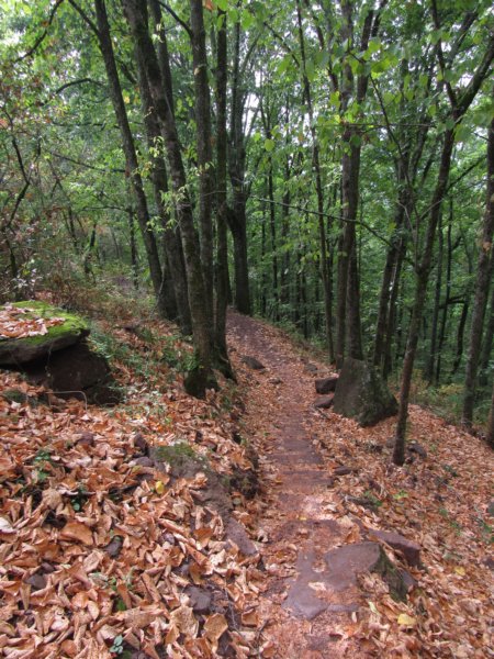 Finding more ruins, which looked to be a sort of old rain line of sorts, and downhill I spied the #13 mine. The aerial photo on the kiosk map didn't really show any of this but the setup undoubtedly changed over the years. I would wager that they probably hauled the ore uphill and loaded it here. A kiosk at the Protective Life Picnic Area just ahead described these old set of ruins as a former shop according the to the map. I found it a kind of neat concept that they used the old foundation here to house the picnic tables, and wandering through a separate hallway of sorts led to an outdoor classroom with a really large cool firepit. A second building foundation with rail line still visible sat adjacent to the classroom. I chatted with a lady and her daughter, also first timers, and pointed them in the direction of the treehouse with the cool bridge, before taking the ridge walk trail at the split. A cool find for me, and a first, I stumbled across some bird's nest fungus on a log. The seeds look a bit like eggs, and they're designed to fly out when rain hits the inside of the 'nest'. This would be the first of several flora I'd spot on this trail, something the park had been a bit lacking in until this point. The path, and old road or rail line, stood a good 20ft above the surrounding forest on either side, which made for a great vantage point of the rock outcroppings that paralleled it. One of the many butterflies I'd seen flitting around, a red-spotted purple, finally settled long enough for me to snap a few photos. An unfortunate break, though, to the seemingly wild nature of this particular spot, were the cars zooming by on some road just visible through thick understory. A large telephone pole, aged to the point where it almost looked natural until one noticed the upper part, stood among the others that have reclaimed this land. For another half mile or so the trail continued on like this until meeting up with the Redding trail. At another junction, I ventured uphill on a section that served as both the Redding trail and the Smythe Trail. I stopped at a cave here with a wooden fence cordoning it off, though the stench from the air coming out of it was plenty to keep me from wanting to take a peek inside at any rate. According to the sign, the cave/mine was privately owned and still active. The trail again became a wide road as it led uphill to the Ishkooda Overlook spur. Located in a petroleum pipeline cut, the view north includes likely the facility the pipeline feeds, but is otherwise a more picturesque overlook than Grace's Gap. Back on the main trail, I stopped for a look at a gulf frittilary and pear crescent butterfly messing around with what looked like coyote scat. Continuing, the trail was a bit uneventful, except for one random chained old road with a sign that read “Please stay on the path”, which I did. I found a sign for another treehouse on a spur trail, the Skyhy Treehouse or Haskell Hideaway as it's mentioned on the map. By not taking the trail that led forward from the Ishkooda overlook I ended up missing mine #11, and I'd end missing several others [#15, #10], which may be something for a return trip. This treehouse was equally as cool as Rushing Rendezvous, and for me, had the best overlook as well. Not only were the mountains in great view, but the tall skyline of downtown Birmingham was also there, but easy enough to avoid or ignore if you wanted too. I took some time and studied the construction of the treehouse itself, something I've always had an interest in building one day. The bolts used to anchor the platform and the swinging bridge were quite large. Without the time to explore onward to the #10 mine, I decided to cut downhill on the Songo Trail, where finally the path became more like a true trail. Crossing several bridges over dry streams, the canopy broke quickly as the Redding Hoist House came into view. The structure is in pretty poor condition, though preservation efforts appear to be in work to stabilize it. The BMRR Loop Trail, named for the Birmingham Mineral Railroad passed nearby, which ended up the way I'd loop out. Another wide road of a trail, the land to the right once comprised some of the miner's housing. All that stands now, though, is thick kudzu, and in blazes ragweed close to 10ft high. The sweet smell of kudzu blossoms tempted me close to the ragweed entanglement, despite what the plant does for my allergies. A few straggling coneflowers remained here in bloom, despite the drought. Another thing noticeable about this section were the numerous bat boxes around. Given the local landscape's propensity for caves and the one's I'd seen on the day's adventure, it wasn't a shocker. The rest of the trail was a nice easy walk through a forest, though, and with the exception of a few brief stops to explore small spurs that led to hidden rest areas and more outdoor classrooms, it was all fairly nondescript. I made my way back the way I came, though this time taking the L&N trail back to the Eureka Mines trail instead, stopping to chat a little longer at the information station, before making my way home.
|