|
 Bridgestone/Firestone Centennial Wilderness WMA, TN:
September 4-5, 2016
Polly Branch Falls Trail, Caney Fork River Trail, Jenny Branch Falls Trail, Chestnut Mountain Ranch Trail, Welch Point Day Use Area
Distance: 10 miles
[View Photo Gallery]
Ever since I hiked the Virgin Falls Pocket Wilderness in 2009, I'd wondered about the trails on the other side of the road. Those trails are part of the 10,000 acre donation from Bridgestone, Inc., treated as a wilderness area, mostly, and designated for use as a Wildlife Management Area by the State of Tennessee. The area now consists of 26 or so miles of trail and eventually will link up with the trails from the Virgin Falls area, including the relatively new Welch Point Day Use Area, a fantastic vista over Caney Gulf and the Caney Fork River. Needing a bit of peace and quiet, I decided to finally explore some of the trails and check out some of the waterfalls, which, despite the continuing drought, I held out some hope of seeing in flow. This would also be my first true solo camping trip in a while, and the first in bear country, a fact that almost caused me to abandon the trek altogether.
Finding the local trading post that sold maps closed, I went on to the parking area, which really had the feel of being more or less the overflow parking for Virgin Falls across the road. It consisted of a loosely graveled area with a tiny side that read �Polly Branch Falls Trailhead� nailed high on a tree. Several trails seems to shoot off from this spot, but I'd taken some notes before I came in, just in case I couldn't obtain a paper map of the area. A short walk through the trail to the right brought me to the lone kiosk, though I'm not sure why they buried this in the woods instead of putting it in plain sight in the parking area. After studying the map for a bit and taking photos of various spots to use as reference later, I set out for the campsite near Lower Polly Branch Falls, as kind of a midway point. With a few other cars in the parking lot, I was hoping that the available spots to hang my hammock weren't full. Starting out as a nice narrow path through mostly deciduous woods, I stopped to photograph some rather large mushrooms [6-8� wide] that some woodland creatures had found tasty. I didn't expect much in the way of wildflowers given the time of year and the drought, which had worsened. Soon, an old road bed joined from the right, with a clearing of some kind visible up the other path. There's no trail that ventures that way, so I would wager either a greenfield or small meadow of sorts. Also noticeable through here, and something that would stay constant through the entirety of this particular trail was the obvious use of herbicide several feet in on both sides of the path I guess in an effort to keep undergrowth from encroaching. It also eliminated any chance at all of seeing wildflowers, more than a bit depressing. Despite those efforts, I found rattlesnake plaintain, though small, reemerging in spots. I also found fresh tire tracks, and really have no idea what business a vehicle would have venturing in here. The �wilderness� designation isn't federal in nature, and thus the rules of leaving it untrammeled by man doesn't apply. Not far ahead I found the first campsite of the day, though not listed on the map. As the trail climbed uphill a bit, the trees seemed to mature, though looking off over the Bee Branch drainage to the right toward Welch Knob, it was hard to even tell where those things were due to the thickness of the underbrush. Near there I came across an interesting sign nailed to a tree that read �Partnering in flight point count site 17�. After the hike I learned that these signs were part of a joint project between the Tennessee Wildlife Resources Agency [TWRA] and the Southern Appalachian Highlands Conservancy [SAHC] to observe and record information regarding breeding pairs of rare birds and also to restore habitat for them. The trail remained much of the same until the next junction, where the Yellow Bluff Trail ties into Polly Branch Falls Trail. I'd decided in advance that this trail system would have to be divided into two trips, if I enjoyed the first one enough. I continued on Polly Branch, though I quickly took the spur leading to the first overlook at Bee Branch. Wandering uphill for a bit, the trail split into two trails, one leading to the right and downhill. While it was more substantial, I decided to stay on the path I was on, until it ended at a random rock that couldn't possibly have been considered the overlook. I briefly followed another little narrow path downhill across a dry stream before turning back as it led nowhere. Backtracking, I took the other route, which led uphill steeply after the dip and into an open area where there probably was once a fire tower, but it has been removed. That trail then narrowed and seemed to follow past a small dirt berm thick with mountain laurel on both side. There was a weird sweet smell to the air that I could never figure out, and I really wasn't up for bushwhacking, so I turned back before finding the overlook. Back on the main Polly Branch Trail, it finally abandoned the road and turned into a true singletrack trail here, with goldenrod and spent asters popping up, along with wild pea, iris, and spent rattlesnake plaintain blooms. Along the route an old barbed wire fence marked some property boundary from long ago on the right hand side, the trees long grown around them between posts. As the trail ventured downhill, the thicker canopy allowed for less underbrush and large areas of ferns to thrive, and a few hemlock and bigleaf magnolia rees mixed into the landscape. Reaching Polly Branch, I ventured off trail to what was a small two tier falls, not the namesake falls, and the creek was unfortunately at very low flow. A few brown eyed susans popped up just before the trail split, and I followed one path across, and then back when it dead-ended into thick laurel hells, finding the real route a little downstream. I also found a small campsite built kind of up above the bluff by the falls before venturing uphill away from the water. A tall oak tree stood in a clearing on the left, one of those forest protectors, old sages of the land. Continuing to climb, the sign pointing toward the spur for Upper Polly Branch Falls took me right, and onto the lip of the little box canyon for the falls. Very reminiscent of what I find a lot in Sipsey and Bankhead, I followed an old game trail down a very slippery slope of land to reach the bottom below the 30ft cliff. It would have been a bit of a jumbled mess through numerous blowdowns to try and reach the falls, which was flowing, if really only a trickle. The hemlocks were thick through here, also much like what one finds in Sipsey and Bankhead, and I took a lot of shots of the small bluff area of the falls from a distance to study later. The glowing red of cardinal flower caught my eye, worth photographing before making the climb back out of the canyon. Along the almost equally steep remaining climb to where the trail joined and followed another old road I found the light blue flowers of lobelia, something I'd see a lot of this trip. Left was a connector trail to the Chestnut Mountain Ranch Trail, which would be an easy way out in the morning creating a bit of a loop. I was still a piece from the campsite and hitting mid afternoon. The trail, back to an old road bed at least helped with easier walking to gain some time back. As I moved downhill, great views into Polly Branch were still there, and of the steep hillside and returning cliffs. I stopped at times to take note and photograph more of the woodland sunflowers and chest high jewel weed. Ahead, a narrow social trail of sorts led off through the woods with a sign marked Jenny Branch Falls. Really unsure of how far off this was, I decided to explore it anyway as I couldn't see any way on the map of reaching it from the trail on the other side. The first large boulders of the hike sprung up through here, and I decided to give them unofficial names like �battleship boulder� or �eagle head rock�. The easy path soon turned into an ankle twisting scramble, and whether I was actually on the trail at this point or not I'm still not really sure. I stopped to photograph some ginseng, something I don't see very often unfortunately on hikes. Almost stumbling off the ten foot side embankment, I stopped to note that the rocks here seemed quite different than Polly Branch, much more stratiform and a section on the opposite bluff of the waterfall area seemed to be collapsing in front of an entrance of sorts, though I never explored to see if there was a true cave or not. The waterfall at Jenny Branch was completely dry, probably 40ft in height with a significant shelter behind it offering great rain protection, if a bit of work to get to.
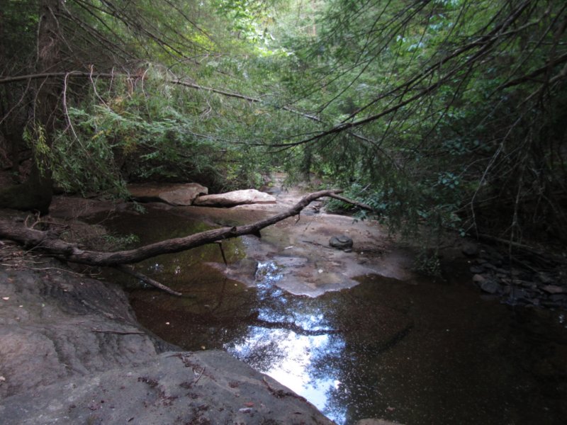
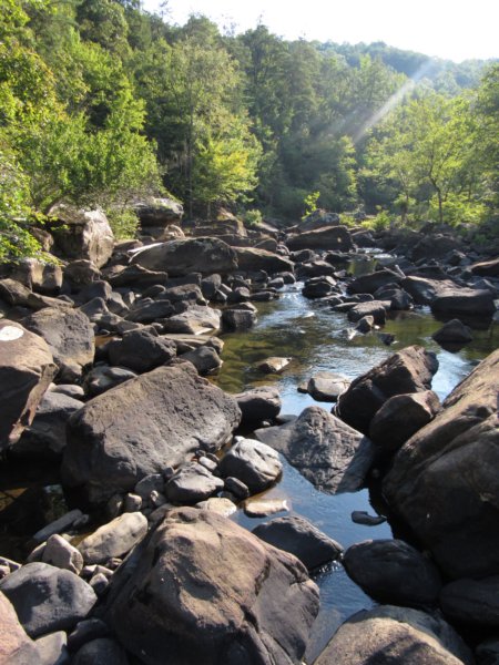
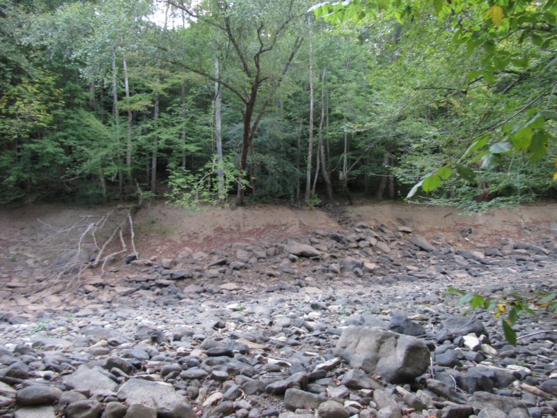 Back on the main trail, the boulders continued, though the trail was washed out in spots, completely exposing an old metal culvert. I found green dragon, post bloom, something I don't see often but enjoy finding. As the trail rounded a hard bend, it split again. To the left the Polly Branch campsite was barely a tenth of a mile, but I was eager to see and compare Bee Branch Falls, about half a mile down river to the Bee Branch Falls I'm familiar with back home. Lower Polly Branch Falls was just downhill from the junction, and at least had more water to it than the upper branch, but flow was still low. The falls seemed not much more than about 10-15', but something I'd love to venture back and see in full form one day. The old road bed, the Caney Fork River Trail, led the way uphill and down through a couple of dry drainages and tall knolls. I passed beech trees with carvings too old to decipher anymore and lots of pig sign as well, but no bear. I'm not sure why I was so concerned with bears this trip. High up on the hillside I spotted what looked like the rock that was the false Bee Branch Overlook, and then came across a wide drainage with a trickling double stream. There was no sign anywhere here that this was the way to Bee Branch Falls, though I tried to fight my way up through the underbrush to see some signs of trail or anything before giving up. I knew I was short on daylight and really wanted to have camp set up with time to spare. Frustrated and stubborn, I convinced myself I hadn't gone far enough, and kept pushing through young hemlock and gorgeous open expanses of mature woods. The dry Caney Fork came into view on my left, and I was immediately worried that I hadn't brought enough water with me. It hadn't occurred to me that I'd be camping next to a completely dry riverbed, nor did I know where the river normally flows and doesn't due to the karst nature of the area. The trail ventured steeply uphill, sitting on a high bank 20ft above the water now, and I would have turned back, had I not found a bit of a cryptic message of �B B 9-24-??� spray-painted in blue on a beech tree. There was no drain or stream here to speak of, so I ventured farther in hopes of finding something more. Instead, the trail let back downhill to a flooded wash area of Caney Fork before heading up another tough climb that seemed to be rounding a bend. I stopped, studied the map, frustrated at myself now because I knew I'd gone too far, and turned around heading back toward camp. I found an softball sized hornets nest no longer in use on the ground, and that offered some consolation for the wasted time. Also through here I found what I believe was a summer or autumn coralroot, but I'm definitely not certain. Arriving at the campsite to find not a single person, I took a spur trail down to some more fire rings to also find no one around. Baffled at the lack of campers, but happy with the array of camping choices, I chose a site right at the edge of the river to hang my hammock, where a cool breeze at least would help some with the heat. The spot already had a nice fire ring built, but wood was scarce. I explored the dry river bed downstream a ways, and from the center, I'd probably have been 10-15ft under water during a flash flood or high flow. The river seemed to travel uphill, but it was really probably nothing more than the large long deep pool becoming quickly shallow a long series of rapids. The drought had reduced even these rapids areas into nothing more than a few shallow pools of stagnant water. It took crossing the river completely to find loose wood to burn. I found more of the tiny light blue lobelia and the taller lovely cardinal flower enough a bit of a damp area, and also took note of a lot of woodpecker activity in a far tree, but never heard any milling about. As I crossed back, wood phlox and fruits from bigleaf magnolias dotted the ground, and I found even more firewood to use. Adjacent to my campsite was the obvious work of beavers, having completely chewed through a tree that ended up splintering and wedging into another tree instead of falling. Remarkably, with just that tiny sliver of bark, the tree lives on.
 Once rested and settled at the site, I debated greatly about abandoning the camping tripdue to my worry about bears and being alone out there. I ended up discovering I had enough paracord in my pack to string the food bag up in a tall tree, and used some of the large branches as a barrier. The concept of a barrier was a complete joke, I'll admit, and I'm not sure why I felt as insecure as I did in this spot. I made an early and nice fire, and once the initial stack of wood burned out, I called it a night, reading some in Cheryl Strayed's �Wild� book, which seemed a bit fitting. Morning brought no sign of anything disturbed, and I made quick work naturalizing the site, though I left the existing fire ring. I studied the map, and decided I had enough water to make the long loop up to Clifty Creek and above the ridge to hike out. Heading north on the Caney Fork Trail from camp, there were large clusters of rattlesnake plantain and indian cucumber root, the first I'd see on this trip. I crossed a small dry stream, way too narrow to be the Copper Cascades. Ahead, the well identifiable path degraded into nothing as the rocky hillside formed a long flat floodplain like area, and I searched for a while before giving up and continuing on north bushwhacking until I found the path again. Even here it resembled a four wheeler trail more than a hiking trail, but the natural beauty of the area made it something that could be overlooked. At least the trail here was not being sprayed with herbicide. Heading uphill the views of the river below would be pretty nice in a winter setting, and the large boulders along the way would pop even more. Down and up another little hill and the first glimpses of water that didn't look entirely stagnant came into view, though this river still wasn't flowing much, if at all. The trail nearly disappeared at times through again, but the wildflowers didn't as doll's eyes and large patches of iris filled in some of the wetter spots. Another long narrow hill flanked by hemlock, and the path descended into a boulder field that was most obviously Copper Cascades. I can only imagine the name is because of the rock's colors when wet, or perhaps higher levels of tannins from the hemlocks make the waters orange when the creek is actually flowing. There were some small puddles of water in the creek here, enough to support more cardinal flowers, but that's about it. The next section of trail was ruled by hemlocks and ferns and mosses all across the forest floor, the trail so faint at times I'd actually glad there were trees flagged to show the way. As the woods became deciduous again, a number of small streams and springs seemed to crop up from the hillside. What few I check, though, also didn't appear to be flowing. Up and over more hills, my now tired knees didn't have much fun climbing over and through a pretty heavy deadfall, before venturing over even more deadfall where the trail was completely lost in a jungle of knee high grass and jumbled head high trees. I climbed them more or less for a view downhill, and spotted an old road that seemed the best likelihood as a continuation of the trail and set out down that. The trail continued a bit much the same before the turn off sign for Clifty Creek became visible. Half old road, half rocky intermittent stream, the spur led quickly down and dead-ended at Clifty Creek, which was flowing. The sudden roar of water meant finally the Caney Fork was flowing! I made my way down rock hopping the large boulders, taking a break on one in the middle of the river with an absolutely fantastic view upstream. This was the view I'd seen in many of the photos I'd found online and had hoped to camp at, but there would have been nowhere here to camp. Lots of joe pye weed and cardinal flower to photograph, along with tall bellflower. Back off the spur, the trail uphill turned into another scramble over and under blow downs on a narrow little water channel, which ended up crossing a well maintained trail that led both directions. This doesn't line up on the map, and I have no idea where this was supposed to tie in from the Clifty Creek spur unless there existed a trail somewhere on the far side that I did see. At any rate, I continued the direction I knew the trail should go, with the bluff above me occasionally offering some nice little overhangs, but nothing really worth exploring. Around and up a hard bend, I passed fall aster as the trail became a mostly reclaimed road bed again. I picked mountain mint along the way, as I love the smell, and stuffed some leaves into the side pocket of my camera bag. Continuing decisively uphill, the canopy broke open as I came into a field of some sort, which appeared clear cut versus an actual farming operation. Almost hidden in the shrubbery at one side were signs directing which way to go of the three routes before me, along with the first trail markers I'd seen in a while. I veered left onto the Chestnut Mountain Ranch Trail, and with my cell phone almost dead, I decided to test out the rechargable pack I was gifted the previous Christmas and kept forgetting to bring on trips; it worked remarkably! With flat ground again, and a wide girth of land bushhogged for easy hiking, I only stopped along this stretch to photograph horse nettle, rabbit tobacco, heal-all, and lobelia in bloom. I found old coyote scat along the way, and tried to peek through the trees for glimpse out over the canyon. The open field brought the first butterflies to the adventure, with a pipevine swallowtail patient enough to allow me a few shots before fluttering on. As I continued uphill, the trees thickened in parts again, mostly along stream beds before returning to the prairie meadow type landscape. Small rock outcroppings along the thickly forested bluff edge gave a few peeks of Caney Gulf. I ventured through another bend and I spotted a little american toad in the next wet area, and the wildflowers really became abundant, with whorled coreopsis and lanceleaf gumweed, a rare plant, queen anne's lace and brown eyed susans. The answers to the questions I'd had about the large area being logged were revealed as well near here, as a sign notating the area as a demonstration project, another portion of the habitat restoration project with TWRA and SAHC I mentioned earlier in the hike. They purposely burned different areas to different extents and they're using the area to compare growth rates and bird population returns. When the trail finally ventured back into the woods, I took the spur to the Screw Cliff Overlook, a nice little viewpoint with a small campsite as well. Due to the forest continuing to grow, this overlook will be soon be obscured. I ambled along through the tall forest, glad to be out of the midday heat, almost stepping on a four foot black racer that locked me into a stare down contest. It was remarkable the speed at which he moved as he passed. My tired knees were no match for him this day. The forest here was a tale of two stories. The mature pine to the left were in great juxtaposition with the <10ft deciduous trees in the burned area to my right. Soon the burned area became a memory as mature mixed deciduous-pine forests took over, and I crossed what was likely the upper reaches of Jenny Branch, which had water. After stopping to snap photos of a great spangled fritillary butterfly, I continued on through the same bushhogged path, thick with grass at times until the upper reaches of Polly Branch became visible, surrounded by lush ferns.
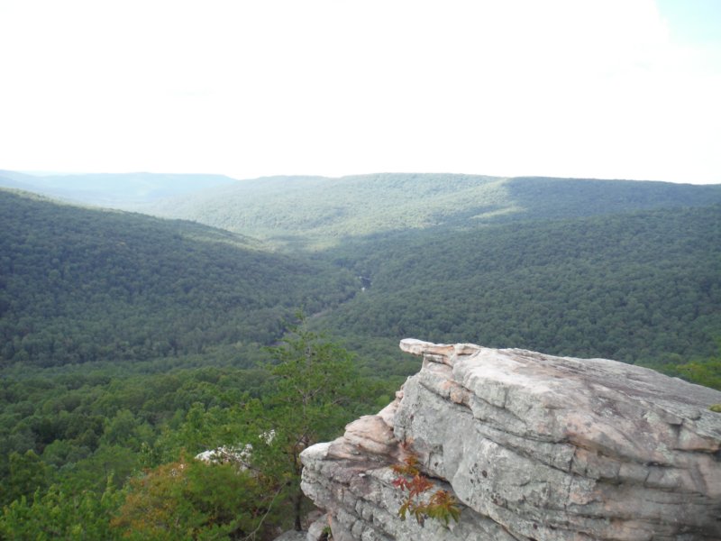
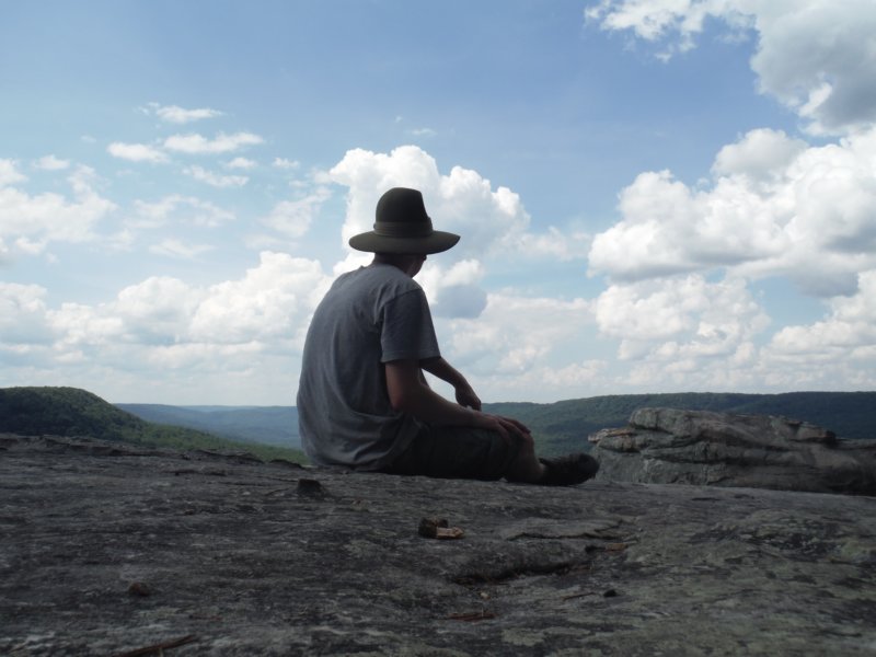 A lot of confusion ensued at the next trail junction, with obvious paths left and right here. I followed right uphill, until what looked like the back of someone's farm [I'd later learn this was park headquarters, and closed that day]. Back left, and crossing the creek, the path led uphill for a long ways with no markers, the only thing to belay fears about this being the correct path were the footprints of other people I could see in the sandy dirt. I hiked this section fast and hard, not really stopping to look or photograph anything other than a sign that said main trail, which I ventured a look at, confusing me even more. Back on the trail I was on, I kept on until it hit the gravel road I'd driven in on. I can only surmise the other spur I'd seen beforehand led back and joined at the main kiosk. I turned down a ride from some folks, as it was only about 10 minute walk back to the car from here. Covered in gravel dust from people passing, I climbed into the car and decided to round out the hike on a high note, and see if I could find the Welch Point Day Use Area. Passing the parking area for Virgin Falls, it's the first right turn where the road splits at a helicopter landing site. I followed that windy road for a while, before parking next to an old water pump that didn't work for me that day. The road down to the point was short, and hot, but the view from the point out over Scott's Gulf here was second to none. At some point downstream from where I camped, the river most certainly picked up again, and though I looked, I couldn't really tell from where exactly where the Virgin Falls Trail led out to a sandbar on the river itself. A well earned view and reward for the long last leg of the hike, and a perfect cap off to the weekend trip before heading home.
|