|
 Stone Door/Greeter Falls Loop:
June 3, 2013
Savage Gulf State Natural Area, TN
Distance: 13 miles
[View Photo Gallery]
It’s a rare treat to be off on a Monday, and even rarer of late to go on a long day hike. With no plans I set out for a place in the South Cumberland State Park in Tennessee that I’d never hiked before, the Savage Gulf State Natural Area. It encompasses a fairly large area, and I’d decided a on what looked to be a good, ambitious day hike. I arrived at the ranger’s station shortly after 9am, and chatted briefly with a worker. There were several wildflowers in bloom here, most notably trillium that hadn’t died off yet. I signed in, picked up a map, and took the trail down to the overlook for Laurel Falls.
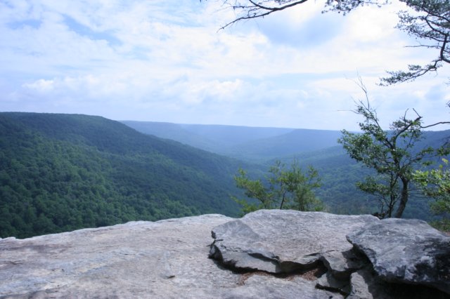
It was a steep enough descent, with railroad ties acting as buffers to keep the trail from eroding too bad. It would be terribly slick after a heavy rain. As I got closer to the falls the hemlocks started popping up in places, a change I’ve always welcomed, especially in my beloved Sipsey Wilderness. Also here and in bloom, were mountain laurels, scattered in little groups here and there. The terrain became really steep here, but a staircase/boardwalk was installed to alleviate part of that problem. Large flat rocks at the bottom of the staircase followed the bend in the terrain to a platform overlooking Laurel Falls and its canyon blow. The rains from the day before certainly helped the flow a bit, which probably would have been a good bit lower otherwise. I found two flowered cynthia in bloom as the trail wandered on down to the flat rocky area above the falls. It was dry enough to walk almost up to the edge here, and showcased an even better view of the canyon where more mountain laurel grew from the cracks in the rock. I made my way back up the steep, but uneventful last bit of trail to finish the loop back to the ranger station and check-in kiosk. There was a sign on the kiosk that made mention of rattlesnakes, something I’d also read about on the state park’s website, an extra incentive to keep myself on the established trails. Grabbing a couple of maps [I always take a backup], I set out down the paved trail to the stone door. This was exceptionally easy walking, which I welcomed, knowing the steep, rocky walk down to the valley would be a huge time drain. I found summer bluets in blooms, the first time I’ve seen this variety in bloom. After crossing a seasonal drain, the trail split, a trail to campsites to the right, with the trail continuing on to the left. I kept on the paved path, slowly but steadily going uphill to the Laurel Gulf Overlook. This was a great view, and you could see the other canyons or gulfs to the east that contained many more miles of trail than I’d get to see on this outing. The paved part of the trail ended here. Just past the overlook, the blueberries were setting fruit, but still too early to pick, what a treat that would have been! I found spotted wintergreen in spots shortly before a nice bridge over a narrow but flowing stream. Heeding the rattlesnake warning, I didn’t venture off trail to see where it led, though I presume a nice waterfall was not far to my left here. The steep cliffs would have made it very hard for a safe photo, though. The trail veered left and uphill and there was a neat dead tree of some kind, that appeared to be of some significance because of it’s shape, but there was nothing on the trail map/brochure about it and no sign here on the trail, so I wandered on. The trail wandered back and forth between some almost-views and then back into the forest and over shallow bridges, passing several big colonies of trailing arbutus. Soon I arrived at the big trail junction, where the stone door trail ends and splits into the Big Gulf Creek and Big Gulf Rim trails. There were two overlooks here, but I believe they are collectively called the Stone Door Overlook, and by far, the most impressive I saw that day. The first overlook passed by a fenced off sink, and then kind of stair stepped down a little to a large flat outcropping. I chatted with a guy here who was carrying around snake tongs, and mentioned he’d seen the sign at the sign in kiosk about rattlesnakes being spotted where we were and he was hoping to find one. I wished him luck on his adventure and continued on mine, taking in a very wonderful view to the east here, looking down the heart of the big canyon. A slip here meant a drop of about 150ft to the valley floor. I briefly wandered around the other overlook, which sported a nice bridge at the start of it, but it was largely obscured by trees and the other higher overlook.
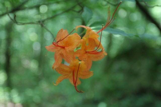
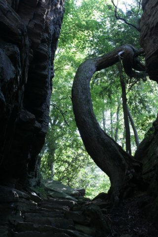
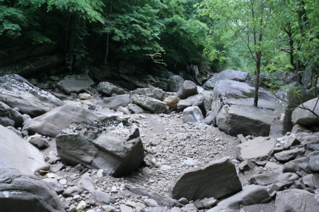 As I started down through the great stone door I stopped to look at the really interesting, contorted pine tree that managed to somehow survive here and reach up and out of the crevice to find sunlight. The steps here were pretty steep, but thankfully not slick. I’d read that the native americans carved this pathway centuries ago. It’s really the only access down into the canyon here. I briefly met the snake guy again who was still searching to no avail at finding a rattlesnake here; I’m rather glad I hadn’t seen any so far. The start of the Big Gulf Creek trail was here, and began the rockiest and steepest part of the entire day’s hike. I decided this was the best way to ‘attack’ the trails, since it offered me a flat 3 mile hike out on the rim trail were I to lose daylight versus a very hard and rocky uphill grind to end the hike. The trail began a series of small switchbacks, and hugged a gigantic boulder embedded into the side of the hill, very flat and steep. A slide down this thing meant a forty foot skid to more rocks and hard earth. Poison ivy was out everywhere here, and various ferns and oxalis popped up here and there from between rocks and around trees. Descending the terrain here I came across squaw root, skullcaps and a few different color variations of tradescanthia. I also encountered a large cluster of basil bee balm, very fragrant and wonderful. I checked out a small, odd placed rock shelter with an abandoned, but clean, fire ring, and continued downhill through some very rocky spots. More wildflowers popped up along here, venus’s looking glass and indian pinks, among others. Not long after something very vibrant and very orange caught my eye: flame azaleas! I’ve wanted to see these in bloom for a very long time, and certainly didn’t expect to come across them here, though I’m unsure of their range. The fiery orange stands out very well in a sea of green this time of year! After passing some wood betony post bloom, which was a bummer, I finally came to a trail junction. A connector trail that leads over to Collins Gulf meets the Big Gulf Creek trail here. And while it seemed like I’d been hiking for quite a long time, there was still another 1.5 miles to go before reaching Ranger Falls. It was then that I began to realize how long this route I’d planned was really going to take. After a few more rocky areas, and stopping to look at some indian pink in bloom, I finally caught a glimpse of the creek, but it was dry. I’d missed some unmarked turn off down an old logging road here somewhere to see some springs that began to feed the creek again, but I did find some pockets of water at least, possibly from springs across the creek. This dry section is due more to the geology of the area, riddled with sinks and what not. The boulders in the creek were fun to hop around on, but I soon made my way back up the steep bank and continued on, going through a little hemlock grove where I found rattlesnake plantain (not yet bloomed) and indian cucumber still in bloom. The long flat section of trail here was a welcome reprieve from the rocky downhill section. Turning downhill at the junction with the Ranger Falls trail, the trail quickly became a lot harder to find. After searching a bit across the wide rocky creek bed (still dry, but with a high water mark about 8ft up), I found the trail again on the right side of Ranger Creek (also dry). The trail had some really big mountain laurel, close to 20ft tall in spots, probably the largest I’ve ever seen. Obviously underused, this trail was much more intimate, much more narrow, which was nice. It crossed the creek once (still dry), and straddled the very high bank for a while. I stopped for a moment to photograph a millipede, and some just past bloom bent trillium, but the sound of rushing water ushered me onward. The trail turned and went straight up the creek bed, which went uphill before descending into a bowl shaped area. Ranger Falls was a wonderfully wide 30-35ft tall waterfall that fell into a very shallow plunge pool, before running sideway and backwards into the rock shelter itself (a sink!). I sat here for a while and enjoyed a lunch and a great waterfall all to myself.
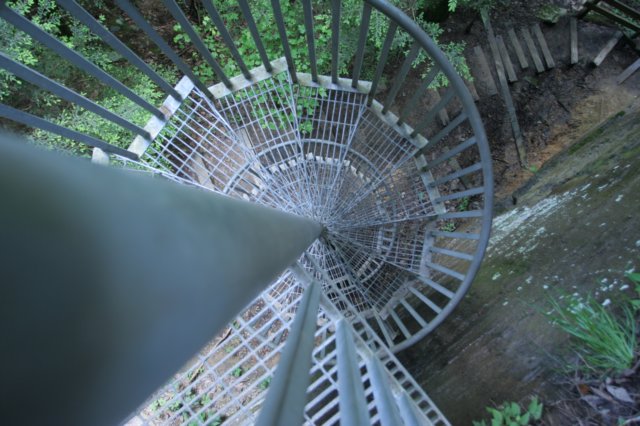
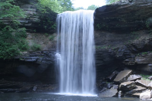
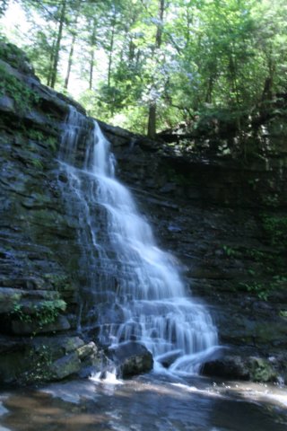 I made my way back to the trail junction, and pushed uphill, passing more flame azalea and some sweet shrubs. Off to the left of the trail, but not really accessible was an area of rocks on a little bit of a knoll that appeared to be arranged, at least to me. The area was very grown up and looked like it hadn’t been disturbed in some time, but I was very curious as to what this was, if anything. The trail kept a slow but steady climb past boulders that seemed to be the size of small countries in spots, and I nearly walked into an animal’s den of some kind on the back side of one that looked more like a cave or split in the rock at first glance. Just as the creek began to get out of view, the trail took a nose dive and the sound of rushing water caught my ear again. Here is where Big Gulf Creek gets gulped. In less than 200ft the creek goes from raging rapids to absolutely nothing. The bluff on the far side was really nice, about 60-75ft high, with a small waterfall bouncing down it before it disappeared into a sink as well. The force of the was so strong that in spinning and pooling here at the sink it completely cleared an area on the bottom of rocks to nothing but sand. As wonderful as it would have been to have dived in here and enjoyed the cold water on a hot day, there were probably too many mysteries at play with the currents to make it safe. After chatting with some guys who’d passed me a while back and were enjoying their lunch here, I continued on, once again, uphill. I passed squaw root and more bee balm and crossed a series of small wet weather streams. I did spot one waterfall way up hill on one of them, but it was too far and too risky to climb up for a better view. Soon I came to the only tricky spot on the trail. It’s splits, with no signs or obvious markings which way was correct, though I should have checked my map. I took what looked like the easier route, which just led down to the water and then disappeared. The true route was a bit of a slick, steep scramble over some tree roots, and an even steeper walk uphill on some steps put in to stave off erosion (and help with the climb I suppose). Just as it thought about leveling out, it took the steepest climb yet, and I began to doubt whether I should have saved this as the exit point on the hike. The sound of water was close again, and through the brush I could see a nice waterfall, though no way down the steep bank to get to it, except for a small section of the upper cascades. I continued on up to the junction with the Greeter Falls trail, and discovered I’d made a big error in mileage calculation. I’d treated Greeter Falls as a loop trail, and while one exists, it doesn’t from this route in, meaning an additional 1.4 miles I’d have to do. It was late in the day, and I knew I’d have to make haste if I wanted to see this waterfall and make it back to my jeep before dark. I crossed the small rock dam that’d been built over this unnamed creek, and followed the trail uphill again. I stopped at a nice overlook, where you could hear the creek and Greeter Falls roaring in the distance, though one could only spot a small section of the creek here through the foliage. A small toad of some kind crossed my path, and I took a few photos of him, the only photos of wildlife I managed to get that day (the chipmunks and squirrels were too fast). The trail hooked a sharp right, where Boardtree Falls could be heard, and I crossed a neat suspension bridge after giving up at finding a way down to see it. As luck would have it, over time a social trail on the far side of the bridge led down to the base of the upper part of the falls, a really beautiful cascading type waterfall. I do wish I could have seen the lower half of it, but with no time to bumble around through the underbrush, I just kept onward. The bluffs along this section of trail were really high, probably close to 100ft or so, and there were some small ups and downs as the route hugged close to the rock for a while. Making it to the junction, I debated on which section to see first, and decided with the lower falls route. I was very quickly rewarded with one of the quirkiest things I’ve ever seen on a trail: a spiral staircase! This section was a bit dangerous, as one could just walk right off the edge of the cliff here if you wanted and take a good 20-30ft fall to the rocky ground below. The stairs were very tight and narrow, and the steps too small for my big feet. It was really only here that one became to see just how grand this area was. After a few photos from a small lookout area, it was another 30 steps down to the base of the falls itself, a very large plunge pool in front of a 50-60ft waterfall. There was no real safe way of getting closer than 100 or 150ft of the falls without getting in the water here. It appeared to have a social trail that ran along the right side with a narrow crossing beneath the falls, but I didn’t attempt it due to time and some shaky knees by this point.
 I wandered on back to the trail junction and took the short path to the upper falls area, meeting the ‘snake man’ I’d met when I started the hike early that morning. He mentioned that I startled him, which I laughed at. He had no luck finding rattlesnakes, but did find a 6ft rat snake and a black racer. I asked if he’d taken the rim trail over, and he replied that he just drove to the other trailhead and came down. He was shocked that I was still hiking. He also mentioned that the best shot of the upper falls required you to stand in the middle of the creek and shoot. Soon my shoes and socks were off and I was finally enjoying some respite from the heat, and the cold water eased some soreness. By now time was running short, with the forest already beginning to cool off a bit. If I wanted to be out at a reasonable time, I’d have to take on the last 5.5 miles of this hike in pretty rapid fashion. I dislike rushing a hike, but I soon wouldn’t mind it. After a failed attempt to refill my water bottles above Boardtree falls (the water filter spit chunks of charcoal and murky water out for some reason), I quickly made my way back to the big creek gulf trail and started uphill yet again. This section was wide, possibly an old road bed of some kind, and the trail part turned east over more level ground. I passed the pit toilet (this is why I filter my water, you never know what you’ll find out there) and the Alum Gap campsite, and kept up the brisk pace. The Big Creek Rim trail was fairly uneventful, except for when it decided to make some ‘dead man’s curves’ at various overlooks along the way, some of which made me uneasy, and glad the rock was dry. I did stop for a bit at one and enjoyed watching a group of hawks flying long circles up and down the canyon. It’s a very peaceful experience to view for me. The trail eventually pulled deeper into the woods, crossing some wetter, slightly flowing streams and once again, some wildflowers, such as two flowered cynthia and woodland phlox (first I’d seen of this all day). After another couple of miles, and one more flame azalea, I made it back to the stone door area on good time! I took it leisurely the rest of the way back, stopping again at the Laurel Gulf Overlook, before dutifully signing out at the kiosk and making my way home.
|