|
 Hurricane Creek:
January 1, 2012
Bankhead National Forest, AL
Distance: 4.75 miles
[View Photo Gallery]
I made a rare new years resolution to make every adventure epic. Hurricane Creek had no problem making sure that resolution held true. Along the way I discovered several waterfalls, a rich area for spring wildflowers and the unwrapped a little more of the mystery, beauty and intrigue of the Bankhead National Forest.
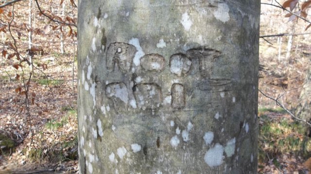
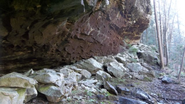
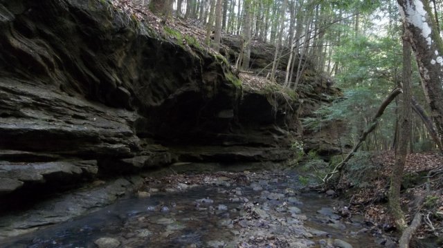 Finding the correct road to even get there, though, can be frustrating, as it’s labeled differently on different maps, but it’s FS 238 you’re looking for. It’s also the last road before reaching the shooting range in Bankhead. Once you find it, you can park anywhere, and as long as you drop off on the southern side of it, you’ll be in the correct drainage. I drove for about a mile down the road, passing a small culvert before parking and setting out. Like most all upper watersheds, the creek here was nothing more than a narrow meandering stream with feeders joining in every so often. Shortly after entering the forest I found a tree carved “ROOT 1901-“. I soon found another carved tree, with one date of “1930”, another carving on the same tree of “Nov 27”, and some native american symbols. The next half mile or so the stream progressively widened, and most of the trees here were hemlocks, which kept me thinking that the big waterfall wasn’t much further. Instead, I was greeted with more and more hemlocks, and eventually more rock features with every bend in the stream. Even though there had been recent rains, the creek here was easy to cross by rock hopping. I found a short 6ft waterfall, the put-in spot most people use when venturing here I’ve gathered. The rock walls along the creek began to rise some 30-40ft on either side here as well. I found a tree with seven arced slashes on it, which made me wonder if this was a reference to the seven Cherokee clans. I decided to walk along the bluff for a while, and found a group of filmy ferns and a small shelter across the creek that seemed to be occupied by something for the winter.
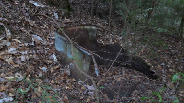
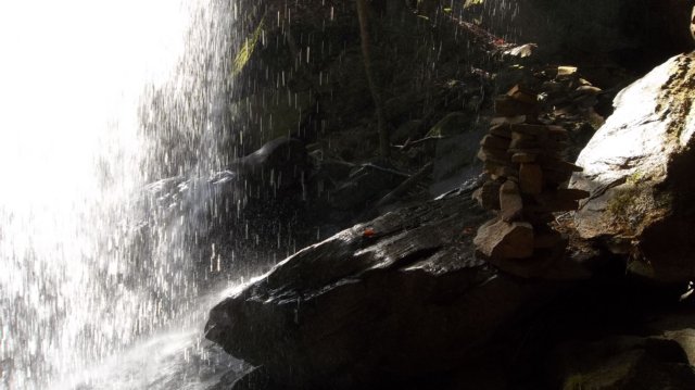
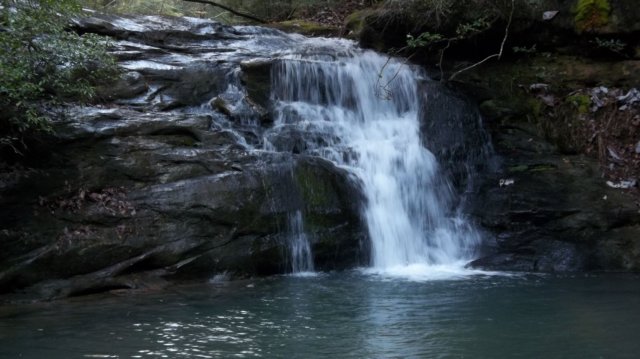 A long cascading waterfall then welcomed me, followed by another across the creek. The terrain began to rise a bit more here as well, and I eventually had to find a way of crossing the creek again. Here I found where the stream had undercut the rock bluff far enough it formed a shelter over the land on other side, resulting in a sandy beach area where nothing grew. You could almost hear the roar of the upper falls from here, and making my way downstream I came upon a marker tree and a large rusted out moonshine still. The creek bed here was solid rock and sloped, so that a narrow channel of water only a few feet wide rushed through. Standing on the edge of the upper falls and looking downstream though was a magnificent view. The huge plunge pool turned again into a narrow stream that slipped around a narrow sliver of land encased on both sides by rock walls. One side of the falls was easily 70ft high, with a seasonal, wispy waterfall falling off of it a little downstream. The other side was only about 10-20ft high in places, but I managed to find an eroded section where I could get down by climbing tree roots for about five feet. Walking back upstream, I stopped here for lunch, but kept getting the feeling I was being watched or was in the presence of someone or something else, so I left quickly after. The upper falls area would be a wonderful swimming hole on a hot summer day, though I’m sure as isolated as this area is it is probably home to many snakes.
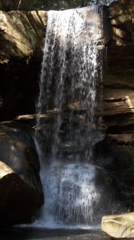 Within a short distance of the upper falls were two more mostly insignificant cascades, though I’d like to note something I found odd about the lay of the land here. Before both cascades and then afterward, the creek bottom was very thick with silt, and the creek itself wide. Probably 100ft before the cascades in each case, the land abruptly rose up, with a very clean break, became solid rock, and the creek was only about 2-3ft wide at best. You could hear the lower falls falling in a torrent from here now, and I crossed once to avoid having to climb steeply uphill. This resulted in me having to use the roots of a tree to climb up and over a rock to get down even on the other side, only to discover I had to cross back anyway. I found a dilapidated hunting stand built way up in a beech tree here, with long large nails driven in for use as steps. Squirrels were using it now for their base of operations. After studying the map a bit, I decided the easiest way down was to follow the ridgeline around to the south and find a way down. After some hustle and bustle through mountain laurels and across a feeder stream, I spotted what I thought was a much easier route down on the opposite ridge. Backtracking, I crossed the creek and followed a game trail nearly right on the edge of the bluff itself at times, a bit unnerving. I made my way down to the area I thought would be an easy get down, but it turned out to be a 10-15ft drop with a ledge kind of splitting it in half. I decided, as a precaution, to tie a rope around a tree above and dangle it down just in case I slipped, I could grab something to right myself. This turned out to be a very bad idea, as I did slip, and grabbing the rope with wet hands caused me nasty rope burn on several fingers, and I still ended up falling. After surveying myself for any serious injuries, and deciding there was no way to get back up the way I came to retrieve the rope, I went on to the lower falls and rested for a while and ate a snack. A very large bird of some kind, perhaps hawk flew down the canyon overhead, and I took my time snapping photos of the beautiful lower falls that reminded me much of a waterfall near my hometown. I also took noted of evidence of wildflowers, both hepatica and the cranefly orchid had their winter leaves out. If one were willing to brave the trek here it could be a interesting area to explore come spring.
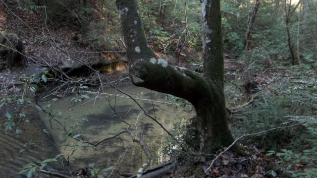
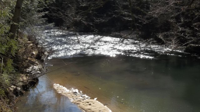
Satisfied and partially rested, I continued on downstream the short distance to the Sipsey River, exploring the bluff areas along the way. The river here was wide, deep, and rocky, quite different from what I knew of it further upstream near the picnic grounds. I’ve seen the river farther south, but only during late summer and a drought, which brought it down to knee deep at best in most places. One day I would love to canoe this section. I found an area here where the ridge I’d fallen from meandered down easy, with old road bed at that, and followed it back, retrieved my rope, and made my way up to the ridgeline. After briefly losing and recovering a cherished knife, I hacked through briar and scrubby areas until I found the active forest service road, and made a quick walk back to the car as daylight was fading.
|